








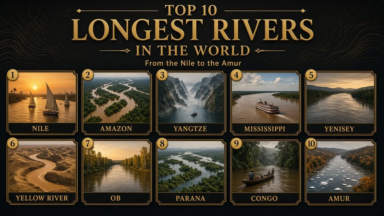
The longest rivers in the world are the Nile, Amazon and Yangtze, each over 6,000 km long, but the exact order depends on where a river starts and ends. This ranking lists the ten longest river systems on Earth with their lengths, courses, basins and the countries they cross.
Measuring a river sounds easy: follow the water from its source to the sea. In practice, every step involves a choice. Which of many headwater streams counts as the true source? Does the river end at the coast, or at the far edge of a wide estuary? Should the length follow the deepest channel or the centre of the stream, and on which year's map, since meandering rivers change course? Different answers to these questions explain why published lengths can differ by hundreds of kilometres.
To keep the list consistent, every length here comes from one source: Encyclopaedia Britannica's table of the world's longest rivers, which states that its figures are based on official sources and notes that measurement standards vary. Where other respected sources give different figures, the differences are explained. Basin areas, courses and discharge figures come from Britannica's individual river entries; discharge is given only where it could be confirmed.
Several of these lengths describe a river system rather than a single named river. The Mississippi, for example, is ranked together with the Missouri and its headwaters, because water from the far end of the Missouri flows all the way to the Gulf of Mexico.
The 10 Longest Rivers at a Glance
| Rank | River system | Length (km) | Length (mi) | Continent | Outflow |
|---|---|---|---|---|---|
| 1 | Nile | 6,650 | 4,132 | Africa | Mediterranean Sea |
| 2 | Amazon–Ucayali–Apurímac | 6,400 | 4,000 | South America | Atlantic Ocean |
| 3 | Yangtze (Chang Jiang) | 6,300 | 3,915 | Asia | East China Sea |
| 4 | Mississippi–Missouri–Red Rock | 5,971 | 3,710 | North America | Gulf of Mexico |
| 5 | Yenisey–Baikal–Selenga | 5,540 | 3,442 | Asia | Kara Sea (Arctic Ocean) |
| 6 | Huang He (Yellow River) | 5,464 | 3,395 | Asia | Bo Hai (Yellow Sea) |
| 7 | Ob–Irtysh | 5,410 | 3,362 | Asia | Gulf of Ob, Kara Sea |
| 8 | Paraná | 4,880 | 3,032 | South America | Río de la Plata (Atlantic) |
| 9 | Congo | 4,700 | 2,900 | Africa | Atlantic Ocean |
| 10 | Amur–Argun | 4,444 | 2,761 | Asia | Tatar Strait (Sea of Okhotsk) |
Source: Encyclopaedia Britannica, "World's longest rivers" table. Lengths are for the whole river system named.
Asia dominates the list with five of the ten, and three of those flow into the Arctic or Pacific through Russia. Africa and South America have two each, and North America one. Europe's longest river, the Volga, does not make the top ten, and neither does any river in Australia.
How Rivers Are Measured and Why Lengths Disagree
There is no single international standard for river length. Every published figure reflects decisions about four things.
- The source. Most large rivers are fed by many headstreams. By convention the source is usually the most distant point upstream from which water reaches the mouth, but the "most distant" stream can change as surveys improve.
- The mouth. Rivers that end in a wide estuary or delta have no single end point. Measuring to the open sea instead of the head of the estuary can add tens or even hundreds of kilometres.
- The route. A length measured along the winding channel is longer than one following a smoothed centre line, and the map scale used makes a big difference. Satellite imagery has made measurements more detailed, which often produces longer totals.
- Change over time. Rivers cut new channels, abandon old meanders and are shortened by dams, reservoirs and engineering works.
The Nile vs Amazon Debate
The most famous disagreement is over which river is the longest. Britannica and most reference works give the title to the Nile at 6,650 km, with the Amazon second at 6,400 km. Britannica also notes that the US Geological Survey considers the Nile to be about 100 miles (160 km) longer than the Amazon.
The case for the Amazon rests mainly on two points. First, researchers have proposed more distant headwaters in the Peruvian Andes. Second, the Amazon reaches the sea through several outlets, and one of them, the Pará, is really the estuary of the Tocantins River. If a measurement follows the Pará channel to the ocean, the Amazon gains a great deal of length. Critics reply that the Pará is not part of the Amazon itself. Until a measurement method is agreed internationally, both claims will continue to appear, and this list follows the long-standing consensus that places the Nile first.
Comparing Sources
| River | Britannica (km) | CIA World Factbook, 2025 edition (km) | Why they differ |
|---|---|---|---|
| Amazon | 6,400 | 6,436 | Choice of headwaters and mouth |
| Mississippi–Missouri | 5,971 | 6,275 | Factbook includes a longer headstream; reference sites often use the higher figure |
| Yenisey system | 5,540 | 5,539 | Effectively the same; the Factbook traces it through the Angara |
| Lena | 4,400 (ranked 11th) | 4,400 | The Factbook's top ten includes the Lena in place of the Paraná |
The CIA World Factbook was discontinued in February 2026, so its 2025 edition, preserved in online archives, is the last version. It is shown here only for comparison.
1. Nile
| Attribute | Details |
|---|---|
| Length | 6,650 km (4,132 mi) |
| Basin area | About 3,349,000 km² |
| Source | Headstreams of the Kagera River in Burundi, which feed Lake Victoria |
| Mouth | Mediterranean Sea, through a delta in northern Egypt |
| Basin countries | Tanzania, Burundi, Rwanda, DR Congo, Kenya, Uganda, South Sudan, Ethiopia, Eritrea, Sudan, Egypt |
| Discharge | Not given here; flow varies greatly by season and is regulated at Aswan |
The Course of the Nile
The Nile is formed by two great branches. The White Nile flows out of the East African lakes region, from Lake Victoria through Uganda and South Sudan. The Blue Nile rises at Lake Tana in the Ethiopian Highlands and carries the summer flood waters. The two meet at Khartoum, the capital of Sudan, and the combined river flows north across the Sahara to Egypt.
The River and Its People
For thousands of years the Nile's annual flood laid down the fertile silt that made ancient Egyptian civilisation possible. Today almost all Egyptians live in the narrow Nile valley and delta, which together form only a small fraction of the country's area. Finepedia's history of Egypt traces how the river shaped one of the world's oldest civilisations.
Lesser-Known Facts
- The Aswan High Dam, completed in 1970, ended the annual flood in Egypt and created Lake Nasser, one of the largest artificial lakes in the world.
- Through most of its course in Egypt and Sudan, the Nile flows through desert and receives almost no tributaries.
- The sharing of Nile water remains a sensitive issue, especially since Ethiopia built the Grand Ethiopian Renaissance Dam on the Blue Nile.
2. Amazon
| Attribute | Details |
|---|---|
| Length | 6,400 km (4,000 mi), measured with the Ucayali and Apurímac headwaters |
| Basin area | About 7,000,000 km², the largest of any river |
| Source | Headwaters of the Apurímac and Ucayali in the Andes of southern Peru |
| Mouth | Atlantic Ocean, in northern Brazil |
| Basin countries | Brazil, Peru, Colombia, Bolivia, Ecuador, Venezuela |
| Discharge | More than 175,000 m³ per second, the largest in the world |
The Course of the Amazon
The Amazon begins as mountain streams high in the Peruvian Andes, less than 200 km from the Pacific, yet it flows east across the whole continent to the Atlantic. About two-thirds of its main stream lies within Brazil. In its lower course it is so wide that, in places, one bank cannot be seen from the other.
The River and Its People
Britannica estimates that the Amazon carries about one-fifth of all the water that runs off Earth's surface into the oceans. Its basin holds the largest tropical rainforest on the planet and an enormous variety of fish, birds, plants and insects. Manaus, near the meeting of the Rio Negro and the Amazon, is the largest city in the rainforest.
Lesser-Known Facts
- The river was named in 1541 by the Spanish explorer Francisco de Orellana, who described battles with women warriors and compared them to the Amazons of Greek legend.
- No bridge crosses the main stream of the Amazon.
- At high tide, a tidal bore known locally as the pororoca can travel far up the river from the sea.
3. Yangtze (Chang Jiang)
| Attribute | Details |
|---|---|
| Length | 6,300 km (3,915 mi) |
| Basin area | About 1,808,500 km² |
| Source | Ulan Moron in the Tanggula Mountains of Qinghai province, on the Plateau of Tibet |
| Mouth | East China Sea, near Shanghai |
| Countries | China |
| Discharge | Not given here |
The Course of the Yangtze
The Yangtze is the longest river in Asia and the longest to flow entirely within one country. From the Tibetan Plateau it descends through deep gorges in Yunnan and Sichuan, passes Chongqing, cuts through the Three Gorges, and then crosses the lowlands of central and eastern China past Wuhan and Nanjing to the sea at Shanghai.
The River and Its People
The Yangtze basin is home to nearly one-third of China's population, according to Britannica, and produces a large share of its rice and industrial output. The river has been a major transport route for centuries; ocean-going ships can travel far inland.
Lesser-Known Facts
- The Three Gorges Dam, completed in 2006, is one of the largest hydroelectric projects in the world.
- In Chinese the river is usually called Chang Jiang, meaning "long river". The name Yangtze originally referred only to its lower section.
- The Yangtze river dolphin, or baiji, which lived only in this river, is now considered probably extinct.
4. Mississippi–Missouri–Red Rock
| Attribute | Details |
|---|---|
| Length | 5,971 km (3,710 mi) as a system; the Mississippi alone is 3,766 km (2,340 mi) |
| Basin area | About 3.1 million km² |
| Source | Headwaters of the Red Rock River in southwestern Montana (Missouri system); the Mississippi itself starts at Lake Itasca, Minnesota |
| Mouth | Gulf of Mexico, below New Orleans |
| Basin countries | United States (31 states) and Canada (2 provinces) |
| Discharge | About 17,000 m³ per second, the largest in North America |
The Course of the System
The Mississippi rises as a small stream at Lake Itasca in Minnesota and flows south through the heart of the United States. The Missouri, its longest tributary, joins it just north of St. Louis. When the Missouri and its headwaters in the Rocky Mountains are counted, the system becomes the longest in North America and the fourth longest in the world.
The River and Its People
The basin drains all or part of 31 US states and two Canadian provinces, an area that includes much of the country's farmland. Barges carry grain, coal and other bulk goods along the river, and its delta in Louisiana is one of the largest on Earth. Its average discharge ranks eighth in the world, according to Britannica.
Lesser-Known Facts
- Many lists give the system's length as 6,275 km. The difference from Britannica's 5,971 km comes from different headstreams and measurement methods.
- Levees, locks and channel straightening have shortened parts of the river and changed how it floods.
- For North America's other great rivers, see Finepedia's list of the longest rivers in North America.
5. Yenisey–Baikal–Selenga
| Attribute | Details |
|---|---|
| Length | 5,540 km (3,442 mi) as a system; the Yenisey itself is 3,487 km |
| Basin area | About 2,580,000 km² |
| Source | Headwaters of the Selenga River in western Mongolia |
| Mouth | Kara Sea, Arctic Ocean |
| Countries | Russia, Mongolia |
| Discharge | Not given here; sixth largest in the world, according to Britannica |
The Course of the System
This system links three waterways. The Selenga rises in Mongolia and flows into Lake Baikal in Siberia. The Angara drains Baikal and joins the Yenisey, which flows north across Siberia to the Arctic. The Yenisey roughly divides the West Siberian Plain from the higher Central Siberian Plateau.
The River and Its People
The Yenisey and Angara are among the most heavily dammed rivers in Russia, with large hydroelectric stations that power Siberian industry. Krasnoyarsk is the largest city on the main river.
Lesser-Known Facts
- Lake Baikal, through which the system passes, is the deepest lake in the world and holds about a fifth of Earth's unfrozen surface fresh water.
- The lower Yenisey is frozen for much of the year, and ice jams in spring can cause serious flooding.
6. Huang He (Yellow River)
| Attribute | Details |
|---|---|
| Length | 5,464 km (3,395 mi) |
| Basin area | About 750,000 km², the third largest in China |
| Source | Bayan Har Mountains in Qinghai province, at more than 4,600 m |
| Mouth | Bo Hai, an arm of the Yellow Sea |
| Countries | China |
| Discharge | Not given here |
The Course of the Huang He
The Huang He rises on the Plateau of Tibet and makes a huge loop to the north around the Ordos Desert before turning south and then east across the North China Plain. In its middle course it crosses the Loess Plateau, where soft, wind-blown soil is easily eroded.
The River and Its People
The river's name comes from the yellow loess sediment it carries in huge quantities. As that sediment settles, it raises the riverbed, so that in places the lower river flows above the surrounding plain between high dikes. When the dikes have failed, the floods have been catastrophic, earning the river the name "China's Sorrow".
Lesser-Known Facts
- The Huang He valley is regarded as a cradle of Chinese civilisation.
- The lower course has shifted many times over history, reaching the sea at points hundreds of kilometres apart.
7. Ob–Irtysh
| Attribute | Details |
|---|---|
| Length | 5,410 km (3,362 mi) as a system; the Ob itself is 3,650 km and the Irtysh 4,250 km |
| Basin area | About 2,975,000 km², the sixth largest drainage basin in the world |
| Source | The Black Irtysh in the Altai Mountains of China |
| Mouth | Gulf of Ob, Kara Sea |
| Countries | China, Kazakhstan, Russia |
| Discharge | About 12,700 m³ per second |
The Course of the System
The Irtysh rises in China, crosses Kazakhstan and enters Russia, where it joins the Ob in western Siberia. The Ob itself forms in the Altai region of Russia and flows north across the West Siberian Plain to the long Gulf of Ob on the Arctic coast.
The River and Its People
Novosibirsk, the largest city in Siberia, stands on the Ob, and Omsk on the Irtysh. The lower basin includes huge wetlands and some of Russia's most important oil and gas fields.
Lesser-Known Facts
- The Ob delivers roughly 400 km³ of fresh water to the Arctic Ocean each year.
- The Irtysh, at 4,250 km, is longer than the Ob into which it flows.
8. Paraná
| Attribute | Details |
|---|---|
| Length | 4,880 km (3,032 mi) |
| Basin area | About 2,800,000 km² |
| Source | Confluence of the Grande and Paranaíba rivers in south-central Brazil |
| Mouth | Río de la Plata estuary, Atlantic Ocean |
| Basin countries | Brazil, Paraguay, Argentina, Bolivia |
| Discharge | About 17,293 m³ per second |
The Course of the Paraná
The Paraná is South America's second longest river after the Amazon. It flows south and southwest from Brazil, forms part of the border between Brazil and Paraguay and then between Paraguay and Argentina, and crosses northeastern Argentina before joining the Uruguay River to form the Río de la Plata.
The River and Its People
The Paraná is a vital trade route for Argentina and Paraguay, carrying grain and soybeans to the sea. Rosario and Santa Fe stand on its banks, and its wide delta lies just north of Buenos Aires.
Lesser-Known Facts
- The Itaipú Dam on the Brazil–Paraguay border has an installed capacity of 14,000 megawatts and is one of the most productive hydroelectric plants on Earth.
- The famous Iguaçu (Iguazú) Falls are on a tributary of the Paraná, close to where Argentina, Brazil and Paraguay meet.
9. Congo
| Attribute | Details |
|---|---|
| Length | 4,700 km (2,900 mi) |
| Basin area | About 3,457,000 km² |
| Source | The Chambeshi River in northeastern Zambia, at about 1,760 m |
| Mouth | Atlantic Ocean at Banana, Democratic Republic of the Congo |
| Main countries | Democratic Republic of the Congo, Republic of the Congo, Central African Republic, Zambia, Angola, Cameroon, Tanzania |
| Discharge | About 41,000 m³ per second, second only to the Amazon |
The Course of the Congo
The Congo rises in the highlands of Zambia, curves north through the rainforest of central Africa and then turns west and southwest to the Atlantic. It crosses the equator twice. Below Malebo Pool, the lake-like widening between Kinshasa and Brazzaville, the river drops steeply through a long series of rapids and falls, including the Inga Falls.
The River and Its People
Africa's second longest river is a lifeline for transport in a region with few roads; boats link riverside towns over hundreds of kilometres. Kinshasa and Brazzaville, two capital cities, face each other across the river.
Lesser-Known Facts
- Britannica counts 32 cataracts on the lower river.
- The Congo basin is roughly half the size of the Amazon basin and holds the second largest tropical rainforest in the world.
- The Inga Falls area is often cited as having one of the greatest hydroelectric potentials of any site on Earth.
10. Amur–Argun
| Attribute | Details |
|---|---|
| Length | 4,444 km (2,761 mi) as a system; the Amur proper is 2,824 km |
| Basin area | About 1,855,000 km² |
| Source | Headwaters in Mongolia, northeastern China (Inner Mongolia) and Russia |
| Mouth | Tatar Strait, between the Russian mainland and Sakhalin |
| Countries | Russia, China, Mongolia |
| Discharge | Not given here |
The Course of the Amur
The Amur proper begins where the Shilka and Argun rivers meet. For much of its length, together with the Argun, it forms the border between Russia and China. It then turns northeast through the Russian Far East, past Khabarovsk, to the Pacific.
The River and Its People
In Chinese the river is called Heilong Jiang, meaning "Black Dragon River". Its basin includes forests that are among the last habitats of the Siberian (Amur) tiger.
Lesser-Known Facts
- The river freezes for several months each winter.
- Khabarovsk in Russia and Blagoveshchensk, which faces the Chinese city of Heihe across the water, are major river cities.
Just Outside the Top 10
Two great Asian rivers come close to the top ten, and one of them appears in it on some lists.
- Lena, Russia: 4,400 km (2,734 mi). It flows north through eastern Siberia to the Laptev Sea and is ranked 11th by Britannica. The CIA World Factbook's 2025 list placed it in the top ten instead of the Paraná.
- Mekong: 4,350 km (2,700 mi). Rising on the Tibetan Plateau, it flows through or along China, Myanmar, Laos, Thailand, Cambodia and Vietnam, and is ranked 12th by Britannica.
The difference between 10th and 12th place is less than 100 km, smaller than the margin of disagreement between sources for many rivers, so the bottom of any top ten list is always open to argument.
The Longest River on Each Continent
| Continent | Longest river | Approximate length |
|---|---|---|
| Africa | Nile | 6,650 km |
| South America | Amazon | 6,400 km |
| Asia | Yangtze | 6,300 km |
| North America | Mississippi–Missouri | 5,971 km |
| Europe | Volga | About 3,530 km |
| Australia | Murray (with the Darling as its longest tributary) | About 2,500 km |
Antarctica has no permanent rivers; its fresh water is locked in ice. The Volga, which flows entirely within Russia to the Caspian Sea, is far shorter than the Asian giants but still the longest river in Europe.
India's Great Rivers in Context
No Indian river makes the global top ten, but the rivers of the subcontinent are among the most important on Earth when measured by the water and sediment they carry and the number of people who depend on them.
| River | Length | Source | Notes |
|---|---|---|---|
| Ganga (Ganges) | 2,510 km (1,560 mi) | Gangotri glacier at Gaumukh, Uttarakhand | Drains about one-fourth of India |
| Brahmaputra | 2,900 km (1,800 mi) | Chemayungdung Glacier, Tibet | Known as the Yarlung Tsangpo in Tibet and the Jamuna in Bangladesh |
| Ganges–Brahmaputra system | Joins in Bangladesh | Both rivers above | Average discharge about 30,770 m³ per second, third largest in the world |
Source: Britannica entries on the Ganges River and the Brahmaputra River.
The Ganga
The Ganga forms in the Himalayas of Uttarakhand, where the Bhagirathi, rising at Gaumukh at the foot of the Gangotri glacier, joins the Alaknanda. It then flows southeast across the Gangetic Plain past Haridwar, Prayagraj, Varanasi and Patna into Bangladesh. Its basin is home to hundreds of millions of people and is one of the most densely populated regions in the world. The river is sacred to Hindus and was declared India's National River in 2008.
The Brahmaputra
The Brahmaputra rises in southwestern Tibet and flows east for a long distance as the Yarlung Tsangpo, at some of the highest elevations of any major river. It then cuts through the Himalayas in the Yarlung Tsangpo Grand Canyon, one of the deepest canyons on Earth, and enters India in Arunachal Pradesh, where it is called the Siang or Dihang. In Assam it becomes a broad, braided river and flows past Kaziranga National Park before entering Bangladesh as the Jamuna.
A World-Class River System
Measured by length, the Ganga and Brahmaputra are well outside the top ten. Measured by flow, together they rank third in the world, behind only the Amazon and the Congo. Britannica estimates the combined Ganges–Brahmaputra flow at about 30,770 m³ per second, with the Brahmaputra supplying about 19,800 m³ and the Ganges about 11,000 m³. Their combined sediment load, about 1.84 billion tons a year, is the highest of any river system in the world. All that sediment has built the largest delta on Earth, home to the Sundarbans mangrove forest shared by India and Bangladesh.
Longest Rivers vs Largest Rivers
Length is only one way to rank a river. Discharge, the volume of water passing a point each second, gives a very different order.
| River | Length rank | Approximate average discharge (m³/s) | Note |
|---|---|---|---|
| Amazon | 2 | More than 175,000 | Largest in the world by far |
| Congo | 9 | 41,000 | Second largest |
| Ganges–Brahmaputra | Not in top 10 | 30,770 | Third largest |
| Mississippi–Missouri | 4 | 17,000 | Largest in North America |
| Paraná | 8 | 17,293 | Second largest in South America |
| Ob–Irtysh | 7 | 12,700 | Major source of Arctic fresh water |
Sources: Britannica river entries. Discharge figures can vary by gauging station and period of record.
The Nile, despite being the longest river, carries far less water than any of these. Most of its course crosses desert, where evaporation is high and no tributaries join it, and its flow is heavily used for irrigation. The Amazon, by contrast, collects rain from a huge tropical basin and pours more water into the ocean than the next several largest rivers combined.
Frequently Asked Questions
Which is the longest river in the world?
The Nile, at 6,650 km (4,132 mi) according to Britannica. It flows north from the lakes region of East Africa to the Mediterranean, and its basin covers parts of eleven countries. Some researchers make the case for the Amazon instead, depending on how its source and mouth are defined.
Is the Amazon longer than the Nile?
On standard figures, no. Britannica lists the Amazon at 6,400 km, and the US Geological Survey puts the Nile about 160 km ahead. Claims that the Amazon is longer usually depend on a more distant Andean source or on measuring to the sea through the Pará estuary.
What is the longest river in Asia?
The Yangtze, at 6,300 km (3,915 mi). It is the third longest river in the world and the longest that flows entirely within one country. Its basin is home to nearly one-third of China's population.
Which is the longest river in India?
The Ganga is usually called India's longest river, at 2,510 km in total, most of it within India. The Brahmaputra is longer overall, at 2,900 km, but much of its length lies in Tibet and Bangladesh.
Which river carries the most water?
The Amazon, with an average discharge of more than 175,000 m³ per second. The Congo is second at about 41,000 m³ per second, and the combined Ganges–Brahmaputra system is third.
Why do sources give different lengths for the same river?
Because there is no international standard for measuring rivers. Sources choose different headwaters, end points and routes, use maps at different scales, and measure in different years as channels shift. The Mississippi–Missouri, for example, is given as both 5,971 km and 6,275 km.
Conclusion
The Nile, Amazon and Yangtze lead the world's longest rivers, followed by the Mississippi–Missouri, the Yenisey, the Huang He, the Ob–Irtysh, the Paraná, the Congo and the Amur. Five of the ten are in Asia, and three of those drain into the Arctic or Pacific through Siberia and the Russian Far East.
The lengths themselves are best read as careful estimates rather than exact measurements. Choices about sources, mouths and routes can shift a river's length by hundreds of kilometres, which is why the Nile and Amazon are still debated. Length also says little about a river's power: the Amazon and Congo carry far more water than the Nile, and India's Ganga and Brahmaputra together outrank every river in the top ten except those two by flow.
- Encyclopaedia Britannica, "World's longest rivers" (table of lengths), accessed October 2026. https://www.britannica.com/science/worlds-longest-rivers-2225894
- Encyclopaedia Britannica, river entries: Nile River, Amazon River, Yangtze River, Mississippi River, Yenisey River, Huang He, Ob River, Paraná River, Congo River, Amur River, accessed October 2026. https://www.britannica.com/place/Nile-River
- Encyclopaedia Britannica, "Ganges River" and "Brahmaputra River", accessed October 2026. https://www.britannica.com/place/Ganges-River
- Encyclopaedia Britannica, "Itaipú Dam", accessed October 2026.
- CIA World Factbook, 2025 edition (archived), Field: Major rivers (by length in km). https://worldfactbookarchive.org
- CIA, "Spotlighting The World Factbook as We Bid a Fond Farewell", 4 February 2026. https://www.cia.gov/stories/story/spotlighting-the-world-factbook-as-we-bid-a-fond-farewell















Log in with