









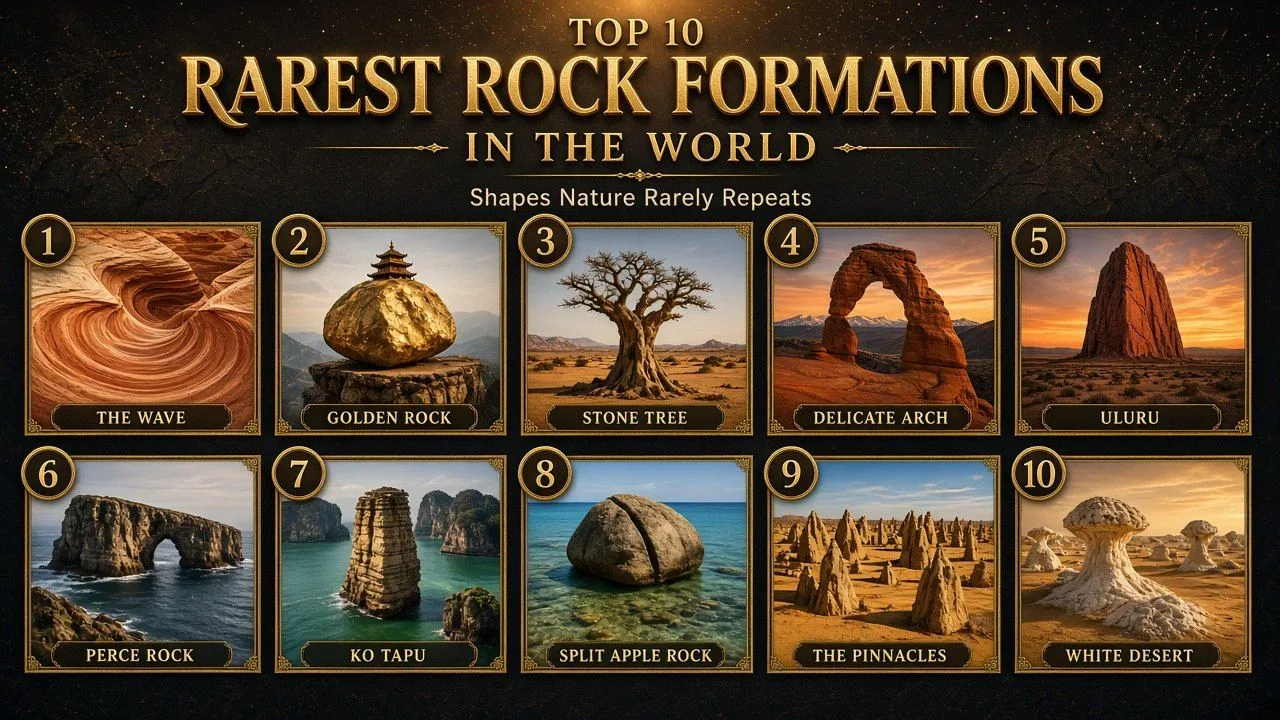
The rarest rock formations in the world include Arizona's Wave, Myanmar's Golden Rock and Bolivia's Stone Tree, shapes that wind and water almost never repeat.
Most rocks are ordinary. They sit in hillsides, riverbeds and road cuts, and nobody travels across the world to look at them. A handful, though, have been carved into shapes so unusual that they have become pilgrimage sites, national symbols and some of the most photographed places on Earth. Some balance where they should not, some stand alone in the sea, and some look like trees, mushrooms or a frozen ocean wave.
This guide covers ten of the rarest rock formations on the planet. For each one you will find a Quick Facts table, how it formed, what makes it unusual, why it matters and a few facts most visitors never hear. Measurements and dates come from national park services, UNESCO and geological descriptions, and figures that change over time are given with the year they apply to.
How We Chose the Rarest Rock Formations
Geologists do not keep an official ranking of rare rocks, and the word rare can mean different things. A rare mineral is one that exists in tiny amounts. A rare rock formation is a shape or structure that almost never forms, or that survives only because conditions in one place are just right. This list is about the second kind.
Each formation was judged on four questions:
- How unusual is the shape, and how many close look-alikes exist anywhere else?
- How fragile is it, and how likely is it to change or disappear within human time?
- How unusual is the process that made it, such as wind erosion of soft sandstone or a boulder resting on a tiny point of contact?
- Is it protected, restricted or otherwise hard to see, which is often a sign of how delicate it is?
The order is an editorial judgement based on those questions, not a scientific score. Formations that are both unique in shape and fragile rank higher than those that are better known but more robust.
Rarest Rock Formations in the World at a Glance
| No. | Formation | Country | Rock type | What makes it rare |
|---|---|---|---|---|
| 1 | The Wave | United States (Arizona) | Navajo Sandstone | Fragile striped troughs of fossil sand dunes |
| 2 | Golden Rock | Myanmar | Granite | A boulder balanced on a tiny point above a cliff |
| 3 | Árbol de Piedra (Stone Tree) | Bolivia | Sandstone | A wind-carved rock shaped like a tree |
| 4 | Delicate Arch | United States (Utah) | Entrada Sandstone | A tall freestanding arch on an open slickrock bowl |
| 5 | Uluru | Australia | Arkose sandstone | Near-vertical rock layers rising 348 m from a flat plain |
| 6 | Percé Rock | Canada (Quebec) | Limestone | A huge sea arch that has lost arches within recorded history |
| 7 | Ko Tapu | Thailand | Limestone | A 20 m spike that is narrower at the base than the top |
| 8 | Split Apple Rock | New Zealand | Granite | A round boulder split cleanly in two |
| 9 | The Pinnacles | Australia | Limestone | Thousands of pillars rising from yellow sand |
| 10 | White Desert mushroom rocks | Egypt | Chalk | Bright white pedestals carved by sandblasting wind |
1. The Wave
| Attribute | Details |
|---|---|
| Location | Coyote Buttes North, Paria Canyon-Vermilion Cliffs Wilderness, northern Arizona, United States |
| Rock type | Cross-bedded Navajo Sandstone of Jurassic age |
| Size | Two main troughs, about 19 m by 36 m and 2 m by 16 m |
| Managed by | US Bureau of Land Management (BLM) |
| Access | Day-use permit only, issued by advance and daily lotteries |
The Wave is a set of curving, striped sandstone troughs near the Arizona and Utah border. Its bands of red, orange, yellow and white swirl across the rock like a frozen sea, and it has become one of the most sought-after landscapes in American photography. It is also one of the hardest to visit, because only a small number of people are allowed in each day.
Origins and History
The stripes are the remains of giant sand dunes that crossed a desert during the Jurassic period, roughly 190 million years ago in this region. As the dunes moved, the wind laid down thin, alternating layers of sand. Over time the sand was buried, cemented and turned into rock, preserving those layers as fine stripes.
Much later, rare runoff water began to cut troughs along cracks in the sandstone. When the area that fed water to the troughs shrank, the wind took over. Today the troughs are shaped almost entirely by wind, which is funnelled through them and slowly sands away the softer layers.
What Makes It So Rare
- The stripes are real cross-bedding, a cutaway view of ancient dunes, exposed in an unusually clean and colourful form
- Layers cemented with slightly different grain sizes erode at different speeds, leaving thin ridges and ribs
- The ridges are so fragile that a careless footstep can snap them off
- There are no formal trails or signs to the site, which keeps the surrounding wilderness undeveloped
Why It Matters
The Wave shows how a fragile landscape can be protected without being closed completely. The BLM limits visits to Coyote Buttes North through a permit system, with one lottery held about four months ahead and a geofenced daily lottery for people already in the area. Demand is so high that most applicants never win a permit.
Scientifically, the area is also a window into Jurassic life. The wider Coyote Buttes area contains a dinosaur trackway with more than 1,000 footprints, and some deformed layers at The Wave are thought to record dinosaurs trampling wet sand before it hardened.
Interesting Facts
- After rain, temporary pools at The Wave can fill with hundreds of tiny tadpole shrimp
- A fainter formation just above it is known to hikers as the Second Wave
- The Wave became especially famous in Europe after it featured in the 1996 German documentary Fascinating Nature
- Photographers often prefer the hours around midday, when the troughs are free of shadow
2. Golden Rock
| Attribute | Details |
|---|---|
| Location | Mount Kyaiktiyo, Mon State, Myanmar |
| Rock type | Granite boulder covered in gold leaf |
| Size | About 7.6 m (25 ft) high, 15 m (50 ft) around |
| Elevation | About 1,100 m (3,609 ft) above sea level |
| Known for | Kyaiktiyo Pagoda, a 7.3 m shrine built on top of the boulder |
Golden Rock is a granite boulder that seems to hang on the edge of a cliff, as if it could roll into the valley at any moment. Worshippers have covered it in gold leaf for generations, so it glows from sunrise to sunset. A small pagoda sits on its top, and the whole site is one of the holiest places in Myanmar.
Origins and History
Geologically, Golden Rock is a granite boulder resting on a separate, sloping rock platform. The two pieces are independent. The boulder overhangs the platform by about half its length and touches it over an extremely small area, which is why it appears to defy gravity. Many other granite boulders on the same mountain sit in similarly precarious positions.
Buddhist legend gives a different explanation. It says the Buddha gave a strand of his hair to a hermit, who asked a king to enshrine it in a boulder shaped like his own head. The king found the rock at the bottom of the sea, and the strand of hair is said to keep it from falling. In the Mon language, the name Kyaik-htiyo is often explained as "pagoda upon a hermit's head".
What Makes It So Rare
- The contact point between the boulder and its base is tiny compared with the boulder's size
- Half of the boulder projects beyond the edge of its platform, over a sheer drop
- Few balancing rocks anywhere carry a shrine and receive daily religious offerings
- The gold leaf, renewed constantly by pilgrims, gives it a colour no natural rock has
Why It Matters
Golden Rock is the third most important Buddhist pilgrimage site in Myanmar, after the Shwedagon Pagoda and the Mahamuni Pagoda. The main pilgrimage season runs from November to March. Many devotees walk the roughly 11 km trail from the base camp at Kinpun, and legend says that making the pilgrimage three times in one year brings wealth and recognition.
Only men may cross the small bridge and press gold leaf onto the rock. Women are not allowed to touch the rock and pray nearby instead. On the full moon of the month of Tabaung, in March, the platform is lit with tens of thousands of candles.
Interesting Facts
- About 300 m away, a rock said to be the stone boat that carried the boulder is honoured as the Kyaukthanban Pagoda
- Pilgrims climb the last stretch barefoot, following Burmese custom
- A gold lotus pattern is painted around the base of the boulder
- Golden Rock is about 210 km from Yangon
3. Árbol de Piedra (Stone Tree)
| Attribute | Details |
|---|---|
| Location | Siloli Desert, Eduardo Avaroa Andean Fauna National Reserve, Potosí Department, Bolivia |
| Rock type | Soft sandstone |
| Height | About 7 m (23 ft) |
| Formation type | Ventifact, a rock shaped by wind-blown sand |
| Nearby | About 18 km north of Laguna Colorada |
Árbol de Piedra, Spanish for "stone tree", is a lone rock on the high Bolivian altiplano that looks like a stunted tree with a thin trunk and a wide, leafy crown. It rises from the sand dunes of the Siloli Desert in the far south-west of Bolivia, and it is one of the most photographed stops on tours between the Uyuni salt flat and the coloured lagoons of the Andes.
Origins and History
The Stone Tree is a ventifact, which means its shape was carved by wind carrying sand. On the altiplano, strong winds pick up grains of sand and drive them against anything in their path. This natural sandblasting is strongest close to the ground, because sand grains bounce low and rarely rise more than about a metre.
Over a very long time, the lower part of the rock was worn away much faster than its top. The result is a slender stem holding up a broad, heavier cap. The same process shapes mushroom rocks in deserts around the world, but few have such a tree-like outline.
What Makes It So Rare
- The stem is far narrower than the crown, a balance that only lasts while the rock remains intact
- It stands alone, so its silhouette is easy to read against the sky
- The soft sandstone records the direction and strength of the prevailing wind
- It sits inside a protected high-altitude reserve rather than a busy tourist zone
Why It Matters
The Stone Tree is a textbook example of wind erosion, one of the slowest and least visible forces that shape the land. Because it is so easy to understand at a glance, it is often used to explain how deserts change over time.
It also anchors tourism in one of the most remote parts of South America. The surrounding reserve protects flamingo lakes, volcanoes and desert, and the Stone Tree is one of its signature sights.
Interesting Facts
- Its name in Spanish, Árbol de Piedra, simply means "tree of stone"
- The reserve around it is named after Eduardo Avaroa, a Bolivian hero of the War of the Pacific
- Laguna Colorada, a red lake known for its flamingos, lies a short drive to the south
- Its thin stem of soft sandstone is the weakest point of the whole formation
4. Delicate Arch
| Attribute | Details |
|---|---|
| Location | Arches National Park, near Moab, Utah, United States |
| Rock type | Entrada Sandstone |
| Size | About 16 m (52 ft) tall; opening about 46 ft high and 32 ft wide |
| Named | 1933 to 1934, by expedition leader Frank Beckwith |
| Trail | 3 miles (4.8 km) round trip, climbing 480 ft (146 m) |
Delicate Arch is a freestanding sandstone arch perched on the rim of a natural rock bowl, with the La Sal Mountains often visible behind it. It is the most recognised landmark in Arches National Park and one of the best-known symbols of Utah, appearing on the state's licence plates.
Origins and History
The arch began as a fin, a narrow wall of Entrada Sandstone. Water, ice and wind gradually wore through the fin and widened the hole, leaving the arch that stands today. The same process created the park's other arches, but most of them are attached to cliffs or hidden among other rocks. Delicate Arch stands alone in open space, which gives it its striking outline.
Local cowboys once called it "the Chaps" and "the Schoolmarm's Bloomers". The current name was given by Frank Beckwith, who led a scientific expedition to the area in the winter of 1933 to 1934. Interestingly, the arch was not part of the original national monument created in 1929. It was added when the boundaries were enlarged in 1938, and the area became a national park in 1971.
What Makes It So Rare
- Arches National Park holds more than 2,000 natural sandstone arches, the highest density of arches in the world
- Even among them, a tall arch standing on its own, with no supporting cliff, is unusual
- Every arch is temporary, and the park has already lost famous ones to collapse
Why It Matters
Delicate Arch is a reminder that even the most iconic landforms are short-lived on a geological timescale. In the 1950s the National Park Service studied coating it with clear plastic to slow erosion, but dropped the idea as impractical and against its principles. Today the policy is to let natural processes run their course.
It is also one of the busiest hikes in the park. Arches received just under 1.5 million visitors in 2024, and many of them make the uphill walk to see the arch at sunset.
Interesting Facts
- The Olympic torch relay for the 2002 Salt Lake City Winter Games passed through the arch
- White-throated swifts nest at the top of the arch in summer
- After a climber free-soloed it in 2006, the park banned climbing on all named arches
- Delicate Arch appeared on a 2014 US quarter in the America the Beautiful series
5. Uluru
| Attribute | Details |
|---|---|
| Location | Uluṟu-Kata Tjuṯa National Park, Northern Territory, Australia |
| Rock type | Arkose, a coarse sandstone rich in feldspar |
| Size | 348 m (1,142 ft) high; 9.4 km (5.8 mi) around |
| Protection | UNESCO World Heritage Site since 1987 |
| Traditional owners | The Aṉangu people |
Uluru, also known as Ayers Rock, is a vast sandstone mass rising from the flat red plains of central Australia. It is famous for changing colour through the day, glowing deep red at dawn and sunset. It is also one of the most sacred places for the Aṉangu, the Aboriginal people who have lived in the area for tens of thousands of years.
Origins and History
Uluru is made of a rock called the Mutitjulu Arkose. It began as sand and gravel washed off a mountain range to the south about 550 to 530 million years ago, forming a huge alluvial fan. The sediment was buried and turned to rock, and a later episode of mountain building tilted the layers until they stood almost vertical. Uluru's strata dip at about 85 degrees, and erosion has since stripped away the softer rock around them.
In 1873 the surveyor William Gosse saw the rock and named it Ayers Rock after Sir Henry Ayers, then Chief Secretary of South Australia. On 26 October 1985 the Australian government returned ownership to the Aṉangu, who leased it back to be jointly managed as a national park for 99 years.
What Makes It So Rare
- Its rock layers stand on end, so the ridges on its surface are the edges of ancient sand beds
- It rises abruptly from a nearly flat plain, with no foothills around it
- Most of its bulk is believed to lie hidden below the surface
- Its red colour is only skin deep; fresh rock inside is grey, and the red comes from rusting iron minerals
Why It Matters
Uluru is protected for both natural and cultural reasons. UNESCO first listed the national park in 1987 for its natural values, and in 1994 it became one of the first places recognised as a cultural landscape. The site holds springs, waterholes, rock caves and ancient paintings linked to Aṉangu law and stories.
For decades visitors climbed the rock using a chain handhold, despite requests from the Aṉangu not to. The park board voted unanimously in 2017 to end the climb, and the ban took effect on 26 October 2019, exactly 34 years after the handback.
Interesting Facts
- Kata Tjuta, a group of domed rock formations, lies about 25 km west of Uluru in the same park
- In 1993 it became the first officially dual-named feature in the Northern Territory
- The Aṉangu ask visitors not to photograph certain sacred sections of the rock
- Its summit rises 863 m above sea level
6. Percé Rock
| Attribute | Details |
|---|---|
| Location | Gulf of St Lawrence, tip of the Gaspé Peninsula, Quebec, Canada |
| Rock type | Siliceous limestone with sandstone and siltstone veins |
| Size | 433 m long, 90 m wide, 88 m high; arch about 15 m high |
| Age | Devonian, roughly 375 to 400 million years old |
| Named | 1607, by Samuel de Champlain |
Percé Rock is a sheer limestone wall rising straight out of the sea off the town of Percé in Quebec. From a distance it looks like a ship under sail. At its seaward end, the waves have punched a tall arch right through the rock, which gives it its French name, Rocher Percé, meaning "pierced rock".
Origins and History
The limestone formed on the floor of an ancient sea during the Devonian period and is full of fossils. Uplift later raised it above sea level, and waves and frost have been cutting it back ever since. At low tide it is linked to the mainland by a sandbar, and for a few hours visitors can walk out to its base.
The rock has changed within recorded history. Accounts and drawings from early European visitors show more than one arch over the centuries. A 1760 drawing by an English officer shows two arches. The outer one collapsed on 17 June 1845, leaving a separate pillar now known as the obelisk.
What Makes It So Rare
- It is one of the largest natural arches in the world standing in water
- It contains about 150 species of fossils, including trilobites, brachiopods and corals
- Its collapse history is documented by centuries of maps, drawings and written accounts
- It is estimated to lose about 300 tonnes of rock a year to waves and weather
Why It Matters
Percé Rock is a natural clock. With a mass estimated at 5 million tonnes and a loss of about 300 tonnes a year, it has been estimated that the rock could disappear in about 16,000 years. That makes it one of the few major landforms whose lifespan people can actually calculate.
It is also part of a protected area. Together with nearby Bonaventure Island, it forms Parc national de l'Île-Bonaventure-et-du-Rocher-Percé, created in 1985. Bonaventure Island hosts one of the largest northern gannet colonies in the world, with more than 110,000 nesting birds.
Interesting Facts
- Because of rockfall, it is dangerous to stand close to its cliffs even at low tide
- The top of the rock cannot be reached and is used by seabirds
- Small boats can pass through the arch at high tide
- Whales, including humpback, minke and fin whales, are seen offshore between May and December
7. Ko Tapu
| Attribute | Details |
|---|---|
| Location | Phang Nga Bay, north-east of Phuket, Thailand |
| Rock type | Limestone karst tower |
| Size | About 20 m (66 ft) tall; about 4 m wide at the waterline and 8 m at the top |
| Protection | Ao Phang Nga National Park, established in 1981 |
| Also known as | James Bond Island, after the 1974 film The Man with the Golden Gun |
Ko Tapu is a slender limestone spike rising from the green water of Phang Nga Bay, about 40 m from the island of Khao Phing Kan. Its name means "nail island", which describes its shape well. It is wider at the top than at the waterline, so it looks as if it has been hammered into the sea.
Origins and History
The limestone of Phang Nga Bay is thought to have formed as part of a barrier reef during the Permian period. Movements of the Earth's crust later broke the reef apart, and rising sea levels flooded the landscape, leaving many limestone towers and islands standing in the bay. Rain, waves and tides have been sculpting them ever since.
At Ko Tapu, the tide does most of the damage. Its daily rise and fall dissolves and wears away the base faster than the top, producing the top-heavy shape. A local legend gives another origin: a frustrated fisherman kept catching a nail in his net, cut it in half with his sword, and one half sprang into the sea to become the island.
What Makes It So Rare
- It is narrower at the base than at the top, the opposite of most sea stacks
- Its slim, isolated form makes it one of the most recognisable karst towers in Asia
- Tidal erosion at its foot is easy to see and is gradually undercutting it
- It stands in a bay with dozens of other towers, yet none has quite the same outline
Why It Matters
Ko Tapu shows how quickly a famous rock can come under pressure. After it appeared in The Man with the Golden Gun in 1974, tourism in the area boomed. Since 1998, boats have been kept from approaching too closely, in an effort to limit erosion around the base.
It is also a classic example of tropical karst, a landscape created when rainwater slowly dissolves limestone. The same process created the towers of Ha Long Bay in Vietnam and Guilin in China.
Interesting Facts
- In the Bond film, the villain Scaramanga hid a solar power device in the rock
- The island also appears in Tomorrow Never Dies, standing in for a location in Vietnam
- Khao Phing Kan, its larger neighbour, means "hills leaning against each other"
- The tides in this part of the bay rise and fall by about 2 to 3 metres
8. Split Apple Rock
| Attribute | Details |
|---|---|
| Official name | Tokangawhā / Split Apple Rock (since 2014) |
| Location | Tasman Bay, off the Abel Tasman coast, South Island, New Zealand |
| Rock type | Cretaceous granite |
| Distance from shore | About 50 m, between Kaiteriteri and Mārahau |
| Access | Wade out at low tide or view from tour boats |
Split Apple Rock is a round granite boulder sitting in shallow water off New Zealand's South Island, cut cleanly into two halves as if someone had sliced an apple with a knife. It is one of the best-known sights on the Abel Tasman coast and a favourite stop for kayakers and boat trips.
Origins and History
The boulder is made of granite that formed during the Cretaceous period. Granite often contains joints, natural cracks that form as the rock cools and as pressure on it is released. Split Apple Rock had one such joint running through its middle. Rain and waves worked into the crack over time and pushed the two halves apart.
Māori tradition offers its own story, in which two gods fought over the rock and broke it in two. The name Split Apple Rock became official in 1988. In August 2014 it was officially changed to the dual name Tokangawhā / Split Apple Rock, recognising the Māori name.
What Makes It So Rare
- The split is almost perfectly straight and runs through the centre of the boulder
- The boulder is close to spherical, so the two halves look like a fruit
- It sits right at the shoreline, where waves continue to shape it
- Few natural joints produce such a symmetrical result
Why It Matters
Split Apple Rock is a simple, clear example of how joints control the way rock breaks. Geologists use joints to understand how rock masses weaken, and here the result is visible from a boat or the beach.
It is also a good example of New Zealand's dual-naming policy, which restores Māori place names alongside English ones. That policy now applies to many landmarks across the country.
Interesting Facts
- At low tide the rock sits in water shallow enough to wade to
- It is a regular stop for boat and kayak tours along the Abel Tasman coast
- The surrounding granite coastline is known for its golden sand beaches
- Nobody knows exactly when the boulder split
9. The Pinnacles
| Attribute | Details |
|---|---|
| Location | Nambung National Park, about 200 km north-west of Perth, Western Australia |
| Rock type | Limestone formed from ancient seashells |
| Height | Up to about 3.5 m (11 ft) |
| Protected | Reserve gazetted in 1967; national park created in 1994 |
| Visitors | About 150,000 a year (as of 2011) |
The Pinnacles are thousands of limestone pillars rising out of yellow sand near the coastal town of Cervantes in Western Australia. Some are tall columns, others short stumps that look like tombstones. Seen together, they create one of the strangest landscapes on the continent.
Origins and History
The raw material came from the sea. Huge numbers of seashells were broken down into lime-rich sand, which the wind blew inland into tall dunes. Over time the sand was cemented into a rock known as the Tamala Limestone. How that rock turned into separate pillars is still debated.
One theory says rainwater slowly dissolved the limestone along cracks and pipes, leaving the harder parts standing. A second says the pillars formed around the roots of buried trees, which helped harden the surrounding rock. A third suggests that living plant roots concentrated calcium around themselves. Each theory has supporters, and the question remains open.
What Makes It So Rare
- Thousands of pillars stand together in one area, rather than a single landmark
- Some have harder caps that make them look like mushrooms
- Cross-bedding from ancient dunes is visible in many of the pillars
- Scientists still disagree on exactly how they formed
Why It Matters
The Pinnacles are a living geology debate. Few famous landforms have three competing explanations, and research there helps scientists understand how coastal limestone behaves over long periods.
The park also protects other remarkable features. At nearby Lake Thetis, a boardwalk lets visitors see thrombolites, rock-like structures built by microbes. The Yued people are the traditional custodians of the land.
Interesting Facts
- Dutch sailors marked the coastline on maps as early as 1658
- The Pinnacles were little known to most Australians until the reserve was created in 1967
- A Pinnacles Desert Discovery Centre opened in 2008
- Western grey kangaroos often graze among the pillars in the early morning
10. White Desert Mushroom Rocks
| Attribute | Details |
|---|---|
| Location | White Desert National Park (Sahara el Beyda), Farafra depression, Egypt |
| Rock type | White chalk and limestone |
| Park size | About 300 square kilometres |
| Protected | Since 2002 |
| Nearby | About 45 km north of Qasr al-Farafra |
Egypt's White Desert is a landscape of bright white chalk formations scattered across the sand of the Western Desert. Many of them have been carved into mushroom shapes, with a broad cap balanced on a narrow stalk. In moonlight the white rock almost glows, which makes the area a favourite for overnight desert camping trips.
Origins and History
Mushroom rocks, also called pedestal rocks, form where wind does most of its work close to the ground. Sand grains carried by the wind strike hardest in the first metre or so above the surface. The lower part of a rock is sandblasted faster than its top, so over thousands of years a narrow stalk develops beneath a wider cap. If the top layer is also harder than the rock beneath it, the effect is even stronger.
In the White Desert, the soft chalk is easily shaped by this process. The result is a field of pale pillars, pedestals and mushrooms, along with cliffs, dunes and oases within the park.
What Makes It So Rare
- Pure white chalk formations on this scale are unusual in any desert
- The mushroom shapes show wind erosion at work in a very visible way
- The landscape changes slowly but constantly as caps eventually topple
- Few deserts combine white rock formations with golden sand dunes in one view
Why It Matters
The White Desert is one of the clearest places on Earth to see how wind erosion works. It also shelters wildlife adapted to harsh conditions, including the endangered rhim gazelle, the dorcas gazelle, Barbary sheep, fennec foxes and the sand cat.
Its popularity has grown fast, which brings a familiar challenge. Because the chalk is soft, the formations are easily damaged by touching, climbing or careless off-road driving.
Interesting Facts
- The White Desert features as a natural wonder in the video game Civilization VI
- It is a playable region in the 2017 game Assassin's Creed Origins
- Parts of the song Suraj Hua Maddham from the Bollywood film Kabhi Khushi Kabhie Gham were filmed there
- The highest point in the park is about 353 m above sea level
How the Rarest Rock Formations Compare
| Formation | Main force that shaped it | Approx. age of rock | Biggest threat |
|---|---|---|---|
| The Wave | Wind, after early water erosion | Jurassic, about 190 million years | Foot traffic |
| Golden Rock | Weathering of granite boulders | Not published | Weathering |
| Árbol de Piedra | Wind-blown sand | Not published | Weakening of the thin stem |
| Delicate Arch | Water, ice and wind | Jurassic sandstone | Natural collapse |
| Uluru | Uplift, tilting and erosion | About 550 to 530 million years | Visitor pressure, now managed |
| Percé Rock | Waves and frost | Devonian, about 375 to 400 million years | Rockfall and wave erosion |
| Ko Tapu | Tides and rain dissolving limestone | Permian reef limestone | Undercutting at the waterline |
| Split Apple Rock | Waves and rain along a joint | Cretaceous granite | Continued wave action |
| The Pinnacles | Dissolution and wind (debated) | Formed from younger coastal dunes | Erosion and foot traffic |
| White Desert | Wind-blown sand | Not published | Toppling caps and visitor damage |
Frequently Asked Questions
What is the rarest rock formation in the world?
There is no single official answer, because rarity depends on what you measure. The Wave in Arizona is often named, since its fragile striped troughs of fossil dunes have few equals and only a small number of permit holders may visit each day. Myanmar's Golden Rock and Bolivia's Stone Tree are also strong candidates.
How are unusual rock formations created?
Most unusual rock formations are created by erosion acting unevenly on rock. Wind carrying sand, rain, ice, waves and tides wear away softer layers faster than harder ones. Cracks called joints guide where rock breaks. Over thousands to millions of years, these forces leave arches, pillars, pedestals and balancing boulders behind.
Can you still climb Uluru?
No. Climbing Uluru has been banned since 26 October 2019, after the park board voted unanimously in 2017 to close the climb. The decision respected the wishes of the Aṉangu traditional owners, for whom the rock is sacred. Visitors can still walk the base, join guided tours and watch the colour change at sunrise and sunset.
How do you get a permit to see The Wave in Arizona?
Permits for Coyote Buttes North, where The Wave is located, are issued by the US Bureau of Land Management through two lotteries. An advance lottery runs about four months ahead, and a daily lottery is open to people inside a geofenced area near Kanab and Page. Demand is high, so most applicants are not successful.
Why does Golden Rock not fall off the cliff?
Golden Rock rests on a separate sloping rock platform, touching it over a very small area while half of the boulder overhangs the edge. Its balance comes from where its weight sits relative to that contact point. Buddhist tradition holds that a strand of the Buddha's hair enshrined in the pagoda keeps it in place.
Will Percé Rock disappear one day?
Yes, eventually. Percé Rock has an estimated mass of about 5 million tonnes and loses roughly 300 tonnes a year to waves and weather. At that rate it has been estimated that it could vanish in about 16,000 years. It has already lost at least one arch within recorded history, in June 1845.
Why is Ko Tapu called James Bond Island?
Ko Tapu and neighbouring Khao Phing Kan appeared in the 1974 James Bond film The Man with the Golden Gun as the hideout of the villain Scaramanga. The film made the islands famous, and tour guides began calling them James Bond Island. Today the nickname is more widely used by visitors than their original Thai names.
Conclusion
The rarest rock formations in the world share one quality: they are temporary. The Wave's ridges can snap underfoot, Delicate Arch will one day fall, Percé Rock is losing hundreds of tonnes a year, and Ko Tapu is slowly being undercut by the tide. What makes them rare is not just their shape but the narrow window of time in which that shape exists.
They also show how people choose to protect such places. Permit lotteries, a climbing ban, a no-approach zone for boats and simple requests to stay on the track all aim at the same goal: letting future visitors see these formations as they are today. Seeing one in person is a reminder that the landscape is always changing, even if it happens too slowly for us to notice.
- US Bureau of Land Management, Coyote Buttes North (The Wave) permits and lotteries
- US National Park Service, Arches National Park, Delicate Arch visitor information
- UNESCO World Heritage Centre, Uluru-Kata Tjuta National Park (listing 447)
- Wikipedia articles used for orientation and cross-checking: The Wave (Arizona), Coyote Buttes, Kyaiktiyo Pagoda, Árbol de Piedra, Delicate Arch, Arches National Park, Uluru, Uluṟu-Kata Tjuṯa National Park, Percé Rock, Khao Phing Kan, Split Apple Rock, The Pinnacles (Western Australia), Nambung National Park, White Desert and Mushroom rock

















Log in with