






 By
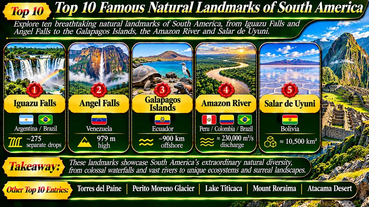
South America's most famous natural landmarks include the tallest waterfall, the largest salt flat and the river carrying more water than any other on Earth.
The continent stretches from the Caribbean coast to the icy tip of Patagonia, and the Andes run along its western side for thousands of kilometres. Between the mountains and the Atlantic lie the Amazon basin, ancient table-top plateaus and vast grasslands. This variety of landscapes means that few places on Earth pack so many natural records into a single continent [1].
This Finepedia list picks ten landmarks for their scale, beauty, scientific importance and fame among travellers. Several are protected as national parks or UNESCO World Heritage Sites. Figures such as heights and areas follow the main geographic references as of November 2026 and are rounded where sources differ.
Key Facts
Here is a quick overview of the ten landmarks, with their country and one standout figure or feature for each.
South American Landmarks at a Glance
| Rank | Name | Location/Country | Key figure | Notable fact |
|---|---|---|---|---|
| 1 | Iguazu Falls | Argentina and Brazil | Roughly 275 separate drops | Largest waterfall system in the world |
| 2 | Angel Falls | Venezuela | 979 m high | Tallest uninterrupted waterfall on Earth |
| 3 | Galapagos Islands | Ecuador | About 900 km offshore | Inspired Darwin's theory of evolution |
| 4 | Amazon River | Peru, Colombia, Brazil | Up to about 230,000 cubic m per second | Greatest river discharge in the world |
| 5 | Salar de Uyuni | Bolivia | About 10,500 square km | Largest salt flat on Earth |
| 6 | Torres del Paine | Chile | Granite towers about 2,500 m high | Patagonia's best-known national park |
| 7 | Perito Moreno Glacier | Argentina | Ice front about 74 m above the lake | Famous for dramatic ice-dam ruptures |
| 8 | Lake Titicaca | Bolivia and Peru | 3,812 m above sea level | South America's largest lake |
| 9 | Mount Roraima | Venezuela, Brazil, Guyana | 2,810 m summit | Table-top mountain with ancient rocks |
| 10 | Atacama Desert | Chile | Some areas get 1 to 3 mm of rain a year | Driest non-polar desert on Earth |
1. Iguazu Falls
Iguazu Falls lies on the Iguazu River along the border between Argentina's Misiones province and the Brazilian state of Parana. Together the falls form the largest waterfall system in the world, split by rocks and islands into roughly 275 separate drops spread across a wide horseshoe [2].
About half of the river's flow pours into a narrow chasm called the Devil's Throat, which is around 80 to 90 metres wide and 70 to 80 metres deep, and the national border runs right through it [2]. Walkways on both sides take visitors close to the water: the Argentine side offers trails above and below the falls, while the Brazilian side gives the best panoramic view.
The name comes from Guarani or Tupi words meaning "big water." The Spanish explorer Alvar Nunez Cabeza de Vaca recorded the falls in 1541. Today they are protected by Iguazu National Park in Argentina and Iguacu National Park in Brazil, inscribed on the UNESCO World Heritage List in 1984 and 1986 [3].
2. Angel Falls
Angel Falls in Venezuela is the world's tallest uninterrupted waterfall. Water plunges about 979 metres from the edge of Auyan-tepui, a flat-topped mountain, with an unbroken main drop of around 807 metres [4]. The falls lie deep in Canaima National Park, which is reached mainly by small aircraft and river boats.
The waterfall takes its English name from the American aviator Jimmie Angel, who flew over it in 1933 and later crash-landed his plane on top of Auyan-tepui in 1937. In the Pemon language it is known as Kerepakupai Vena, meaning roughly "waterfall of the deepest place" [4].
Related: Top 10 Rarest Rock Formations in the World
Canaima National Park, a UNESCO World Heritage Site since 1994, covers about three million hectares of tepuis, savannah and rainforest [5]. During the dry season the falls can shrink to a thin ribbon, and much of the water turns to mist before reaching the bottom, so most visitors go in the wetter months when boats can travel upriver.
3. Galapagos Islands
The Galapagos Islands are a chain of volcanic islands scattered across the eastern Pacific, about 900 kilometres west of mainland Ecuador. They straddle the equator, and the cold and warm ocean currents that meet there support a mix of wildlife found nowhere else [6].
The islands are famous for endemic species such as giant tortoises, marine iguanas, flightless cormorants and many kinds of finch. Charles Darwin visited in 1835 aboard HMS Beagle, and the differences he noticed between animals on different islands later fed into the ideas on natural selection that made him famous [6]. The archipelago takes its name from an old Spanish word for tortoise.
Ecuador protects the islands as a national park and marine reserve, and they were among the first sites placed on the UNESCO World Heritage List in 1978 [7]. Strict visitor rules, licensed guides and limits on boat itineraries are used to protect fragile ecosystems from the pressure of tourism and introduced species.
4. Amazon River
The Amazon River rises in the Andes of Peru and flows across Colombia and Brazil to the Atlantic Ocean. It is the largest river in the world by volume, discharging roughly 215,000 to 230,000 cubic metres of water per second, more than the next seven largest independent rivers combined [8].
Its length is usually given as about 6,400 kilometres, although some studies measure it at over 7,000 kilometres, which keeps alive a long debate with the Nile over which river is longest. The Amazon basin covers about 7 million square kilometres, the largest drainage basin on the planet, and most of it is covered by the Amazon rainforest [8].
No bridge crosses the main river along its entire length, mainly because it flows through thinly populated rainforest with few roads. At Manaus, the dark waters of the Rio Negro meet the pale Solimoes and flow side by side for kilometres without mixing, a sight known as the Meeting of Waters. The river supports pink river dolphins, giant arapaima fish and thousands of other species.
5. Salar de Uyuni
Salar de Uyuni in southwestern Bolivia is the largest salt flat on Earth, covering about 10,500 square kilometres at an altitude of roughly 3,656 metres in the Andes [9]. It formed as several prehistoric lakes slowly dried out, leaving a crust of salt several metres thick.
Related: Top 10 Most Breathtaking Desert Landscapes
The surface is astonishingly flat, varying by less than one metre in height across its whole area. That flatness, together with clear skies, makes it useful for calibrating satellite instruments. After rain, a thin sheet of water turns the salt into a giant mirror that reflects the sky, creating one of South America's most photographed scenes [9].
Beneath the crust lies brine rich in lithium, and Bolivia is believed to hold a large share of the world's known lithium resources. The salar is also a breeding area for flamingos. Visitors usually cross it on multi-day jeep tours from the town of Uyuni, stopping at salt hotels and islands covered in giant cacti.
6. Torres del Paine
Torres del Paine National Park in Chilean Patagonia is named after three sharp granite towers that rise to around 2,500 metres above sea level. Nearby stand the Cuernos del Paine, or Horns of Paine, whose pale granite is capped by dark sedimentary rock [10].
The park, established in 1959, covers about 181,000 hectares of peaks, ice fields, lakes and fast rivers. It sits on the boundary between Magellanic forests and the Patagonian steppe, and wildlife includes guanacos, foxes, condors and pumas. UNESCO named it a Biosphere Reserve in 1978 [10].
Torres del Paine is one of the most visited parks in Chile, drawing around a quarter of a million visitors a year. Hikers come for multi-day routes such as the W trek and the longer circuit around the massif, passing turquoise lakes and the huge Grey Glacier. Strong winds and rapidly changing weather are part of the experience.
7. Perito Moreno Glacier
The Perito Moreno Glacier in Los Glaciares National Park, Argentina, is one of the most famous glaciers in the world. About 30 kilometres long, it flows from the Southern Patagonian Ice Field into Lake Argentino, where its front is around 5 kilometres wide and rises about 74 metres above the water [11].
Related: Grand Canyon: A Geological Marvel Carved by the Colorado River
The glacier is famous for its cycle of damming and rupture. As it advances, it can block an arm of the lake called Brazo Rico. Water then builds up behind the ice until it breaks through in a dramatic collapse. Ruptures have been recorded many times since 1917, at intervals ranging from about a year to more than a decade [11].
The glacier is named after the explorer Francisco Moreno, who studied the region in the nineteenth century. Los Glaciares National Park has been a UNESCO World Heritage Site since 1981 [12]. Walkways near El Calafate let visitors watch huge chunks of ice crash into the lake, and guided hikes cross the glacier's surface.
8. Lake Titicaca
Lake Titicaca lies high in the Andes on the border between Bolivia and Peru. At about 3,812 metres above sea level and with an area of around 8,370 square kilometres, it is the largest lake in South America and is often described as the highest navigable lake in the world [13].
The lake held great religious importance for the Inca, who regarded the Isla del Sol, or Island of the Sun, as a sacred place connected to the origins of their civilisation. Ruins and terraces on the island still attract pilgrims and tourists [13].
Titicaca is also known for the floating islands of the Uros people, built from layers of totora reeds that must be added continuously as the lower layers rot. The lake is home to rare wildlife such as the large Titicaca water frog and the flightless Titicaca grebe, both found almost nowhere else [13].
9. Mount Roraima
Mount Roraima is a huge table-top mountain, or tepui, at the point where Venezuela, Brazil and Guyana meet. Sheer cliffs 400 to 1,000 metres high surround its flat summit, which reaches about 2,810 metres at its highest point [14].
The mountain is made of sandstone about 1.7 to 2 billion years old, among the oldest exposed rocks on Earth. Heavy rain has carved the summit into strange black rock formations, pools and crystal-filled hollows, and its isolation has produced plants and animals found nowhere else [14].
Related: Top 10 Breathtaking Canyons of the World
Roraima was first climbed by a British expedition in 1884, and accounts of its mysterious plateau are often said to have inspired Arthur Conan Doyle's novel The Lost World. Today it is a popular multi-day trek from the Venezuelan side, where a natural ramp allows hikers to reach the summit without technical climbing.
10. Atacama Desert
The Atacama Desert stretches about 1,600 kilometres along the Pacific coast of northern Chile. It is the driest non-polar desert in the world, and some weather stations there have never recorded rain. Average rainfall is around 15 millimetres a year, but some places receive only 1 to 3 millimetres [15].
Its extreme dryness comes from a double rain shadow created by the Andes and the Chilean Coast Range, combined with the cold Humboldt Current offshore. Scientists use parts of the desert to test equipment for Mars missions because its soils resemble Martian conditions [15]. In rare wet years, the southern Atacama bursts into colour in an event called the flowering desert.
The clear, dry air also makes the Atacama one of the best places on Earth for astronomy. The European Southern Observatory runs major observatories there, including the Very Large Telescope at Paranal and the ALMA radio telescope on the Chajnantor plateau [15]. The oasis town of San Pedro de Atacama is the main base for visiting salt lakes, geysers and moon-like valleys.
Conclusion
South America's natural landmarks range from roaring waterfalls and endless salt to ancient mountains and the driest desert outside the poles. Each tells part of the story of how the Andes, the Amazon and the oceans have shaped the continent.
Many of these places are protected, but they still face pressure from climate change, tourism and resource extraction. Visiting responsibly helps keep them intact for future generations. For more natural wonders, see the mighty waterfalls of the world, the amazing salt flats of the world, the famous glaciers of the world, the longest rivers in the world and the amazing animals of the Amazon rainforest.
- ^ [1] "South America". Wikipedia. Wikipedia: South America
- ^ [2] "Iguazu Falls". Wikipedia. Wikipedia: Iguazu Falls
- ^ [3] "Iguazu National Park". UNESCO World Heritage Centre. UNESCO: Iguazu National Park
- ^ [4] "Angel Falls". Wikipedia. Wikipedia: Angel Falls
- ^ [5] "Canaima National Park". UNESCO World Heritage Centre. UNESCO: Canaima National Park
- ^ [6] "Galapagos Islands". Wikipedia. Wikipedia: Galapagos Islands
- ^ [7] "Galapagos Islands". UNESCO World Heritage Centre. UNESCO: Galapagos Islands
- ^ [8] "Amazon River". Wikipedia. Wikipedia: Amazon River
- ^ [9] "Salar de Uyuni". Wikipedia. Wikipedia: Salar de Uyuni
- ^ [10] "Torres del Paine National Park". Wikipedia. Wikipedia: Torres del Paine
- ^ [11] "Perito Moreno Glacier". Wikipedia. Wikipedia: Perito Moreno Glacier
- ^ [12] "Los Glaciares National Park". UNESCO World Heritage Centre. UNESCO: Los Glaciares
- ^ [13] "Lake Titicaca". Wikipedia. Wikipedia: Lake Titicaca
- ^ [14] "Mount Roraima". Wikipedia. Wikipedia: Mount Roraima
- ^ [15] "Atacama Desert". Wikipedia. Wikipedia: Atacama Desert




















Discussion
Log in with