






 By
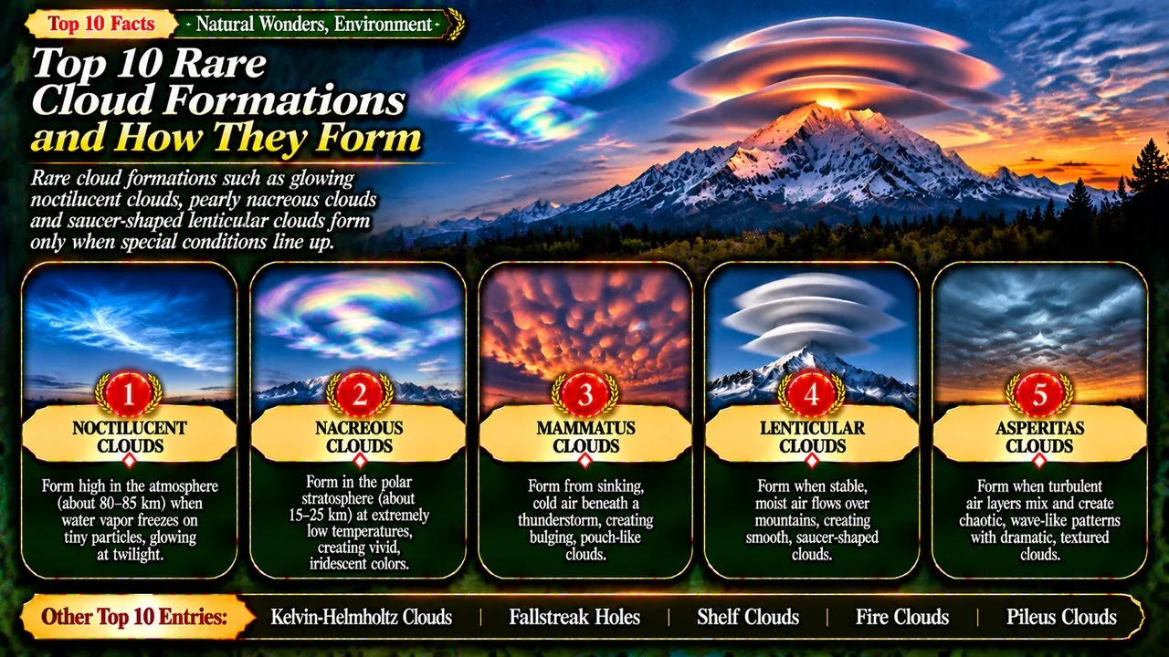
Rare cloud formations such as glowing noctilucent clouds, pearly nacreous clouds and saucer-shaped lenticular clouds form only when special conditions line up.
Most clouds are familiar: white puffs on a summer day, grey sheets before rain or towering storm clouds. Every so often, though, the sky produces something stranger, such as clouds that glow after dark, shine like mother of pearl, curl like breaking waves or hang down in pouches. Each one tells a story about temperature, moisture and wind high above the ground.
This Finepedia guide, written in November 2026, takes its topic from a Listverse list of rare cloud formations [26]. The selection, order and wording are our own. We kept six of its entries, left out man-made mushroom clouds and the roll cloud, which Finepedia already covers through Australia's Morning Glory, and added asperitas, fallstreak holes, fire clouds and pileus. Names and definitions follow the World Meteorological Organization's International Cloud Atlas, the official guide to cloud types.
Key Facts
This table sums up the ten cloud formations, where they form and what makes each one unusual.
Rare Cloud Formations at a Glance
| Rank | Name | Typical height | What makes it special |
|---|---|---|---|
| 1 | Noctilucent Clouds | About 80 km, in the mesosphere | Highest clouds, glowing after sunset |
| 2 | Nacreous Clouds | About 15 to 25 km, in the stratosphere | Brilliant mother-of-pearl colours in polar winter |
| 3 | Mammatus Clouds | Under storm anvils | Pouches hanging from the base of a cloud |
| 4 | Kelvin-Helmholtz Clouds | Various | Curls like breaking ocean waves |
| 5 | Lenticular Clouds | Over and near mountains | Smooth lens or saucer shapes |
| 6 | Asperitas Clouds | Low and middle levels | A rough, sea-like cloud base; named in 2017 |
| 7 | Fallstreak Holes | Middle levels | Round holes punched in a cloud layer |
| 8 | Shelf Clouds | Low, at a storm's leading edge | A dark, menacing arch ahead of a storm |
| 9 | Fire Clouds | Above wildfires and volcanoes | Clouds made by heat from fires |
| 10 | Pileus Clouds | On top of growing storm clouds | A smooth cap that lasts only minutes |
1. Noctilucent Clouds
Noctilucent clouds are the highest clouds in the Earth's atmosphere. They form in the mesosphere at about 80 km above the ground, far above the weather and the height at which airliners fly [1][2]. Their name means night shining in Latin. They are too faint to see in daylight, but after sunset they can still catch sunlight while the ground below is dark, so they glow with a silvery blue colour against the twilight sky [1][3].
They are made of tiny ice crystals that form on specks of dust, probably from meteors burning up in the atmosphere [3][2]. The mesosphere is extremely dry, so the crystals can only form when the temperature falls below about minus 120 C, which happens there in summer [1][3]. They are usually seen in summer at latitudes between about 50 and 70 degrees north or south [1].
The first confirmed reports came in 1885, two years after the huge eruption of Krakatoa [1]. NASA's AIM satellite has studied them from space, and research suggests that rising methane and water vapour from rocket exhaust can help them form [1][2]. Clouds at the edge of space take first place.
2. Nacreous Clouds
Known as mother-of-pearl clouds for their sheen, nacreous clouds are among the most beautiful sights in the sky. They form in the stratosphere at about 15 to 25 km up, well above ordinary clouds [4][6]. When the Sun is a few degrees below the horizon, they glow with vivid, shifting colours like the inside of a seashell [5][6].
They need extreme cold. Temperatures must fall below about minus 78 C, which happens only in the polar stratosphere during winter [4][6]. The colours come from sunlight being diffracted by tiny, similarly sized ice crystals [5]. They are most common over Antarctica but have also been seen in the Arctic, Scandinavia, Alaska, Canada and Scotland [5][6].
Related: The Science Behind Auroras: How Solar Winds Create Colorful Skies
Their beauty has a darker side. Polar stratospheric clouds provide surfaces for chemical reactions that release chlorine, which destroys ozone, and they play a key part in forming the ozone hole [4][6]. In early 2016, rare sightings over England and Scotland delighted cloud spotters, and some people mistook the colours for the northern lights [6]. A cloud that is both dazzling and damaging earns second place.
3. Mammatus Clouds
Mammatus clouds look like rows of rounded pouches hanging from the underside of a cloud. Their name comes from the Latin mamma, meaning udder or breast [7][8]. The International Cloud Atlas lists them as a supplementary feature rather than a separate cloud type [7][8].
They usually form beneath the anvil of a cumulonimbus storm cloud, where cold air laden with ice and water sinks instead of rising [7][9]. As it sinks, the cloud particles evaporate and cool the air, which makes the pockets sink further and gives the base its lumpy look [7]. Individual pouches are typically around 1 to 3 km across, and a field of them can stretch for hundreds of kilometres [7].
Mammatus often appear with severe thunderstorms, but they do not produce severe weather themselves, and they can also form with weaker storms [9][7]. Pilots are warned to avoid them because they mark strong turbulence [7]. A cloud that looks threatening but rarely harms anyone takes third place.
4. Kelvin-Helmholtz Clouds
Kelvin-Helmholtz clouds look like a row of ocean waves breaking across the sky. The International Cloud Atlas calls this feature fluctus, a short-lived wave formation in the form of curls, usually on the top of a cloud [11]. They can appear with several cloud types, including cirrus, altocumulus and stratus [11].
The waves form when two layers of air move at different speeds, one sliding quickly over a slower layer below. This wind shear makes the boundary between them unstable, and it rolls up into curling eddies [10][11]. The effect is named after the physicists Hermann von Helmholtz, who described it in 1868, and William Thomson, later Lord Kelvin, who worked out the mathematics in 1871 [10].
The same instability appears in many other places, from waves on the sea to bands in the clouds of Jupiter and features in the Sun's atmosphere [10]. In the sky the pattern is relatively short-lived, so a clear sighting is a lucky moment [11]. Waves on the sky's own ocean earn fourth place.
5. Lenticular Clouds
Lenticular clouds have smooth, lens-shaped or almond-shaped outlines, and they often look like flying saucers hovering in the sky [12][13]. Their name comes from the Latin word for lentil. Unlike most clouds, they seem to stay in one place even when strong winds are blowing [12].
Related: Top 10 Coldest Places in the World
They form when a stream of moist, stable air crosses a mountain or hill and sets up a series of standing waves downwind. Where the air rises to the crest of a wave, it cools and its water vapour condenses into cloud. Where it sinks again, the cloud evaporates. Air flows through the cloud while its shape stays fixed [12]. Long strings of them can form along the crests of successive waves, and some show iridescent colours [12][13].
Lenticular clouds have often been mistaken for UFOs [12]. Pilots of powered aircraft avoid them because of turbulence, but glider pilots seek them out to ride the rising air at their leading edge [12]. They usually form near mountains, so many people who live on flat land never see one [12][13]. These sky saucers take fifth place.
6. Asperitas Clouds
Asperitas clouds have a dramatic, rough underside that looks like a stormy sea seen from below the waves [14][15]. The name means roughness in Latin. The cloud base can be smooth or dappled, sometimes dipping into sharp points, and changing light can make the effect look dark and stormy [15]. Despite this, the clouds usually fade away without a storm [14].
Asperitas is the newest feature in the International Cloud Atlas. The story began on 20 June 2006, when Jane Wiggins photographed the clouds from an office building in Cedar Rapids, Iowa, and sent the picture to the Cloud Appreciation Society [14]. Similar photos arrived from around the world, and the society's founder, Gavin Pretor-Pinney, proposed a new name [14][16].
In March 2017 the World Meteorological Organization officially added asperitas as a supplementary feature, the first new cloud formation since cirrus intortus in 1951 [14][16]. It occurs mostly with stratocumulus and altocumulus clouds [15]. A cloud recognised thanks to members of the public earns sixth place.
7. Fallstreak Holes
A fallstreak hole is a large gap, usually round or oval, that appears in a thin layer of altocumulus or cirrocumulus cloud. It is also known as a hole-punch cloud or cavum [17][18]. Wispy streaks of ice often trail down from the middle of the hole, which tends to grow larger over time [18].
Related: Top 10 Most Destructive Typhoons in Recorded History
These holes form in clouds made of supercooled water, droplets that stay liquid below 0 C because nothing has triggered them to freeze [17][18]. Once a few ice crystals appear, they grow quickly by taking water from the droplets around them. The droplets evaporate, the heavier crystals fall, and an open hole is left behind [17].
Aircraft are a common trigger. A 2011 study led by the National Center for Atmospheric Research showed that air expanding and cooling behind propeller tips and over jet wings can freeze droplets, starting the process [19][17]. In some conditions this can even produce snow or rain near airports [19]. Because they look so strange, fallstreak holes have been mistaken for UFOs [17]. Holes punched in the sky earn seventh place.
8. Shelf Clouds
Shelf clouds are flat, wedge-like bands of low cloud fixed to the base of a thunderstorm. With the roll cloud, it is one of the two main types of arcus cloud [20][21]. The International Cloud Atlas describes arcus as a dense, horizontal roll that, when large, looks like a dark, menacing arch [21].
Shelf clouds form along the gust front of a storm. Cold air from the storm's downdraft spreads out along the ground and pushes under the warm, moist air ahead of it. As the warm air is lifted, its moisture condenses to form the shelf [20]. Rising air can often be seen at the front edge, while the underside may look turbulent and torn [20].
An approaching shelf cloud can look like a wall of cloud, and people sometimes confuse it with a wall cloud, the feature from which tornadoes can form. However, shelf clouds usually sit at the leading edge of a storm, while wall clouds are usually found farther back [20]. The arrival of a shelf cloud often means strong gusts and heavy rain are minutes away [20][21]. The dramatic herald of a storm earns eighth place.
9. Fire Clouds
Fire clouds form above large wildfires and volcanic eruptions. The International Cloud Atlas calls them flammagenitus, clouds that develop because of convection driven by heat from fires or volcanic activity [22][23]. They are also known as pyrocumulus clouds [22]. To earn the name, a cloud must clearly have started from a local natural heat source and must be made at least partly of liquid water [23].
The intense heat makes the air rise rapidly. Moisture in the air, plus water released from burning plants or volcanic gases, condenses on particles of smoke and ash to build a dense, towering cloud [22]. Such clouds contain severe turbulence, and the strong gusts they create at the surface can make a wildfire much worse [22].
Related: Top 25 Interesting Facts About the Solar System
If the fire is big enough, the cloud can grow into a full thunderstorm, called cumulonimbus flammagenitus. It can then produce lightning, which may start new fires far from the original blaze [22][23]. Large fire clouds over volcanic eruptions can also crackle with lightning, possibly because of the turbulence and charged ash inside them [22]. A cloud made by the fire beneath it earns ninth place.
10. Pileus Clouds
A pileus is a small, smooth cap or hood of cloud that sits on top of a rising cumulus or cumulonimbus cloud. Its name is Latin for cap, and it is also called a cap cloud or scarf cloud [24][25]. Several pilei can sometimes be seen stacked on top of each other [24][25].
It forms when a strong updraft in the cloud below pushes up a layer of moist air above it. That air cools to its dew point and condenses into a thin, flat cap [24]. Pileus clouds usually last only a few minutes, because the growing cloud below soon rises through the cap and absorbs it [24]. Sunlight passing through the cap's tiny, evenly sized droplets can create beautiful iridescent colours [24].
A pileus is a sign that the cloud beneath it is growing quickly and has plenty of moisture, so it can warn that a thunderstorm is developing [24]. Pilei can also form above volcanic ash clouds and fire clouds [24]. A brief, colourful cap on a growing storm closes our list.
Conclusion
From noctilucent clouds at the edge of space to the pileus caps that warn of storms, these ten formations show how much variety the sky can hold. Each one depends on a particular mix of temperature, moisture and moving air, which is why they are rare.
Many of these clouds were first understood thanks to careful observers, from early sky watchers to members of the public with cameras. For more of nature's strange local events, see Top 10 Unusual Local Phenomena Around the World and Top 10 Earth Extremes and Records.
- ^ [1] "Noctilucent cloud". Wikipedia. Wikipedia
- ^ [2] "High, Dry, and Rare in the Sky". NASA Earth Observatory. NASA
- ^ [3] "Noctilucent clouds (polar mesospheric clouds)". WMO International Cloud Atlas. WMO
- ^ [4] "Polar stratospheric cloud". Wikipedia. Wikipedia
- ^ [5] "Nacreous clouds". WMO International Cloud Atlas. WMO
- ^ [6] "Nacreous clouds". Royal Meteorological Society. Royal Meteorological Society
- ^ [7] "Mammatus cloud". Wikipedia. Wikipedia
- ^ [8] "Mamma". WMO International Cloud Atlas. WMO
- ^ [9] "Mammatus Clouds". National Weather Service glossary. NOAA National Weather Service
- ^ [10] "Kelvin-Helmholtz instability". Wikipedia. Wikipedia
- ^ [11] "Fluctus". WMO International Cloud Atlas. WMO
- ^ [12] "Lenticular cloud". Wikipedia. Wikipedia
- ^ [13] "Lenticularis". WMO International Cloud Atlas. WMO
- ^ [14] "Asperitas (cloud)". Wikipedia. Wikipedia
- ^ [15] "Asperitas". WMO International Cloud Atlas. WMO
- ^ [16] "Asperitas: Our new cloud became official in March 2017". Cloud Appreciation Society. Cloud Appreciation Society
- ^ [17] "Fallstreak hole". Wikipedia. Wikipedia
- ^ [18] "Cavum". WMO International Cloud Atlas. WMO
- ^ [19] "Flights can inadvertently generate rain and snow near airports". NCAR and UCAR News. UCAR
- ^ [20] "Arcus cloud". Wikipedia. Wikipedia
- ^ [21] "Arcus". WMO International Cloud Atlas. WMO
- ^ [22] "Flammagenitus cloud". Wikipedia. Wikipedia
- ^ [23] "Flammagenitus". WMO International Cloud Atlas. WMO
- ^ [24] "Pileus (meteorology)". Wikipedia. Wikipedia
- ^ [25] "Pileus". WMO International Cloud Atlas. WMO
- ^ [26] "10 Rare Cloud Formations". Listverse. Topic reference on Listverse



















Discussion
Log in with