





 By
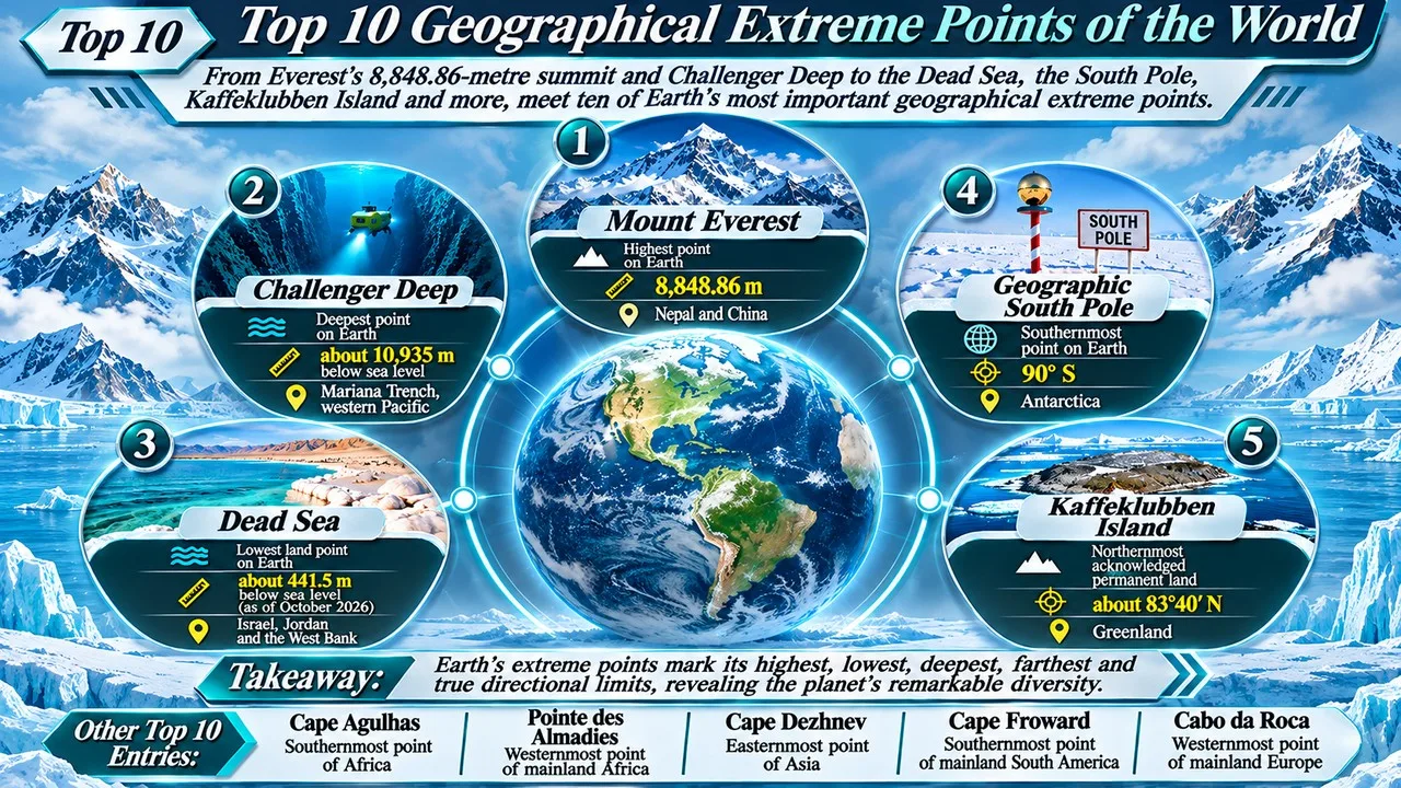
Earth's extreme points run from Everest's 8,848.86-metre summit to Challenger Deep, 10,935 metres below the Pacific. Between those two marks lie the lowest land surface, the poles, and the farthest tips of the continents, each defined by careful surveys rather than by travel slogans [1][2].
An extreme point is a place that is the most northerly, southerly, easterly, westerly, highest or lowest in a given area. On a round planet the eastern and western limits depend on where one starts measuring, so this list uses widely accepted extremes of the whole Earth and of the main continental landmasses. Temporary gravel banks, disputed islets and tourist towns that stand near, but not at, a true extreme are noted rather than treated as the record [1].
Heights and depths below are given as of November 2026. The Dead Sea's shore keeps falling, so its figure is dated to October 2026. Everest's height is the 8,848.86-metre value agreed by China and Nepal in 2020 [1][3].
Key Facts
The table lists each extreme, its location and the measurement that makes it a record.
Geographical Extreme Points at a Glance
| Rank | Place | Location | Extreme | Notable fact |
|---|---|---|---|---|
| 1 | Mount Everest | Nepal and China | 8,848.86 metres above sea level | Highest point on Earth's surface |
| 2 | Challenger Deep | Mariana Trench, western Pacific | About 10,935 metres below sea level | Deepest known point in the ocean |
| 3 | Dead Sea | Israel, Jordan and the West Bank | About 441.5 metres below sea level (October 2026) | Lowest land elevation on Earth |
| 4 | Geographic South Pole | Antarctica | 90 degrees south | Southernmost point on the planet |
| 5 | Kaffeklubben Island | Greenland, Denmark | About 83 degrees 40 minutes north | Northernmost acknowledged permanent land |
| 6 | Cape Agulhas | South Africa | About 34 degrees 50 minutes south | Southernmost point of the African continent |
| 7 | Pointe des Almadies | Senegal | About 17 degrees 32 minutes west | Westernmost point of mainland Africa |
| 8 | Cape Dezhnev | Chukotka, Russia | About 169 degrees 40 minutes west | Easternmost point of mainland Asia |
| 9 | Cape Froward | Chile | About 53 degrees 54 minutes south | Southernmost point of mainland South America |
| 10 | Cabo da Roca | Portugal | About 9 degrees 30 minutes west | Westernmost point of continental Europe |
1. Mount Everest
Mount Everest, known as Sagarmatha in Nepal and Qomolangma in Tibet, is the highest point on Earth's surface. A joint survey by China and Nepal, announced in 2020, set the height at 8,848.86 metres above sea level, a figure that includes the snow cap on the summit [3]. The mountain stands on the border of the two countries, in the Mahalangur range of the Himalaya, and its summit is the most northerly of the world's 8,000-metre peaks only in the sense that it is the high point of that chain; what matters here is altitude, not latitude.
The peak was first climbed by Edmund Hillary and Tenzing Norgay on 29 May 1953. It now attracts hundreds of climbers in a typical season, which has brought both better measurements and serious questions about crowding, waste and risk. The height can change slightly as snow depth varies and as the crust continues to rise in the collision between India and Eurasia.
For a wider view of high summits, see the highest mountains in the world and the standalone Mount Everest page [3].
2. Challenger Deep
Challenger Deep is the deepest known point in the ocean, in the southern end of the Mariana Trench in the western Pacific, south-west of Guam. Recent high-precision soundings and descents, including measurements recognised by Guinness World Records, put the depth at about 10,935 metres below sea level [2][4]. The exact number varies by a few metres between expeditions, which is why the figure is given as an approximate value.
The site is named after HMS Challenger, whose nineteenth-century sounding first showed that this part of the trench was extraordinarily deep. Manned and unmanned vehicles have since reached the bottom, including the 1960 descent of Trieste and later dives by James Cameron and by Victor Vescovo's Five Deeps expedition.
Related: Top 25 Interesting Facts About Earth
Pressure at the bottom is more than 1,000 times that at the sea surface. Unlike a mountain summit, Challenger Deep cannot be visited without a specialised submersible, but it is as much a geographical extreme as Everest is [2][4].
3. Dead Sea
The Dead Sea, shared by Israel, Jordan and the West Bank, is the lowest exposed land on Earth. Its shoreline has been falling for decades as less water arrives from the Jordan River and as minerals are extracted from the basin. In 2025 the surface stood about 439.8 metres below sea level; by 4 October 2026 it was about 441.5 metres below mean sea level [5][6].
The lake is also one of the saltiest large water bodies on the planet, which is why swimmers float so easily. The same dryness that produces the low elevation is shrinking the sea and opening sinkholes along parts of the coast, so the record is a moving one. Older textbooks that quote 418 or 430 metres below sea level are simply out of date.
The Dead Sea is a tourist destination and a mineral resource, but it is first of all a geographical extreme: no open stretch of dry land on Earth sits lower [5][6].
4. Geographic South Pole
The Geographic South Pole is the southernmost point on Earth, at 90 degrees south, where every direction points north. It lies on the Antarctic ice sheet, not on bare rock. The ice is several thousand metres thick, and the surface elevation is about 2,800 metres above sea level, which makes the pole a high, cold plateau rather than a sea-level mark [1].
The pole was first reached by Roald Amundsen's party on 14 December 1911. The United States' Amundsen-Scott South Pole Station now stands nearby, and because the ice moves, the marked ceremonial pole has to be repositioned each year to stay on the true geographic point.
There is no land farther south. Ice shelves and the coast of the Antarctic continent all lie at lower latitudes, so the pole is the one unambiguous southern extreme of the planet [1].
5. Kaffeklubben Island
Kaffeklubben Island, off the northern coast of Greenland, is widely accepted as the northernmost permanent land on Earth, at about 83 degrees 40 minutes north, a short way north of Cape Morris Jesup on the mainland [1]. The small, barren island was named by the Danish explorer Eigil Knuth; the name means "Coffee Club".
Related: Top 10 Most Dangerous Mountains in the World
Claims of land still farther north usually refer to gravel banks or sandbars, such as Oodaaq, that appear and disappear as ice and storms move sediment. Those features are not lasting islands, so most geographical lists keep the record with Kaffeklubben [1].
The island is uninhabited and can be reached only by special expedition. Alert, on Ellesmere Island in Canada, is the northernmost permanently inhabited place, but it lies well south of this tip of Greenland [1].
6. Cape Agulhas
Cape Agulhas, in South Africa's Western Cape, is the southernmost point of the African continent, at about 34 degrees 50 minutes south [1]. It is often confused with the Cape of Good Hope, which is more famous but lies about 150 kilometres to the west and slightly to the north. A cairn and a lighthouse mark the tip, and maps often treat it as the divide between the Atlantic and Indian Oceans.
The name comes from the Portuguese word for needles, a reference to the jagged reefs and to the fact that the compass needle showed little or no magnetic deviation there in the age of sail. The waters off the cape are known for rough seas where currents meet.
For a clean continental extreme, Agulhas is the point that matters. Good Hope remains the historic landmark of the sea route, but it is not Africa's southern tip [1].
7. Pointe des Almadies
Pointe des Almadies, on the Cap-Vert peninsula just north of Dakar, Senegal, is the westernmost point of mainland Africa, at about 17 degrees 32 minutes west [1]. The headland sits on a rocky coast with beaches, hotels and a view over the Atlantic, and it is one of the easier extremes on this list to visit.
Related: Top 10 Highest Bridges in the World
Because Africa's west coast runs almost north-south for a long distance, the title of westernmost point is easy to get wrong. The Cap-Vert peninsula juts farther west than the rest of the Sahel and Guinea coasts, which is why the record is in Senegal and not farther south in Sierra Leone or Liberia [1].
The point is a convenient reminder that not every extreme is remote. Some, like this one, lie on the edge of a capital city [1].
8. Cape Dezhnev
Cape Dezhnev, at the eastern end of Russia's Chukchi Peninsula, is the easternmost point of mainland Asia, at about 169 degrees 40 minutes west [1]. It looks across the Bering Strait to Alaska's Cape Prince of Wales, mainland North America's westernmost point. The two capes are only about 80 kilometres apart.
The cape is named for the Russian explorer Semyon Dezhnev, who sailed around it in 1648, long before Vitus Bering's better-known voyage. A lighthouse and a monument stand on the headland, near the village of Uelen. In terms of longitude, this is also close to the 180th meridian, so the date line has to bend to keep eastern Russia and Alaska on different calendar days.
For anyone travelling east across the whole of Eurasia, Cape Dezhnev is the end of the road [1].
9. Cape Froward
Cape Froward, on the Brunswick Peninsula in southern Chile, is the southernmost point of mainland South America, at about 53 degrees 54 minutes south [1]. It lies on the north shore of the Strait of Magellan and is marked by a large steel cross. The name goes back to Sir Thomas Cavendish, who found the weather there contrary, or "froward", in 1587.
Popular geography sometimes gives this title to Ushuaia in Argentina, or to Cape Horn. Ushuaia is the southernmost city of any size, but it is not the southernmost land of the continent. Cape Horn is farther south still, yet it stands on an island in the Tierra del Fuego archipelago, not on the mainland [1].
Related: Top 10 Tallest TV and Observation Towers
Cape Froward is windy, lightly visited and easy to misidentify, which is why a precise list has to separate the mainland extreme from nearby islands and towns [1].
10. Cabo da Roca
Cabo da Roca, in the Sintra-Cascais region west of Lisbon, is the westernmost point of continental Europe, at about 9 degrees 30 minutes west [1]. A lighthouse, a stone monument and a certificate office stand on the cliffs, which drop to the Atlantic and attract large numbers of visitors. The cape was already a landmark for Portuguese sailors in the Age of Discovery.
Iceland, the Azores and Ireland all lie farther west, but they are islands. On the European mainland, no point outruns this headland of Portugal. A well-known inscription at the site, drawn from the poet LuÃs de Camões, describes the cape as the place where the land ends and the sea begins.
The cliffs are part of a protected landscape, and the view is one of the reasons Cabo da Roca is as popular as it is precise. Among the extremes on this list, it is second only to Pointe des Almadies in how easily a traveller can stand on the exact spot [1].
Conclusion
These ten points fix the edges of the solid Earth and of its main continents: the highest summit, the deepest seafloor, the lowest shore, the poles of latitude and the tips of Africa, Asia, South America and Europe. A few famous nearby names, such as the Cape of Good Hope, Cape Horn and Ushuaia, are often mistaken for the true marks and are left off for that reason.
Surveys improve, ice and water levels change, and the Dead Sea in particular is a moving target. The figures here are those accepted as of November 2026. For more on high ground, see the highest mountains in the world.
- ^ [1] "Extreme points of Earth". Wikipedia. Wikipedia: Extreme points of Earth
- ^ [2] "Deepest point in the sea". Guinness World Records. Guinness World Records: Deepest point in the sea
- ^ [3] "Mount Everest". Wikipedia. Wikipedia: Mount Everest
- ^ [4] "Challenger Deep". Wikipedia. Wikipedia: Challenger Deep
- ^ [5] "Dead Sea". Wikipedia. Wikipedia: Dead Sea
- ^ [6] "Dead Sea elevation: how far below sea level is it?". Dead Sea.com. Dead Sea.com: Dead Sea elevation



















Discussion
Log in with