

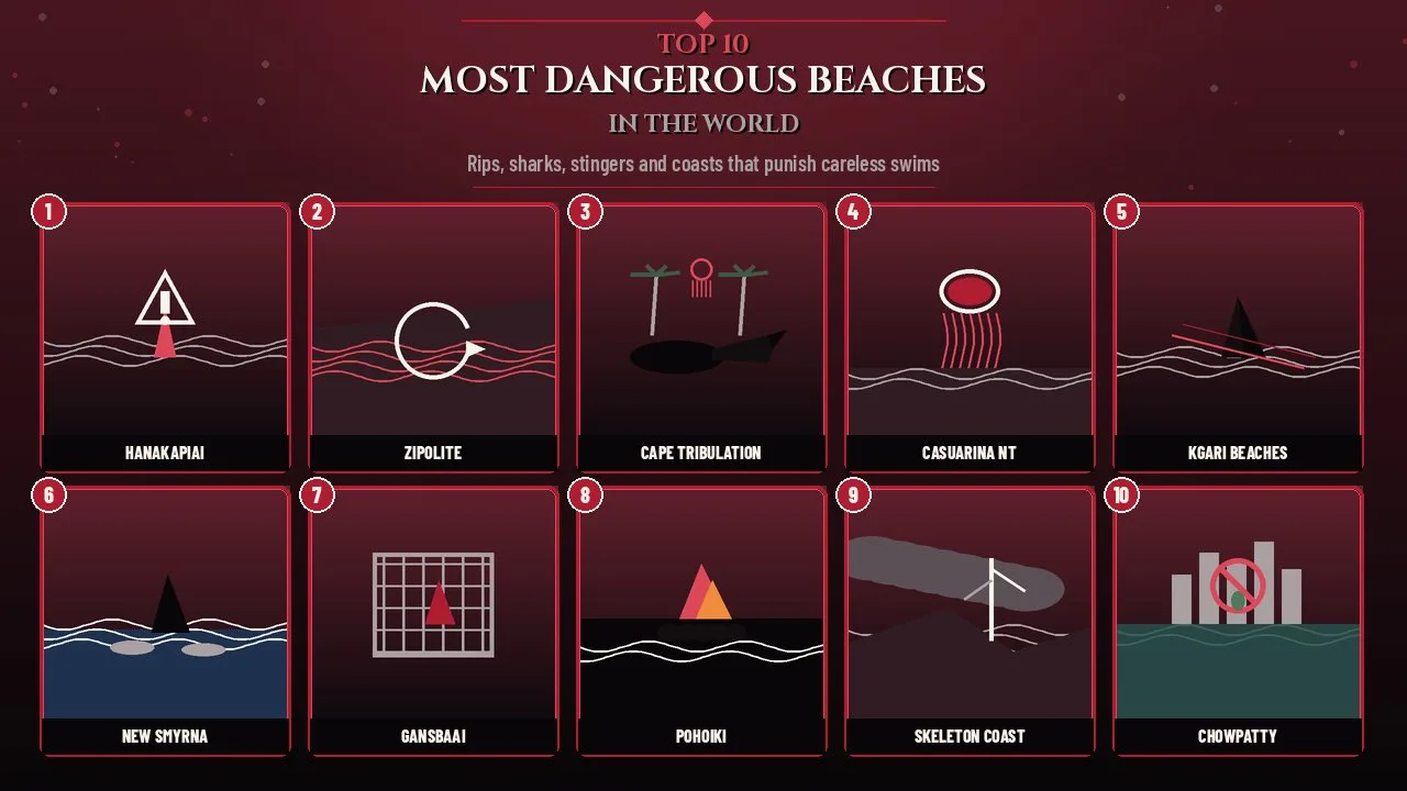
The most dangerous beaches in the world mix lethal rips, sharks, box jellyfish, crocodiles and foul water with postcard views that still lure millions.
A beach can look calm from the car park and still hide a current that pulls hard offshore, a juvenile shark hunting baitfish in the shore break, or a near-invisible box jellyfish in warm tropical water. Beauty and risk travel together. Millions of people visit coastal parks, surf towns and tropical resorts every year without checking local warnings, and a small share of those visits end in hospital or worse.
This 2026 Finepedia guide ranks ten beaches and coastal stretches where the documented hazards are unusually severe, well evidenced, or frequently underestimated by visitors. The list mixes remote trail beaches with famous tourist strips. Every entry includes a Quick Facts table, its background, what makes it dangerous, and why the risk still matters for travellers who plan to swim, surf, hike or simply stand at the waterline.
If you are also mapping high-risk travel beyond the shoreline, Finepedia's guide to the most dangerous tourist destinations in the world covers broader land and adventure hazards. For calmer city wandering instead of hazard coasts, see Finepedia's guide to the most walkable cities in the world.
How We Chose the Most Dangerous Beaches in the World
Danger on a beach is not a single score. A remote Kauai cove with no lifeguard and a six-mile swim to the next safe landing is dangerous in a different way from a Florida surf town with many non-fatal shark bites, or a Mumbai promenade where the main threat is polluted water rather than waves.
This list uses a clear, tiered method:
- Tier 1, documented lethal hazard for visitors: beaches with peer-reviewed, park-service or health-department evidence of repeated drownings, fatal marine stings, or multi-species wildlife risk that authorities treat as a standing swim warning.
- Tier 2, high-frequency injury or attack reports: places that lead regional or global tallies for shark bites, rescues or related incidents, even when most outcomes are non-fatal.
- Tier 3, severe environmental or coastal hazard: beaches where pollution, volcanic shore conditions, fog-driven shipwreck coasts or sneaker-wave cliffs create clear, sourced visitor risk even when drownings are less statistically dominant.
Within each tier, places with stronger published evidence rank higher. Scenery, Instagram popularity and hotel density were not ranking factors. Where the May 2020 reference list used a vague region (Amazon beaches) or an unclear Hawaiian name (Kilauea Black Sand Beach), this article replaces them with better-documented, named sites and notes the change.
What Counts as a Dangerous Beach?
A dangerous beach, for this guide, is a stretch of sand or rock shoreline where ordinary visitor behaviour (swimming, wading, surfing, hiking to the sand, or standing near the surf line) carries a documented elevated risk of drowning, serious injury, envenomation, infection or wildlife attack compared with typical patrolled resort beaches.
Risk is not the same as inevitability. Many of these places are beautiful, legally open and worth visiting with good judgment. The point of ranking them is not to ban travel, but to match the hazard to the place so readers can decide how close to get to the water.
Hazard Types at a Glance
| Hazard type | Typical places on this list | Why it matters |
|---|---|---|
| Rip currents and heavy surf | Hānakapiʻai, Zipolite, K'gari, Pohoiki | Can pull strong swimmers offshore; remote beaches delay rescue |
| Sharks | New Smyrna Beach, Gansbaai, K'gari | Bite risk varies widely; most Florida bites are non-fatal |
| Box jellyfish and Irukandji | Cape Tribulation, Darwin NT, K'gari | Chironex can cause cardiac arrest; vinegar and CPR matter |
| Crocodiles and other wildlife | Cape Tribulation, K'gari (dingoes) | Estuarine crocs inhabit tropical Australian coasts year-round |
| Pollution and pathogens | Girgaum Chowpatty | Faecal contamination raises illness risk even without waves |
| Fog, cold currents, shipwreck coasts | Skeleton Coast | Benguela Current and fog make swimming and landings unsafe |
At a Glance
| Rank | Beach or coast | Country | Main hazard | Key evidence |
|---|---|---|---|---|
| 1 | Hānakapiʻai Beach | United States (Hawaiʻi) | Rip currents, remote rescue | 29 drownings 1970–2009 (Blay study); later fatalities |
| 2 | Playa Zipolite | Mexico | Strong return currents | Ongoing drownings; "Beach of the Dead" nickname |
| 3 | Cape Tribulation | Australia | Crocs, stingers, cassowaries | Queensland Parks swim/wildlife warnings |
| 4 | Casuarina Beach, Darwin | Australia | Chironex box jellyfish | NT Health stinger season guidance |
| 5 | K'gari (Fraser Island) ocean beaches | Australia | Rips, sharks, stingers | QPWS: do not swim in the ocean |
| 6 | New Smyrna Beach | United States | High shark-bite reports | Volusia County leads Florida ISAF tallies |
| 7 | Gansbaai / Shark Alley | South Africa | Great white habitat | Historic white-shark hotspot; cage diving |
| 8 | Pohoiki Black Sand Beach | United States (Hawaiʻi) | Shore break, currents | 2018 Kīlauea lava beach; swim-at-own-risk |
| 9 | Skeleton Coast | Namibia | Fog, Benguela Current | National park; wrecks; no swimming |
| 10 | Girgaum Chowpatty | India | Pollution | MPCB / media faecal-coliform exceedances |
1. Hānakapiʻai Beach
| Attribute | Details |
|---|---|
| Location | Nā Pali Coast, Kauai, Hawaiʻi, United States |
| Access | About 3.2 km (2 miles) hike on the Kalalau Trail from Kēʻē Beach |
| Main hazards | Powerful rip currents, high surf, no lifeguard, remote rescue |
| Documented drownings | 29 visitor drownings recorded for 1970–2009 (Blay); further deaths since |
| Nearest safe shore if swept out | Roughly six miles along the coast in many accounts |
Origins and History
Hānakapiʻai Beach sits in a deep valley on Kauai's roadless Nā Pali Coast. Hikers reach it on the first major stretch of the Kalalau Trail, a path that has drawn visitors for decades with waterfalls, cliffs and a black-sand cove that appears and disappears with winter surf. The beach looks inviting after a sweaty hike, which is exactly why it has become one of Kauai's most studied drowning sites.
Geoscientist Chuck Blay's peer-reviewed analysis of Kauai nearshore drownings from 1970 to 2009 counted 29 deaths at Hānakapiʻai, all island visitors, with 23 occurring in hazardous winter surf. Later local reporting has documented additional drownings, including cases in 2016, 2018, 2021 and December 2024. A well-known trail sign covered in tally marks is unofficial and should not be treated as a precise death count, but it reflects how strongly the hazard lives in local memory.
Key Features
- No lifeguards and no road access for emergency vehicles to the sand itself.
- Strong rip currents and longshore drift that can push a swimmer west along the cliffs.
- High winter surf that can erase the sandy beach entirely at high tide.
- Bodies of some drowning victims have never been recovered, according to local summaries of the Blay research era.
- The hike itself adds fatigue, heat and stream-crossing risk before anyone touches the ocean.
Significance
Hānakapiʻai is the clearest case on this list of a beautiful, hike-in beach whose danger is documented in formal research rather than folklore. It shows how access and geography multiply risk: once a person is swept offshore, there may be no nearby landing and no quick boat or jet-ski rescue.
Park and trail managers repeatedly warn that even calm-looking days can hide dangerous currents. The safest visit is to enjoy the sand and waterfall, keep children well back from the shore break, and treat the ocean as off-limits for swimming.
Interesting Facts
- Blay's Kauai dataset for 1970–2012 also found Poipu area beaches had more total drownings than Hānakapiʻai, but Hānakapiʻai remains exceptional for a remote trail beach.
- About 75 percent of Kauai ocean drownings in one 2005–2014 window were visitors rather than residents.
- The Kalalau Trail requires careful planning for stream flash floods as well as ocean risk.
- Finepedia's most Instagrammable places guide is a reminder that photogenic coasts often overlap with hazard zones.
2. Playa Zipolite
| Attribute | Details |
|---|---|
| Location | San Pedro Pochutla municipality, Oaxaca, Mexico |
| Nickname | Often called the Beach of the Dead |
| Main hazards | Strong return currents, heavy shore break, steep beach face |
| Lifeguards | Municipal lifeguards operate, but drownings still occur |
| Visitor profile | Backpacker and naturist destination on Mexico's Pacific coast |
Origins and History
Zipolite is a small Pacific beach town south of Puerto Escondido and Mazunte. Its name is debated: some local and tourist accounts link it to death and dangerous currents, while other etymologies point to Nahuatl phrases about hills or snails. Whatever the true origin, the "Beach of the Dead" nickname has stuck because the open Pacific here produces powerful return currents and a steep drop-off that can surprise even confident swimmers.
Civil Protection notices for the Pochutla coast regularly warn about unusual currents, high tides and the need to swim only where staff advise. Mexican news outlets have reported fatal drownings and multi-day searches at Zipolite in recent years, including cases in 2022, 2023, 2025 and October 2026, often involving visitors who entered the water despite red-flag conditions or mar de fondo (heavy groundswell).
Key Features
- Open-ocean exposure with little reef protection compared with sheltered bays.
- A steep beach face that can make getting back to shore harder once you are outside the break.
- Rocky ends of the beach where currents concentrate.
- Active lifeguard presence that still cannot eliminate risk when red flags are ignored.
- Nightlife and backpacker culture that can lead some visitors to swim after alcohol, a documented risk factor in local safety messaging.
Significance
Zipolite shows that a beach does not need to be remote to be deadly. It is a known tourist spot with bars, hostels and lifeguards, yet the Pacific physics remain unforgiving. Local authorities repeatedly publish the same advice: respect flags, do not swim long distances unsupervised, and never attempt a solo rescue without calling for help.
For travellers comparing beach towns, Zipolite belongs in the same caution category as other open Pacific beaches in Oaxaca rather than as a gentle swimming lagoon.
Interesting Facts
- Zipolite has long been associated with Mexico's naturist beach culture, which draws visitors who may underestimate the surf.
- Protección Civil guidance for the area matches standard rip-current advice: swim parallel to shore, then angle back in, and float if exhausted.
- Neighbouring beaches such as San Agustinillo and Mazunte sometimes receive bodies or search traffic when Zipolite currents carry people alongshore.
- The town remains popular precisely because it feels wilder than resort strips farther north.
3. Cape Tribulation
| Attribute | Details |
|---|---|
| Location | Daintree National Park (CYPAL), far north Queensland, Australia |
| Main hazards | Estuarine crocodiles, box jellyfish and Irukandji, cassowaries, snakes |
| Swim status | Unpatrolled beaches; Queensland Parks advises staying out of the water |
| Stinger season peak | Warmer months, often cited as roughly November to May |
| Access | Via Daintree River ferry and Cape Tribulation Road |
Origins and History
Cape Tribulation is where the Wet Tropics rainforest meets the Coral Sea, inside the Cape Tribulation section of Daintree National Park. Captain Cook named the cape after the Endeavour struck reef nearby in 1770. Today it is a major nature-tourism destination for boardwalks, lookouts and beach walks, but Queensland Parks and Wildlife Service treats the coastline as crocodile country and marine-stinger habitat year-round.
Official visiting-safely guidance is blunt: dangerous stinging jellyfish may be present in coastal waters at any time and are more frequent in warmer months; estuarine crocodiles may use creeks, estuaries and the sea; and southern cassowaries can cause serious injury or death if approached or fed. There is no stinger net on these remote beaches.
Key Features
- Estuarine (saltwater) crocodiles in rivers, creeks and along beaches.
- Box jellyfish and Irukandji risk without the enclosed nets found at some urban Queensland beaches.
- Cassowaries on roads and tracks; feeding them is illegal and dangerous.
- Unpatrolled ocean and no safe supervised swimming infrastructure at the cape beaches.
- Snakes and stinging trees inland as additional trail hazards.
Significance
Cape Tribulation is dangerous because several lethal or serious hazards stack in one landscape. A visitor who understands sharks may still miss crocodile signs; a visitor watching for crocs may still enter stinger water in November. Queensland's Be Crocwise and Be Cass-o-Wary campaigns exist because these animals share space with tourists who arrive for rainforest photos.
The safe visit is land-based: boardwalks, lookouts and guided experiences, with the ocean treated as scenery rather than a swimming pool. That approach also protects the animals from feeding and harassment.
Interesting Facts
- Marine stingers can occur outside the classic warm-season window, which is why parks language says "at any time."
- Cassowaries can reach about two metres and kick with large claws; males defend chicks aggressively.
- The Daintree ferry crossing is itself part of the journey logistics and flood-season planning.
- Cape Tribulation sits within the Great Barrier Reef World Heritage setting, so fishing and collecting rules are strict in places.
4. Casuarina Beach, Darwin
| Attribute | Details |
|---|---|
| Location | Casuarina Coastal Reserve, Darwin, Northern Territory, Australia |
| Main hazard | Chironex fleckeri (box jellyfish) and related marine stingers |
| Stinger season | NT Health guidance centres on 1 October to 1 June (stings can occur in other months) |
| First aid focus | Vinegar on tentacles, call emergency services, CPR if needed |
| Why named here | A specific, well-used Darwin beach representing NT coastal stinger risk |
Origins and History
The Northern Territory's Top End coastline is famous for warm water and equally famous for Chironex fleckeri, the large multi-tentacled box jellyfish whose venom can cause cardiac arrest within minutes. NT Health publishes specific guidance for box jellyfish and Irukandji syndrome, and Surf Life Saving NT reinforces seasonal beach safety messaging for Darwin beaches, including Casuarina Beach inside Casuarina Coastal Reserve.
The May 2020 reference listed "Northern Territory beaches" as a group. This article names Casuarina Beach because it is a concrete, frequently visited Darwin shoreline where the same regional hazard applies, rather than leaving the entry as an entire territory.
Key Features
- Seasonal and year-round potential for box jellyfish in coastal water.
- Irukandji syndrome risk from smaller jellyfish species as well.
- Official advice to avoid entering the sea during stinger season and to treat any sting as a medical emergency.
- Vinegar is the standard first response for remaining tentacles; fresh water is not recommended.
- Patrolled periods and stinger nets, where present in the wider Darwin network, change risk but do not make open water risk-free.
Significance
Casuarina and the wider Darwin coast matter because the hazard is medical rather than obvious. Clear tropical water can look safe while carrying near-transparent tentacles. Historical Top End fatality summaries cited in medical literature have stressed that children are especially vulnerable to Chironex envenomation.
Travellers from cooler climates often underestimate jellyfish until they see vinegar stations and warning signs. Reading NT Health advice before any Top End swim is as important as checking the surf report.
Interesting Facts
- NT Health notes that stings have been recorded in every month, even though the formal stinger season is the warm half of the year.
- A Medical Journal of Australia prospective study of Top End Chironex stings remains a key clinical reference for severity patterns.
- Irukandji syndrome can include severe pain, nausea and heart-stress symptoms hours after a seemingly minor sting.
- Box jellyfish risk is one reason many Top End visitors shift recreation to pools and water parks in the wet season.
5. K'gari (Fraser Island) Ocean Beaches
| Attribute | Details |
|---|---|
| Location | K'gari (Fraser Island), Queensland, Australia |
| Main hazards | Ocean rips and sharks, marine stingers, dingoes, beach-driving risks |
| Official swim advice | Queensland Parks: do not swim in the ocean; no patrolled ocean swimming areas |
| World Heritage | Largest sand island; eastern beach is a 4WD corridor |
| Name note | Reference misspelled "Fraisier"; traditional name K'gari is now official |
Origins and History
K'gari, long known in English as Fraser Island, is a World Heritage sand island off Queensland's southern coast. Its seventy-five-mile eastern beach doubles as a highway for high-clearance 4WDs, with aircraft landing zones, shipwreck sightseeing at the Maheno, and campgrounds behind the dunes. The May 2020 reference listed the island's beaches for sharks, jellyfish and rip currents. Those hazards are real, and Queensland Parks adds dingoes (wongari), washouts, tides and, in some western waters, crocodile awareness.
The island's ocean beaches are unpatrolled. Parks guidance states plainly that people should not swim in the ocean because of rips and sharks, and that visitors should stay off rocks where swell can wash them away. Irukandji stings have hospitalised visitors in recent summers, including children.
Key Features
- Strong ocean currents and rips on an exposed sand coast.
- Shark presence in unpatrolled water.
- Marine stingers, especially in warmer months and near mangrove creek systems.
- Wild dingoes that have injured people; food storage and child supervision rules are strict.
- Beach driving hazards: washouts, soft foredunes, high-tide cut-offs and pedestrian-vehicle conflict.
Significance
K'gari is dangerous in layers. A family can obey the no-ocean-swim rule and still face dingo risk around camps, or obey wildlife rules and still get into trouble driving the beach at the wrong tide. The island's popularity for sand driving and camping means many visitors arrive with recreation plans that conflict with official safety language.
The safest ocean relationship here is sightseeing from well back, swimming only in inland lakes where rules allow (with their own hazards, such as Lake Wabbys dune), and treating the surf line as a working road rather than a resort beach.
Interesting Facts
- Queensland Parks publishes a regularly updated K'gari conditions report; the October 2026 edition remains part of pre-trip checks.
- Running or jogging can trigger negative dingo interactions; rangers recommend walking in groups and carrying a stick.
- The Maheno wreck zone has a 40 km/h beach speed limit because pedestrians and vehicles mix badly in surf noise.
- Western beach weed banks can swallow vehicles; some western stretches are closed to driving.
6. New Smyrna Beach
| Attribute | Details |
|---|---|
| Location | Volusia County, Florida, United States |
| Main hazard !! High number of unprovoked shark bites, mostly non-fatal | |
| Nickname | Often labelled the global shark-bite capital (Volusia County area) |
| 2024 ISAF context | Florida 14 unprovoked bites; Volusia County 8 of them |
| Fatality pattern | Local tallies of New Smyrna incidents are overwhelmingly non-fatal |
Origins and History
New Smyrna Beach is a surf town on Florida's east coast where the inlet, baitfish and warm water put people and sharks in the same shallow zone. The International Shark Attack File (ISAF), maintained at the Florida Museum of Natural History, consistently shows Florida leading the United States in unprovoked bites, with Volusia County usually leading Florida. Media shorthand often labels New Smyrna the shark-bite capital of the world.
That label needs careful framing. The May 2020 reference claimed "countless attacks and fatalities." Accurate ISAF-style reporting emphasises that Volusia bites are relatively frequent but usually minor, often involving surfers and juvenile sharks such as blacktips that may mistake hands or feet for fish. Compiled local incident lists for New Smyrna Beach report hundreds of bites across decades with a fatality rate at or near zero for that specific shoreline dataset.
Key Features
- Heavy surf use in water that also holds migrating and juvenile sharks.
- Inlet and baitfish dynamics that concentrate predators near people.
- Lifeguards and a busy beach culture that still cannot remove bite risk.
- Most reported bites are non-fatal nips rather than predatory fatalities.
- Annual ISAF totals fluctuate; 2024 was a low global year, with Volusia still leading Florida.
Significance
New Smyrna belongs on a danger list because of frequency, not because it is Australia's or South Africa's fatal-attack profile. The lesson for readers is statistical literacy: a beach can lead the world in bites and still be far safer day-to-day than a remote rip-current cove with a long drowning record.
ISAF advice remains practical: avoid shiny jewellery, do not enter water with bleeding cuts, avoid low-light sessions near fishing activity, and leave the water if baitfish are frenzied. Surfers accept a low-probability injury risk that looks dramatic in headlines.
Interesting Facts
- Worldwide, ISAF confirmed 47 unprovoked bites in 2024, well below the recent 10-year average near 70.
- In 2025, Florida again sat below its five-year average while Volusia still accounted for a large share of the state's bites.
- Florida's all-time ISAF state total far exceeds any other US state.
- Local tourism continues because most visitors never see a shark and most incidents are treatable.
7. Gansbaai / Shark Alley
| Attribute | Details |
|---|---|
| Location | Gansbaai and Kleinbaai, Western Cape, South Africa |
| Offshore focus | Shark Alley between Dyer Island and Geyser Rock |
| Main hazard | Historic great white hotspot; open-water swim risk |
| Tourism | Shark cage diving industry since the 1990s |
| Recent change | Great white sightings declined sharply after about 2015 amid orca predation |
Origins and History
Tour operators marketed Gansbaai for years as a premier global hotspot for great white sharks. The reason was ecological rather than promotional alone: tens of thousands of Cape fur seals breed on Geyser Rock, and the narrow channel known as Shark Alley became one of the most reliable places on Earth to see Carcharodon carcharias from boats. Cage diving grew from the 1990s into a major local industry.
Since roughly 2015, and especially after orcas known as Port and Starboard began hunting white sharks for their livers around 2017, sightings at Gansbaai became irregular. Operators still run trips, often encountering bronze whaler and sevengill sharks when whites are scarce. The May 2020 reference's claim of several fatal shark attacks in the area should be treated cautiously: the region's fame is for shark presence and cage tourism, not for a New Smyrna-style bite tally on the town beach. Open-water swimming near seal colonies remains unwise.
Key Features
- Seal colony that historically attracted large predatory sharks close to shore-accessible boat grounds.
- Cage diving from steel cages beside boats, using chum to bring sharks into view.
- Cold Atlantic water and strong conditions that add hypothermia and boat risk.
- A surf and holiday shoreline nearby where people still enter the water despite offshore shark habitat.
- Conservation sensitivity: white sharks are listed as Vulnerable on the IUCN Red List.
Significance
Gansbaai is on this list as a habitat warning more than as a municipal drowning statistic. It teaches readers to separate cage-diving spectacle from swimming safety. Looking at a white shark through bars is a managed activity; sharing murky water with seals and sharks without that management is not.
The recent decline in white shark sightings also shows how fast a "capital of the world" label can age. Any 2026 visitor should expect bronze whalers as often as whites and should still treat the broader bay as predator habitat.
Interesting Facts
- A 14-year observational study of Gansbaai cage-diving boats (2009–2024 field hours) reported hundreds of white shark sightings without evidence that cage diving increased sighting frequency over time.
- Chumming debates continue among scientists and tourism critics.
- Dyer Island's marine ecosystem is also marketed for broader "marine big five" wildlife viewing.
- Cold-water plunges and cage dives are sometimes packaged together for tourists seeking extreme experiences.
8. Pohoiki Black Sand Beach
| Attribute | Details |
|---|---|
| Location | Isaac Hale Beach Park, Puna District, Island of Hawaiʻi, United States |
| Origin | New black-sand shoreline built by the 2018 lower East Rift Zone eruption of Kīlauea |
| Main hazards | Dangerous shore break, strong currents, rocky entry, shifting bottom |
| Swim status | Enter the ocean at your own risk; not a gentle swimming beach |
| Replaces | Vague reference entry "Kilauea Black Sand Beach" |
Origins and History
The May 2020 reference listed a "Kilauea Black Sand Beach" next to an active volcano without a clear, stable place name. Hawaiʻi's Island of Hawaiʻi has several black-sand shores. The best documented recent example tied to Kīlauea lava is Pohoiki at Isaac Hale Beach Park, where the 2018 eruption delivered new lava to the coast, reshaped the boat ramp area, and left a fresh black-sand beach that reopened to the public later that year.
Pohoiki is beautiful and geologically young, which is exactly why it is hazardous. County and visitor guidance has stressed dangerous shore break, strong currents and uneven volcanic rock. Nearby warm ponds may look tempting but are not disinfected swimming pools and can carry bacterial risk, especially with open wounds.
Key Features
- Black sand and basalt created or reshaped by recent lava-sea interaction.
- Powerful shore break that can slam waders into the sand or rocks.
- Cold freshwater springs and uneven entry that complicate footing.
- Lifeguards may be present during park hours without making ocean swimming safe.
- Rapid landscape change compared with older, more stable resort beaches.
Significance
Pohoiki replaces a vague volcanic label with a named park that visitors can actually find on a map. It also illustrates a Finepedia theme: geological novelty is not the same as recreational safety. A beach that did not exist in its current form before 2018 has not had generations of gentle swimming culture built around it.
Photographers and lava-tourism travellers still come for the colour contrast of pale foam on black sand. The safe version of that visit stays on land, watches the surf from a distance, and skips the urge to "just get wet for a minute."
Interesting Facts
- Punaluʻu Black Sand Beach farther south is another famous black-sand site with its own rip-current warnings; Pohoiki is used here because of the direct 2018 Kīlauea link.
- The 2018 eruption destroyed the old seaside community of Kapoho and buried the classic Kaimu black-sand beach under lava, later replaced by a new coastal margin.
- Thermal cracks and steam features near new lava coasts add burn and instability hazards beyond drowning.
- Park reopenings after eruptions often come with long lists of new rules for good reason.
9. Skeleton Coast
| Attribute | Details |
|---|---|
| Location | Skeleton Coast National Park and adjacent Namib Desert coast, Namibia |
| Main hazards | Benguela Current, heavy surf, dense fog, cold water, no safe swimming |
| Historic hazard | Hundreds of shipwrecks; name from whale bones and wreck timber |
| Access | Permit-controlled park; seaward landings generally prohibited except emergencies |
| Replaces | Vague reference entry "Amazon beaches" |
Origins and History
The Skeleton Coast is the foggy Atlantic edge of the Namib where the cold Benguela Current meets hot desert air. Portuguese sailors called related shores the Gates of Hell; later wreckage and whale bones gave English the Skeleton Coast name. The national park protects a long stretch of this coast, with famous wreck sites, seal colonies and restricted access that keeps casual swimming tourism almost nonexistent.
The May 2020 reference's "Amazon beaches" entry was too vague to verify as a single swim site: seasonal riverbars host many hazards, but naming electric eels, piranhas and anacondas as a beach listicle item without a specific shoreline is weak evidence. Skeleton Coast replaces that entry with a named, documented coastal hazard landscape where authorities and pilots treat the ocean as hostile.
Key Features
- Cold Benguela water, often cited in the low-to-mid teens Celsius, that quickly saps swimmers.
- Strong, unpredictable currents and heavy surf on a high-energy Atlantic shore.
- Dense fog that reduces visibility for ships and for anyone near the waterline.
- Shipwreck remains protected as heritage; climbing on them is unsafe and often illegal.
- Extreme remoteness if anything goes wrong between sparse ranger and tourism nodes.
Significance
Skeleton Coast danger is environmental and navigational as much as recreational. It belongs here because the combination of current, fog and isolation has killed mariners for centuries, and the same ocean physics make swimming irrational. Modern visitors come for landscapes, wreck photography and wildlife, not for a dip.
Compared with tropical stinger beaches, the risk message is simpler: do not enter the water. Compared with polluted urban beaches, the risk is acute drowning and exposure rather than infection.
Interesting Facts
- Some wrecks lie far inland from today's shoreline because the desert coast shifts over time.
- Seal colonies along this coast support a rich marine food web that includes sharks offshore.
- Desert elephants and lions in the wider region add a land-safari dimension few beach lists mention.
- Finepedia's most expensive resorts list sits at the opposite end of coastal luxury from this spare, permit-gated shore.
10. Girgaum Chowpatty
| Attribute | Details |
|---|---|
| Location | Girgaum (Girgaon) Chowpatty, Mumbai, Maharashtra, India |
| Main hazard | Chronic seawater pollution and pathogen risk |
| Swim suitability | Repeatedly reported unfit or marginal for bathing in monitoring stories |
| Other risks | Crowds, tides and urban debris on a major public promenade |
| Why included | Health hazard rather than wave hazard; still a visitor beach risk |
Origins and History
Girgaum Chowpatty is one of Mumbai's best-known public beaches, a festival and evening-snack shoreline on Back Bay. Generations of city residents treat it as a social space more than a clean swimming beach. The May 2020 reference highlighted pollution and a 2013-era finding of high faecal contamination linked to sewage and open defecation pressures on the wider coast.
Later Maharashtra Pollution Control Board (MPCB) reporting summarised in Indian Express and other outlets continued to show faecal coliform along Mumbai's coastline many times above bathing standards in multiple monitoring years, with Girgaum Chowpatty appearing among stations with poor or medium-to-bad seawater quality ratings. Exact counts change by year and lab method, but the pattern is persistent: this is not a chlorinated resort lagoon.
Key Features
- Dense urban catchment delivering sewage-related contamination into coastal water.
- Heavy public use for walking, snacks and Ganesh immersion rituals rather than lap swimming.
- Periodic civic beach-safety messaging that distinguishes safer designated zones from polluted or rocky stretches.
- Floating debris and ship-related waste in older descriptive accounts of Mumbai shores.
- Heat, crowds and monsoon surf as secondary risks around festival peaks.
Significance
Chowpatty closes this list to show that "dangerous" is not only about sharks and rips. A beach can injure through gastroenteritis, skin and eye infections when people swim in water that fails bathing standards. For Mumbai visitors, the practical rule is to enjoy the promenade and street food culture, watch the Arabian Sea from the sand, and skip immersion unless local authorities have clearly marked and confirmed a safe bathing window.
Urban beach cleanup projects continue, and some years show partial improvement in E. coli readings, but "on the mend" in local headlines has still often meant above the safe limit. Until monitoring consistently clears bathing standards, treat Chowpatty as a cultural shore, not a swim shore.
Interesting Facts
- Older civic material has sometimes listed Girgaum Chowpatty among relatively better Mumbai options compared with more polluted or rocky city beaches, which shows how low the local bar can be.
- Festival periods bring enormous crowds that create crush and waste-management challenges beyond water quality.
- Mumbai's monsoon changes wave energy and pollution flushing in ways visitors from calmer climates may not expect.
- Finepedia's most walkable cities guide is a useful companion if your Mumbai trip is about streets and promenades rather than swimming.
Comparing the Hazards
| Beach | Best avoided activity | Safer way to visit | Hazard family |
|---|---|---|---|
| Hānakapiʻai | Any swimming | Hike, photograph, stay out of ocean | Rip / remote rescue |
| Zipolite | Ignoring red flags | Swim only where lifeguards allow | Rip / shore break |
| Cape Tribulation | Entering creeks or ocean | Rainforest boardwalks and lookouts | Crocs / stingers / wildlife |
| Casuarina Beach | Wet-season ocean swims | Follow NT Health and SLS advice | Box jellyfish |
| K'gari ocean beaches | Ocean swimming and risky beach driving | Lakes where permitted; careful 4WD plans | Multi-hazard coast |
| New Smyrna Beach | Assuming zero shark risk | Surf with standard ISAF precautions | High bite frequency |
| Gansbaai | Open-water swimming near seals | Cage diving with licensed operators | Shark habitat |
| Pohoiki | Shore-break body surfing | Land photography of black sand | Volcanic coast surf |
| Skeleton Coast | Any swimming or wreck climbing | Guided park visits | Current / fog / cold |
| Girgaum Chowpatty | Immersion swimming | Promenade and cultural visit | Pollution |
Visitor Safety Principles
- Read the local authority page the morning you go, not a year-old blog.
- Red flags, crocodile signs and stinger season dates override what the water looks like.
- Remote beauty multiplies every mistake because help is slow.
- Alcohol and ocean entries are a recurring factor in drowning reports from tourist beaches.
- Children need arm's-reach supervision on coasts with dingoes, rips or sudden shore break.
- If you want luxury calm instead of hazard travel, Finepedia's most expensive resorts in the world list maps a different kind of shoreline experience.
Frequently Asked Questions
What makes a beach one of the most dangerous beaches in the world?
A beach earns that label when ordinary visitor behaviour faces documented elevated risk of drowning, serious injury, envenomation, infection or wildlife attack. Evidence can come from peer-reviewed drowning studies, shark-attack files, health-department stinger guidance or park-service swim bans. Beauty, remoteness and weak rescue access often multiply the same physical hazard.
Which beach has the worst drowning record on this list?
Among these ten, Hānakapiʻai Beach has the clearest published drowning series for a single remote site, with 29 visitor drownings counted for 1970–2009 and additional deaths reported later. Zipolite also has repeated fatal current incidents. Exact rankings shift with new years of data, so treat any single total as a minimum historical record rather than a finished scoreboard.
Is New Smyrna Beach really more dangerous than shark beaches in Australia or South Africa?
It depends what you measure. New Smyrna and Volusia County lead many annual bite counts, but those bites are usually non-fatal. Some Australian and South African coasts have fewer incidents and a higher share of serious or fatal outcomes. Frequency and severity are different statistics, and this list includes both kinds of shark story with that distinction made explicit.
Can you swim at Cape Tribulation or K'gari safely?
Queensland Parks advice for Cape Tribulation is to stay out of coastal water because of crocodiles and marine stingers, and those beaches are unpatrolled without stinger nets. On K'gari, official guidance is not to swim in the ocean because of rips and sharks. Inland lakes have separate rules and their own hazards. When parks language says do not swim, plan a land-based visit.
Why is Girgaum Chowpatty on a danger list with rip-current beaches?
Because pollution is a beach hazard too. Repeated Mumbai coastal monitoring stories have found faecal indicator bacteria far above bathing standards, which raises the risk of gastrointestinal and other infections for people who immerse themselves. Chowpatty remains a major cultural promenade; the danger warning is about swimming, not about walking the sand.
What should you do if caught in a rip current?
Stay calm and avoid exhausting yourself swimming straight against the pull. Swim parallel to the shore until you are out of the narrow rip corridor, then angle back to land. Float and signal for help if you cannot escape. Never attempt a swimming rescue of someone else without a flotation aid and professional backup when lifeguards or emergency services are available.
Are volcanic black-sand beaches always unsafe?
No. Some black-sand beaches are calmer than others, and conditions change with swell and tide. Pohoiki is highlighted here because it is a young shoreline shaped by the 2018 Kīlauea eruption, with documented shore-break and current warnings. Always check county or park notices for the specific beach and day rather than trusting the sand colour alone.
Conclusion
The most dangerous beaches in the world are not always the ones with the scariest animals on a postcard. Sometimes the killer is a winter rip on a Kauai trail beach, a return current on Oaxaca's open Pacific, or a transparent box jellyfish in Darwin's warm shallows. Sometimes it is the statistical noise of Florida shark bites, the stacked wildlife warnings of the Daintree coast, or Mumbai water that fails bathing standards.
This list replaces vague Amazon and unnamed Kīlauea entries with Skeleton Coast and Pohoiki so every rank points to a place you can verify. Visit these shores with curiosity and distance: hike, photograph, take a licensed cage dive, walk the promenade, and treat official red flags as non-negotiable. For more ranked Finepedia listicles in the same series, browse the Top 10 Facts category.
- Blay and others, Drowning Deaths in the Nearshore Marine Waters of the Island of Kauai, Hawaii 1970–2009 (International Journal of Aquatic Research and Education): https://scholarworks.bgsu.edu/cgi/viewcontent.cgi?article=1161&context=ijare
- The Garden Island, Be prepared, responsible, and survive (2018 drowning context for Kauai beaches): https://www.thegardenisland.com/2018/04/15/hawaii-news/be-prepared-responsible-and-survive/
- Queensland Parks and Wildlife Service, Visiting safely, Daintree National Park (CYPAL): https://parks.qld.gov.au/parks/daintree/visiting-safely
- Queensland Parks and Wildlife Service, Staying safe on K'gari (Fraser Island): https://parks.qld.gov.au/parks/kgari-fraser/visiting-safely/staying-safe
- NT Health, Box jellyfish: https://health.nt.gov.au/public-health-notifiable-diseases/box-jellyfish
- NT Government wellbeing guidance on box jellyfish first aid and season: https://nt.gov.au/wellbeing/emergencies-injuries-and-accidents/bites-and-stings/box-jellyfish
- Florida Museum of Natural History, International Shark Attack File 2024 summary: https://www.floridamuseum.ufl.edu/science/unprovoked-shark-bites-plummeted-in-2024/
- Florida Museum of Natural History, About the ISAF: https://www.floridamuseum.ufl.edu/shark-attacks/about/isaf/
- Oaxaca state communication on Zipolite drowning search (2025): https://www.oaxaca.gob.mx/comunicacion/activan-busqueda-de-turista-tras-reporte-de-ahogamiento-en-playa-zipolite-proteccion-civil/
- Love Big Island / county reporting on Pohoiki black sand beach hazards after 2018 eruption
- Indian Express, MPCB faecal coliform reporting along Mumbai coastline: https://indianexpress.com/article/cities/mumbai/faecal-coliform-count-along-city-coastline-9-16-times-higher-than-safety-limit-mpcb-7221648/
- MDPI Biology, Observations on white shark sightings at Gansbaai with cage diving (2009–2024 study window)
- Reference topic only: 10mosttoday.com listicle on dangerous beaches (dated May 2020; different order, phrasing and several vague entries)











Log in with