






 By
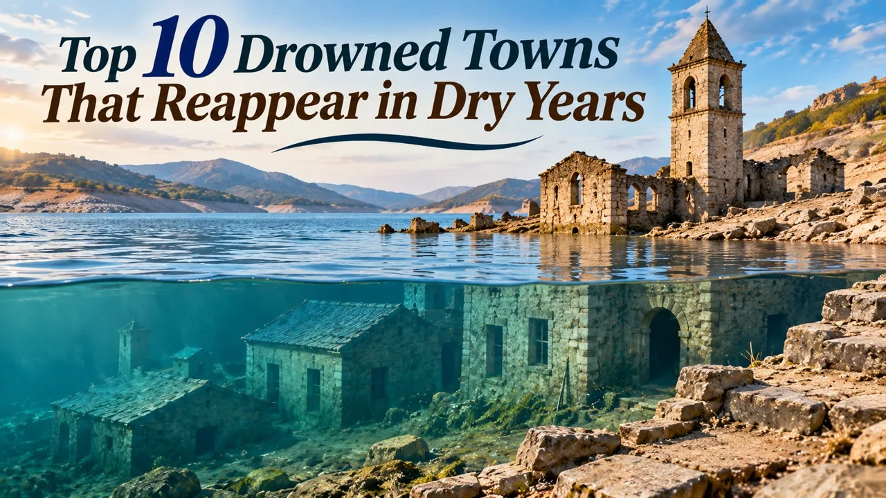
When reservoirs fall in drought or for dam work, drowned towns return to view, from a Catalan church to streets under Lake Mead. Most of the places in this list were flooded on purpose to store water or generate electricity. One was overwhelmed by a nearby salt lake after a dike failed. In every case the reappearance is hydrology, not a mystery: when the waterline drops, stone, timber and street plans that have been sitting underwater come back into the air [1][2][6].
How much of a town you can see depends on the year. At Lake Reschen in Italy a 14th-century church tower stands above the surface even in ordinary seasons, while the rest of old Graun stays down. At Sau Reservoir in Catalonia the church tower is often a landmark in the water, and a severe drought can uncover the nave as well [1][2][9]. A planned drawdown, such as the 2024 emptying of Lac du Chevril at Tignes, can expose ruins that a wet year hides again [8].
This is a curated list of ten well-documented sites, not a ranking by depth, age, or how completely the streets return. The accounts below use official, academic, and established news sources, and they distinguish a town that is only a steeple from a town that has stood dry for years.
Key Facts
Most of these settlements were flooded for reservoirs. Villa Epecuén was flooded by a lake after a dike failed. "Reappear" means the waterline fell enough for ruins to be seen, not that the towns were rebuilt as they were.
Ten Drowned Towns at a Glance
| Rank | Place | Country | Water body | When it was flooded | What reappears |
|---|---|---|---|---|---|
| 1 | Sant Romà de Sau | Spain | Sau Reservoir | Early 1960s | 11th-century church, more complete in drought |
| 2 | Villa Epecuén | Argentina | Laguna Epecuén | 1985 | Salt-crusted town, dry for years |
| 3 | Potosà | Venezuela | Uribante-Caparo reservoir | Mid-1980s | Church and streets in severe drought |
| 4 | St. Thomas | United States | Lake Mead | 1930s | Foundations in the national recreation area |
| 5 | Mediano | Spain | Mediano Reservoir | Late 1960s | Parish church and village remains |
| 6 | Old Adaminaby | Australia | Lake Eucumbene | 1956–1958 | Heritage-listed remnants of the old town |
| 7 | Vilarinho da Furna | Portugal | Vilarinho das Furnas reservoir | 1972 | Village ruins in the dry season |
| 8 | Old Tignes | France | Lac du Chevril | 1952 | Ruins during dam drawdowns |
| 9 | Alt-Graun (Curon Venosta) | Italy | Reschensee | 1950 | Church tower usually visible; more in low water |
| 10 | Mologa | Russia | Rybinsk Reservoir | 1937–1946 | Town remains when the reservoir is low |
1. Sant Romà de Sau
The Church of Sant Romà de Sau stands in Sau Reservoir, in Catalonia, Spain. The 11th-century church and the old village around it were flooded after the reservoir was created in the early 1960s. In a typical year the isolated bell tower is the part most people see, rising from the water as a fixed landmark [1][2].
Drought changes the picture. In 2023 and again in early 2024, water levels in the reservoir fell so far that the nave and other masonry came out of the water. Reuters photographed the re-emerging tower in March 2023. NASA's Earth Observatory later documented the reservoir near empty, and The Guardian reported in March 2024 that the church had become a visible measure of a longer dry spell, with the reservoir reported at around 1 percent of capacity at the low point [1][2][3]. Those figures describe a particular season, not a permanent state. Later rains can hide the church again.
The site is useful because it is both old and closely watched. The architecture can be dated, the reservoir's history is a matter of public record, and satellite images give an independent check on how far the water has dropped [2]. Sant Romà is not a vanished legend. It is a medieval church that spends part of its life underwater and part of it, in dry years, standing in the open air.
2. Villa Epecuén
Villa Epecuén, on the eastern shore of Laguna Epecuén in Buenos Aires Province, Argentina, is the unusual case on this list. It was not flooded to fill a hydroelectric reservoir. It was a 20th-century spa town, developed in the 1920s and reached by train from Buenos Aires, that marketed the salty lake as a health resort. At its height it had a year-round population of about 1,500 and room for thousands of summer visitors [4].
On 6 November 1985 a seiche, set off by a rare weather pattern, broke a nearby dam and then the dike that protected the village. The water rose over a period of days and reached a peak of about 10 metres. The town was not rebuilt. For roughly 25 years it stayed underwater, and when the lake receded the ruins were left coated in white and grey salt [4]. Unlike a reservoir that is refilled every wet season, Epecuén has stood largely dry for years, which is why its street grid, trees, and hotel shells are among the most complete "returned" towns in the world.
Related: Top 10 Haunting Ghost Towns Around the World
One former resident, Pablo Novak, returned in 2009 and lived among the ruins until his death in January 2024, after which the village was described as deserted [4]. His story is part of the record, but the larger fact is hydrological and civic: a resort that was drowned by a failed defence, then left in the open when the water went down, and never put back to its old use.
3. PotosÃ, Venezuela
PotosÃ, in Táchira state, Venezuela, was a settled town with a church at its centre before it was expropriated and flooded in the mid-1980s to create a reservoir in the Uribante-Caparo hydroelectric scheme [5][6]. For years the church and streets sat underwater. Then drought, including a severe El Niño-related dry spell in the mid-2010s, lowered the reservoir far enough for the buildings to come back into view.
National Geographic published before-and-after photographs of the exposed church in 2010. In 2016, BBC Mundo, The Independent, and the Táchira state government documented a still lower waterline, with the church fully uncovered and a stretch of the old settlement, on the order of a kilometre in contemporary reports, visible again [5][6][7]. Official local notices described the ruins as uncovered because of the low level in the Uribante reservoir, not because of a sudden archaeological excavation [7].
As at Sau, the reappearance is reversible. A wetter period can hide Potosà again. What the photographs establish is that a planned reservoir town in the Venezuelan Andes has, more than once, returned as a dry ruin when the climate and the water operators leave the lake short.
4. St. Thomas, Nevada
St. Thomas, Nevada, sat near the meeting of the Muddy River and the Colorado River. Mormon settlers founded it in 1865 under Thomas Smith. The town later served farms and businesses, was briefly a county seat, and was a point on John Wesley Powell's 1869 Colorado River expedition [8]. The settlement's population and ownership changed over the decades, including a departure of many early Latter-day Saint families in 1871 after a boundary shift put the Muddy Mission in Nevada, and a later return of settlers [8].
In the 1930s the rising waters of Lake Mead, formed behind Hoover Dam, covered the town. The federal government purchased the land, residents left, and St. Thomas went under [8]. It did not stay out of sight forever. As Lake Mead fell in the 2000s during a long dry period in the Colorado River basin, foundations, streets, and other remains came back into the air. The site now lies within Lake Mead National Recreation Area, which is the official setting for visits and for the historical record [8].
St. Thomas is one of the clearest American examples of a reservoir town that returned because a famous lake shrank. The ruins are not a reconstruction. They are the original street plan, drying in a national recreation area, visible only for as long as the water stays low.
5. Mediano, Spain
Mediano was a village in the province of Huesca, in Aragón, Spain, before it was flooded by the Mediano Reservoir in the late 1960s. The parish church of Nuestra Señora de la Asunción, and other remains of the old settlement, are the features that come back into view when the water drops [9][10].
Related: Top 10 Great Roman Amphitheatres Still Standing
Spanish newspapers have repeatedly photographed the church and a nearby esconjuradero, a small ritual shelter, standing in the lowered reservoir during drought years, including coverage in 2022 and 2023 [9][10]. A BBC picture gallery of the 2005 European heat also included the exposed church at Mediano, which shows that the reappearance is not a one-season curiosity [11]. When the reservoir is full, those same walls are hidden again.
Mediano is close, in kind, to Sant Romà de Sau: a Spanish village church used as an informal drought gauge. The value of putting both on the same list is geographic as well as architectural. Sau is in Catalonia; Mediano is in the Pyrenean foothills of Aragón. Together they show that "the church in the reservoir" is a pattern in 20th-century Spanish waterworks, not a single photogenic accident.
6. Old Adaminaby
Old Adaminaby, in the Snowy Mountains of New South Wales, Australia, was a working town before it was flooded to create Lake Eucumbene, the largest reservoir in the Snowy Mountains Scheme. The dam and reservoir were built from 1956 to 1958. A new Adaminaby was established nearby, and the old town site, including relics and the drowned landscape, was added to the New South Wales State Heritage Register in 2008 [12].
Because the site is heritage-listed, its identity is not just a local memory. The listing records the former town, the reservoir that covered it, and movable objects associated with the flooding [12]. In dry periods, when Lake Eucumbene falls, remnants of old Adaminaby have been exposed and visited, which is why the drowned town is discussed as something that can be walked as well as remembered.
The Snowy scheme is one of Australia's largest infrastructure projects, and Old Adaminaby is a reminder of what that project cost on the ground: a relocated community, a mapped old town under a reservoir, and a legal heritage file that treats the ruins as part of the national water story, not as a rumour.
7. Vilarinho da Furna
Vilarinho da Furna stood on the banks of the River Homem and the Ribeira do Eido, in the parish of Campo de Gerês, municipality of Terras de Bouro, in northern Portugal. In 1972 the Portuguese state flooded the village as it filled the Vilarinho das Furnas reservoir [13]. The community had a distinctive communal way of managing land and work, which is one reason the lost village is still discussed in Portuguese civic history, not only as a set of wet walls.
Related: Top 10 Largest Temples in the World
Wikipedia and local accounts note that the former villagers still have a legal relationship to the lands, even though the ruins are inundated for much of the year. In the dry season the village emerges and has become a seasonal tourist attraction [13]. That seasonal rhythm is clearer here than at some larger reservoirs: a wet year can hide the streets, a dry year can give them back.
The site sits in the landscape of the Peneda-Gerês country of northern Portugal. What reappears is not a single steeple but the plan of a whole village, which is why Vilarinho is often photographed as a grid of walls rather than as one iconic tower.
8. Old Tignes
The old village of Tignes, in the French Alps, was flooded in 1952 when the Tignes Dam, also called the Chevril Dam, closed the Isère and created Lac du Chevril. The arch dam had been planned for decades, was built between 1948 and 1952 despite local protest, and was the tallest dam in Europe at completion. Water from the reservoir feeds the Brévières and Malgovert hydroelectric stations [14]. A new Tignes grew higher up as a ski resort; the old village did not.
The ruins do not sit in view every summer. They return when the lake is lowered. In 2024, EDF drew down Lac du Chevril for dam maintenance. France 3 and Le Dauphiné Libéré reported that foundations, stone walls, and the old bridge toward Val d'Isère came back into the open. As snowmelt arrived, the reservoir was refilled and the village went under again [15][16].
Tignes is therefore a case of a planned, temporary reappearance, tied to the inspection cycle of a working dam, rather than only to drought. The distinction matters. A drawdown is a scheduled engineering event. It still answers the same physical question: when the water leaves, the town is still there.
9. Alt-Graun on Reschensee
The church tower that stands in Reschensee, or Lake Reschen, in South Tyrol, Italy, is one of the most photographed drowned-village images in Europe, and it is easy to misread. The tower is not a ruin that appears only in drought. It was deliberately left standing when the valley was dammed, and it protrudes from the lake in ordinary years, close to the shore of today's Graun im Vinschgau, also known as Curon Venosta [17][18].
The reservoir was finished in July 1950, after a plan by Montecatini deepened and joined natural lakes and submerged several settlements, including old Graun and part of Reschen. In all, 163 homes and 523 hectares of cultivated land were lost. The 14th-century church tower was spared; the nave was demolished, and the bells were removed on 18 July 1950, a week before that demolition, which is why winter stories about bells still ringing under the ice are folklore, not acoustics [17][18]. When the lake freezes, people can walk out to the tower. When the water is unusually low, more of the old masonry can be seen.
Related: Top 25 Interesting Facts About the Solar System
The honest place for Graun on a list of towns that "reappear" is therefore as a landmark that is usually half-present, and only more fully present when the waterline falls. The village around it is gone from the surface; the tower was never allowed to disappear completely.
10. Mologa
Mologa stood at the confluence of the Mologa and Volga rivers, in what is now Yaroslavl Oblast, Russia. It was an old town, recorded from at least the 12th century, later a trade centre and a staging post on the Volga. In 1935, Soviet authorities ordered the flooding that would create the Rybinsk Reservoir and the Rybinsk hydroelectric plant. Residents were relocated between 1937 and 1941. The last of them left on 14 April 1941, and the former town was completely underwater by 1946 [19]. Earlier reservoir plans had not required Mologa to be sacrificed; a decision to increase the plant's capacity raised the designed water level and put the town under [19].
When the Rybinsk Reservoir is low, remains of Mologa have been exposed again, which is why the drowned city belongs on a list of places that return to view, not only on a list of places that were lost. The history is heavier than a seasonal curiosity. A whole town was moved for a Stalin-era water project, and the site is now a point of memory for descendants as well as a set of wet foundations [19].
This entry stays with the documented sequence: the order, the relocation, the dates, and the fact of submergence under a named reservoir. The ruins, when they appear, are evidence of that sequence, not a ghost story.
Conclusion
A drowned town that reappears is usually a 20th-century water project seen from the other side of the dam. Sau, Mediano, Adaminaby, Vilarinho, Tignes, Graun, PotosÃ, St. Thomas, and Mologa were all put under by reservoirs. Epecuén was put under by a lake that got through a dike, and then was left dry when the water went down and stayed down. The photographs look alike — a church in a bathtub ring, a street ending in mud — but the causes are not identical, and neither is the calendar. Some sites come back every dry season, some only in an extreme year or a planned drawdown, and one Italian tower barely leaves the view at all.
What they share is ordinary and worth stating plainly. The buildings were not erased. They were flooded. When the waterline falls, the map is still there.
- ^ [1] "'It makes me so sad': church re-emerges from reservoir as Spain faces droughts." The Guardian, 2 March 2024. The Guardian: Sant Romà de Sau
- ^ [2] "Sau Reservoir Dries Up." NASA Earth Observatory. NASA Earth Observatory: Sau Reservoir
- ^ [3] "Church tower reemerges from parched reservoir in drought-hit Spain." Reuters, 17 March 2023. Reuters: Sau church tower
- ^ [4] "Villa Epecuén." Wikipedia. Flood of 6 November 1985, later recession of the lake, and later history of the ruins. Wikipedia: Villa Epecuén
- ^ [5] "The town that re-emerged 30 years after it flooded thanks to El Nino." The Independent. The Independent: PotosÃ
- ^ [6] "PotosÃ, el pueblo que emergió en un pantano por la sequÃa en Venezuela." BBC News Mundo, May 2016. BBC Mundo: PotosÃ
- ^ [7] "Ruinas de Potosà al descubierto por bajo nivel de agua en Embalse Uribante." Gobernación del Estado Táchira, 19 April 2016. Táchira government: Potosà ruins
- ^ [8] "St. Thomas, Nevada." Wikipedia. Founding, purchase, submergence under Lake Mead, and reappearance in the 2000s inside Lake Mead National Recreation Area. Wikipedia: St. Thomas, Nevada
- ^ [9] "La sequÃa deja al descubierto la iglesia y el esconjuradero del antiguo pueblo de Mediano." El Diario de Huesca. El Diario de Huesca: Mediano
- ^ [10] "Los pueblos con los embalses secos, nuevo atractivo turÃstico." El Periódico de Aragón, 20 August 2022. El Periódico de Aragón: reservoir villages
- ^ [11] "In pictures: Europe feels heat." BBC News, 2005, including the exposed church at Mediano. BBC: Mediano in 2005
- ^ [12] "Old Adaminaby and Lake Eucumbene." Wikipedia, including the New South Wales State Heritage Register listing of 3 June 2008. Wikipedia: Old Adaminaby and Lake Eucumbene
- ^ [13] "Vilarinho da Furna." Wikipedia. Flooding in 1972 and seasonal reappearance of the ruins. Wikipedia: Vilarinho da Furna
- ^ [14] "Tignes Dam." Wikipedia. Construction, 1952 completion, and Lac du Chevril. Wikipedia: Tignes Dam
- ^ [15] "Ils ne voulaient pas partir de chez eux : vidé, le lac de Tignes fait ressurgir un village englouti." France 3 Auvergne-Rhône-Alpes, 2024. France 3: Old Tignes exposed
- ^ [16] "Vidange du barrage de Tignes : des images toujours impressionnantes." Le Dauphiné Libéré, 26 March 2024. Le Dauphiné: Tignes drawdown
- ^ [17] "Reschensee." Wikipedia. Reservoir history, 1950 completion, and the church tower, including the removal of the bells. Wikipedia: Reschensee
- ^ [18] "Graun im Vinschgau." Wikipedia. Rebuilding of Graun on the new shore and the spared 14th-century tower. Wikipedia: Graun im Vinschgau
- ^ [19] "Mologa." Wikipedia. Town history, 1935 flooding order, relocation through 14 April 1941, and submergence by 1946. Wikipedia: Mologa





















Discussion
Log in with