









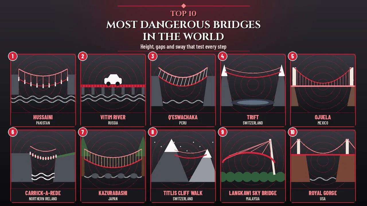
The most dangerous bridges in the world, from Pakistan's Hussaini hanging bridge to Peru's grass-rope Q'eswachaka, test nerves with height, gaps and sway. Some were built by villagers who simply needed to get across a river, while others were designed as thrill attractions on cliffs and mountain summits. What they share is exposure: very little stands between the person crossing and a long drop.
Danger on a bridge is rarely about a structure that is likely to fail. It usually comes from the conditions around it, such as wind, missing handrails, rotting planks, ice, fast water or simply the height. This list ranks ten famous crossings by how exposed and unforgiving they feel, and it explains how each one is managed today so that readers can tell the genuinely risky from the merely terrifying.
Every figure below was checked against official tourism bodies, operators, heritage registers and reputable news reports, and the details are current as of October 2026. Anyone planning a visit should follow local rules and closures, because several of these bridges shut without notice in bad weather.
How This List Was Ranked
The bridges were compared on five factors that together decide how dangerous a crossing feels and how much can go wrong. A rope bridge 14 metres above a river can be more unnerving than a steel bridge hundreds of metres up if it has open gaps, moves with every step and sits in a remote valley. Bridges that are poorly maintained or officially closed but still used rank highest.
| Factor | What it means | Why it matters |
|---|---|---|
| Height and drop | Distance from the deck to the water, rocks or valley floor | A fall from any of these heights can be fatal |
| Deck and handrails | Gaps between planks, deck width, and whether rails are high and continuous | Open gaps and low rails are the most common causes of slips |
| Movement | How much the bridge sways or bounces in wind and under foot | Sway makes people grip, freeze or lose balance |
| Maintenance and status | Whether an owner inspects and repairs it, or whether it is abandoned | Unmaintained bridges can lose planks or supports |
| Setting and access | Altitude, weather, cold, fast rivers and distance from rescue services | Remote bridges leave little room for error |
The Most Dangerous Bridges at a Glance
| Rank | Bridge | Country | Length | Height above water or ground | Main hazard |
|---|---|---|---|---|---|
| 1 | Hussaini Suspension Bridge | Pakistan | About 194 m | Low over a fast glacial river | Wide gaps between planks, strong wind and icy water |
| 2 | Vitim River Bridge | Russia | About 570 m | Low over a broad Siberian river | No railings, rotting sleepers and a deck barely wider than a car |
| 3 | Q'eswachaka Bridge | Peru | About 28 m | About 15 m | Woven entirely from grass and rebuilt every year |
| 4 | Trift Bridge | Switzerland | About 170 m | About 100 m | High alpine sway above a glacial lake |
| 5 | Ojuela Bridge | Mexico | About 314 m | Roughly 90 m | A long, flexing wooden deck over a desert canyon |
| 6 | Carrick-a-Rede Rope Bridge | United Kingdom | 20 m | 30 m | Coastal wind over rocks and sea |
| 7 | Iya-no-Kazurabashi | Japan | 45 m | 14 m | Vine ropes and open slats over a rocky river |
| 8 | Titlis Cliff Walk | Switzerland | About 100 m | About 500 m chasm | Altitude near 3,000 m, cold and only 1 m of width |
| 9 | Langkawi Sky Bridge | Malaysia | 125 m | Deck 660 m above sea level | A curved deck hanging over a rainforest summit |
| 10 | Royal Gorge Bridge | United States | 384 m | 291 m | One of the highest bridge decks in the world |
1. Hussaini Suspension Bridge
The Hussaini Suspension Bridge in northern Pakistan is often described as the scariest bridge on Earth, and one look at its deck explains why. Wooden planks are spaced so far apart that walkers must step from board to board while the whole structure rocks above the Hunza River. It links the villages of Hussaini and Zarabad in Upper Hunza, deep in the Karakoram mountains.
| Attribute | Details |
|---|---|
| Location | Gojal area, Hunza District, Gilgit-Baltistan, Pakistan |
| Crosses | Hunza River, between Hussaini and Zarabad villages |
| Length | About 194 m (635 ft) |
| Structure | Wooden planks hung from six main ropes |
| Main hazard | Gaps between planks, wind sway and cold, fast water |
Origins and History
A crossing has existed at this spot since around 1968, built so that villagers could reach fields and neighbours on the far bank. The Hunza valley is shaped by landslides and floods, and the bridge has had to be rebuilt. The latest major reconstruction followed the Attabad landslide of January 2010, which blocked the Hunza River, created Attabad Lake and badly disrupted life in the upper valley.
The bridge sits a short walk from the Karakoram Highway, between the villages of Gulmit and Passu. That location turned a local footpath into one of the most photographed stops on the road to the Chinese border.
Why It Feels So Dangerous
- The planks are deliberately spaced with large gaps, which lets wind pass through instead of catching the deck like a sail.
- The deck swings and twists with every step, especially when several people cross at once.
- The Hunza River below is cold, grey with glacial silt and very fast.
- Gusts funnel through the valley with little warning.
Safety Today
Local operators and officials advise visitors to wear life jackets and to cross slowly with a firm grip on the side ropes. Tragedy has struck here: in July 2022 a student visiting from Sindh fell from the bridge and drowned, and the crossing was sealed for several days while the case was investigated.
Interesting Facts
- Condé Nast Traveler included the Hussaini bridge in a 2013 round-up of the world's most dangerous bridges.
- The jagged Passu Cones, a famous mountain skyline, rise just north of the bridge area.
- Life jackets are among the precautions visitors are asked to take, a rare rule for a footbridge.
2. Vitim River Bridge
The Vitim River Bridge in Siberia was never meant to carry cars, yet for decades drivers have edged across it on rotting wooden sleepers with no railings at all. Russians nicknamed it the "bridge of death", and it is probably the most hazardous crossing on this list that people still use. It spans the Vitim River near the settlement of Kuanda, on the border between Zabaykalsky Krai and Buryatia.
| Attribute | Details |
|---|---|
| Location | Near Kuanda, Kalarsky district, Zabaykalsky Krai, Russia |
| Also known as | Kuandinsky Bridge |
| Length | About 570 m |
| Built | Early 1980s (usually dated 1982) as a temporary railway crossing |
| Status | Traffic officially banned since 2016; supports damaged by ice in 2018 |
Origins and History
The bridge was put up in the early 1980s as a temporary crossing for trains while workers built the permanent bridge of the Baikal-Amur Mainline railway, known as BAM. Once the permanent bridge opened nearby, the temporary one was abandoned, and reports say an attempt to burn it failed. Local residents then turned it into a road crossing by laying wooden sleepers between the two narrow steel platforms that remained.
Because it was never formally put into service as a road, nobody officially maintained it. Villagers patched the deck themselves, and the timber gradually rotted in the harsh Siberian climate.
Why It Feels So Dangerous
- There are no railings, kerbs or barriers of any kind.
- The usable deck is only slightly wider than a car's wheel track, so a small steering error can put a wheel over the edge.
- Sleepers are loose, broken or missing in places, and the surface turns slick with rain, snow and ice.
- Strong spring currents and ice floes batter the supports every year.
Significance and Current Status
In 2016 the French newspaper Ouest-France put the bridge in its list of the ten most dangerous roads in the world, and in the same year a court decision banned vehicles and pedestrians from using it. In 2018 ice destroyed two of its supports, making it unusable for traffic, although locals were reported crossing it again afterwards. In 2024 regional officials said Russian Railways planned to restore the crossing to haul materials for the Kodar Tunnel on the BAM, a project due by 2030.
Interesting Facts
- Online videos of drivers crossing the bridge have drawn millions of views.
- The bridge is about half a kilometre long, so a crossing can take many minutes at walking pace.
- Its two narrow steel platforms are each only about half a metre wide.
3. Q'eswachaka Bridge
The Q'eswachaka Bridge in Peru is the last Inca rope bridge still in use, and it is woven entirely from grass. Every June, local communities cut down the old bridge and build a completely new one by hand over three days. It hangs over a gorge of the Apurímac River in the southern Andes, in the Quehue district of Canas province, Cusco region.
| Attribute | Details |
|---|---|
| Location | Quehue district, Canas province, Cusco region, Peru |
| Crosses | Apurímac River gorge |
| Size | About 28 m long and 1.2 m wide, roughly 15 m above the water |
| Material | Ropes twisted from ichu, a tough Andean grass |
| Recognition | Cultural Heritage of the Nation (2009); UNESCO Intangible Cultural Heritage (2013) |
Origins and History
The bridge belongs to the Qhapaq Ñan, the vast road network of the Inca Empire, and a crossing has existed here for around 500 years. Grass bridges once spanned many Andean gorges, but most disappeared as steel bridges and highways arrived. By about 1970 the old bridge was hanging unused next to a modern road bridge, and in 1973 the four communities of Quehue revived the annual rebuilding.
Those communities are Huinchiri, Chaupibanda, Choccayhua and Ccollana Quehue. For them the bridge is a sacred bond with nature, their ancestors and Pachamama, the Earth Mother, rather than just a way across the river.
How the Bridge Is Rebuilt
- Each family twists grass into thin cords about 70 m long and brings them to the site.
- Master bridge builders guide the braiding of these cords into six great ropes.
- The great ropes are tied to ancient stone anchors on both banks.
- The old bridge is cut loose and dropped into the river below.
- Builders weave the new deck and railings from opposite ends until they meet in the middle.
Why It Feels So Dangerous
A bridge made of grass naturally sags, sways and stretches under weight. Its deck is narrow, its railings are flexible ropes, and the river rushes through a steep rocky gorge below. The bridge depends on being renewed every year, and that weakness showed during the COVID-19 pandemic.
Significance and Recent Events
When the 2020 renewal could not go ahead, the unmaintained bridge collapsed in March 2021, and the communities rebuilt it soon afterwards. It fell again on 17 May 2025 after what officials described as an act of vandalism, and it was restored once more. These events show both the fragility of a grass bridge and the strength of the tradition that keeps it alive.
Interesting Facts
- About 1,000 people gather at the gorge for the renewal in the second week of June.
- A ritual specialist makes offerings to the earth and the mountain spirits before work begins.
- A modern steel bridge stands nearby, so the grass bridge survives by choice, not necessity.
4. Trift Bridge
The Trift Bridge in the Swiss Alps is a slender pedestrian suspension bridge strung about 100 metres above a turquoise glacial lake. It exists because climate change melted the ice that hikers once walked across. The bridge sits above the Triftsee near Gadmen in the Bernese Oberland and is reached only by cable car and a steep hike.
| Attribute | Details |
|---|---|
| Location | Above the Triftsee, near Gadmen, canton of Bern, Switzerland |
| Length | About 170 m |
| Height | About 100 m above the lake |
| Built | First bridge 2004; current bridge opened 12 June 2009 |
| Access | Cable car, then roughly 1.5 hours of uphill hiking |
Origins and History
For generations, climbers reached the Trift Hut by walking over the Trift Glacier. As the glacier retreated quickly in the early 2000s, a lake formed in its place and the old route became unsafe. In 2004 a simple suspension bridge, modelled on footbridges used in Nepal, was strung across the gap to restore access.
That first bridge was basic, and it moved a great deal in the wind. A sturdier replacement opened on 12 June 2009, after just six weeks of construction, and parts of the original were later reused for the Salbitbrücke, another high pedestrian bridge in the canton of Uri.
Key Features
- The 2009 bridge added side planks and higher, reinforced handrails.
- Wind bracing cables reduce the swing that made the first bridge infamous.
- The deck is narrow and the meltwater lake glows far below.
- Mountain weather can change from sunshine to fog and storms within an hour.
Significance
The Trift Bridge has become a symbol of how quickly Alpine glaciers are shrinking. Hikers come for the thrill, but the view below is also a lesson in climate change, since the lake under the deck was ice within living memory. It remains one of the longest and highest pedestrian suspension bridges in the Alps.
Interesting Facts
- The bridge is usually reachable only in the snow-free summer and early autumn season.
- There is no road to the bridge, so the last stretch is always on foot.
- The Trift Hut beyond the bridge is a base for high mountain tours.
5. Ojuela Bridge
The Ojuela Bridge in northern Mexico is a long wooden suspension bridge that once carried mine cars across a deep desert canyon and now carries only brave walkers. Its deck flexes and creaks underfoot, and the canyon floor lies far below. It stands at the old Ojuela mining settlement in the Mapimí municipality of Durango state.
| Attribute | Details |
|---|---|
| Location | Ojuela, Mapimí municipality, Durango, Mexico |
| Length | About 314 m, with a main span of about 271.5 m |
| Height | A 1908 report put it about 300 ft (roughly 90 m) above the canyon floor |
| Built | Late 1890s, most reliably dated to 1899 (a plaque cites 1892) |
| Original use | Railway for carrying ore from the Ojuela mine |
Origins and History
Spanish miners were digging silver at Ojuela from the late 16th century, and the Mapimí mining district was founded in 1598. By the 1890s the mine had become a major industrial operation, but deep ravines made it hard to move ore. A suspension bridge was built to link the workings, with steel cables supplied by John A. Roebling's Sons Company of Trenton, New Jersey, the firm associated with the Brooklyn Bridge.
The exact construction date is disputed. Tourist descriptions and a plaque cite 1892, while a 1908 engineering report and the municipal history of Mapimí place completion in 1899. German-born engineer Wilhelm Hildenbrand is usually named as its designer.
Why It Feels So Dangerous
- The deck is made of wooden planks that move and bounce under each step.
- The bridge is very long, so walkers spend several minutes suspended over the canyon.
- Desert heat, strong sun and gusting wind make the crossing tiring.
- The surrounding ghost town has steep, rough paths and old mine openings.
Significance
When it was built, the Ojuela Bridge was among the longest suspension bridges in existence. It is now a rare surviving example of an industrial mining bridge from that era, and it draws visitors to the abandoned town and mine tunnels around it.
Interesting Facts
- The original deck was much wider than today's walkway because it carried a track for mine cars.
- A 1908 account described the bridge as about 1,100 feet long.
- Ojuela was a company settlement whose fortunes rose and fell with the mine.
6. Carrick-a-Rede Rope Bridge
The Carrick-a-Rede Rope Bridge in Northern Ireland is short, but it sways 30 metres above rocks and sea on an exposed stretch of the Atlantic coast. It links the mainland near Ballintoy, County Antrim, to the tiny island of Carrickarede. Its name comes from the Irish Carraig a' Ráid, meaning rock of the casting.
| Attribute | Details |
|---|---|
| Location | Near Ballintoy, County Antrim, Northern Ireland, United Kingdom |
| Length | 20 m (66 ft) |
| Height | 30 m (98 ft) above the rocks |
| Current bridge | Wire rope and Douglas fir, installed in 2008 |
| Owner | National Trust |
Origins and History
Salmon fishermen are thought to have built bridges to the island for more than 350 years, so they could reach nets set where fish passed on their way to the River Bann and River Bush. In the 1970s the bridge still had only one handrail and wide gaps between its slats. New bridges followed in 2000 and 2004, and the present structure was raised in early 2008 at a cost of more than 16,000 pounds.
Salmon numbers fell sharply over the decades. Around 300 fish a day were caught in the 1960s, but only about 250 were caught in the whole 2002 season, and the bridge is no longer used for fishing.
Why It Feels So Dangerous
- Atlantic winds hit the cliffs and make the bridge swing.
- The drop below is onto rocks and churning sea, not open water.
- The island's grassy top is small and exposed, with steep drops to the sea on every side.
Safety Today
The National Trust owns and maintains the bridge, and it can close at short notice in high winds. It has been open all year since 2009, subject to weather. Some visitors who cross find they cannot face the walk back, and over the years a number have had to be taken off the island by boat.
Interesting Facts
- The site welcomed 485,736 visitors in 2018.
- Carrickarede island is the best example of a volcanic plug in Northern Ireland, formed about 60 million years ago.
- On clear days Rathlin Island and the coast of Scotland are visible from the cliffs.
- In May 2017 vandals damaged its structural ropes overnight, and engineers repaired them the next day.
7. Iya-no-Kazurabashi
Iya-no-Kazurabashi in Japan is a suspension bridge woven from mountain vines, and through its open slats walkers can see the Iya River 14 metres below. It is the largest of the vine bridges that survive in the remote Iya Valley of Tokushima Prefecture, on the island of Shikoku. Visitors cross it slowly, gripping the vine rails while the deck rocks gently.
| Attribute | Details |
|---|---|
| Location | Nishi-Iya, Miyoshi City, Tokushima Prefecture, Japan |
| Size | 45 m long, 2 m wide, about 14 m above the Iya River |
| Material | Several tonnes of hardy kiwi vines (Actinidia arguta) |
| Maintenance | Completely rebuilt every three years |
| Status | Important Tangible Folk Cultural Property of Japan |
Origins and History
Nobody knows exactly when the first vine bridges appeared in Iya. One legend says they were built by members of the defeated Taira clan, also called the Heike, who fled into the valley after the Genpei War of 1180 to 1185. Vine bridges could be cut down quickly if enemies came. Another story credits the Buddhist monk Kobo Daishi with building them to help villagers.
At one time 13 vine bridges spanned the valley. Only three remain: the main Iya-no-Kazurabashi in Nishi-Iya and the Oku-Iya double vine bridges near Mount Tsurugi in the eastern valley.
Key Features
- Wide gaps between the wooden slats show the rushing river below.
- The vines are anchored to tall trees on both banks.
- Steel cables are hidden inside the vines for safety.
- Crossing is one way only, to keep traffic flowing.
Significance
The bridge is counted among Japan's three unusual bridges and is one of the country's most loved folk heritage sites. It shows how remote mountain communities solved transport problems with local materials long before modern engineering arrived.
Interesting Facts
- The bridge is lit up in the evening, although crossing is not allowed while it is illuminated.
- Vines for rebuilding are gathered in the cold of winter.
- A waterfall linked to the Heike legend lies a short walk from the far end.
8. Titlis Cliff Walk
The Titlis Cliff Walk in central Switzerland is a suspension bridge only one metre wide, strung along a cliff at about 3,000 metres above sea level with a chasm of around 500 metres below. When it opened in 2012 it was believed to be the highest-elevation suspension bridge in Europe. It hangs near the summit of Mount Titlis above the resort of Engelberg.
| Attribute | Details |
|---|---|
| Location | Mount Titlis, above Engelberg, Switzerland |
| Length and width | About 100 m long and 1 m wide |
| Elevation | About 3,041 m above sea level at the viewing platform end |
| Drop below | A chasm of around 500 m |
| Opened | 7 December 2012 (public opening the next day) |
Origins and History
The Cliff Walk was built to mark 100 years since the Engelberg to Gerschnialp funicular opened in January 1913. Construction took about five months, with work done whenever the weather allowed. Most materials came up by cable car, and larger sections were delivered by helicopter.
The official opening on 7 December 2012 took place in a snowstorm, so the guests from 15 countries could barely see a few metres ahead. Media soon called it the world's scariest bridge.
Key Features
- Crossing takes about 150 steps from rock face to rock face.
- The bridge was designed to resist winds of more than 190 km/h.
- It can carry around 450 tonnes of snow.
- At its far end it connects to the Ice Flyer chairlift above the glacier.
Why It Feels So Dangerous
Thin air, cold and the sheer drop combine to make even fit visitors feel light-headed. The resort says it is impossible to fall from the bridge, but the narrow deck and open sides make that hard to believe in the moment. Weather at this altitude can close the summit with little warning.
Interesting Facts
- It broke the European height record previously held by the Salbit Bridge, also in Switzerland.
- About 500 people crossed it in its first two weeks.
- Visitors reach it from the summit station through an ice grotto.
9. Langkawi Sky Bridge
The Langkawi Sky Bridge in Malaysia is a curved pedestrian bridge whose deck hangs 660 metres above sea level at the top of a rainforest-covered peak. It is held up by cables from a single pylon, so from a distance it seems to float. It sits on Gunung Mat Cincang on Langkawi, the main island of the Langkawi archipelago in Kedah state.
| Attribute | Details |
|---|---|
| Location | Gunung Mat Cincang, Pulau Langkawi, Kedah, Malaysia |
| Length and width | 125 m long, about 1.8 m wide |
| Elevation | Deck 660 m above sea level |
| Structure | Curved cable-stayed walkway hung from one 82 m pylon |
| Completed | 2005 |
Origins and History
The bridge was designed by Peter Wyss as a curved walkway, so that the view shifts as visitors move along it. It is made of five 25 metre sections: straight at each end and curved in the middle, with a triangular viewing platform at both ends. The deck is formed of steel and concrete panels on an inverted triangular truss.
The bridge closed for maintenance and upgrades in July 2012. Its reopening was postponed several times before it partially reopened in February 2015, and it is now fully accessible.
Key Features
- Visitors arrive by the Langkawi Cable Car, then ride the SkyGlide inclined lift down to the bridge.
- A steeper and less secure mountain track is the cheaper alternative to the SkyGlide.
- Steel railings and wire mesh line both sides of the deck.
- The bridge can hold a maximum of 250 people at once.
Why It Feels So Dangerous
The bridge is hung from just one pylon, so the deck seems to hang in mid-air above the forest canopy. Tropical storms, clouds and strong winds sweep across the summit, and the bridge can close in bad weather. On a clear day the drop to the jungle and the Andaman Sea views make the curved deck feel very exposed.
Interesting Facts
- The final scene of the 2006 Indian film Don was filmed on the bridge.
- The Tamil film Billa (2007) was also shot there.
- The pylon foundation sits 605 m above sea level, and the top of the pylon reaches 687 m.
10. Royal Gorge Bridge
The Royal Gorge Bridge in Colorado carries visitors 955 feet (291 metres) above the Arkansas River, and for more than 70 years it was the highest bridge in the world. Its wooden deck sits so high that the river and railway at the bottom of the gorge look like thin lines. It stands within Royal Gorge Bridge and Park near Cañon City.
| Attribute | Details |
|---|---|
| Location | Royal Gorge Bridge and Park, near Cañon City, Colorado, United States |
| Height | 955 ft (291 m) above the Arkansas River |
| Size | Main span 880 ft (268 m); total length 1,260 ft (384 m); 18 ft (5.5 m) wide |
| Deck | 1,292 wooden planks on a steel structure |
| Built | June to November 1929, opened 8 December 1929 |
Origins and History
The bridge was built in about six months in 1929 at a cost of 350,000 dollars, which was 100,000 dollars over budget. It was financed by Lon P. Piper of San Antonio, Texas, and designed under chief engineer George E. Cole, with no deaths or serious injuries during construction. It was built purely as a tourist attraction rather than as a through route.
It held the world record for the highest bridge from 1929 until 2001, when it was passed by the Liuguanghe Bridge in China. It remained the world's highest suspension bridge until 2003 and is still the highest bridge in the United States.
Key Features
- Passenger cars are no longer allowed to cross the bridge.
- The Royal Gorge Route Railroad runs along the floor of the gorge below.
- A gondola, zip line and Skycoaster now operate around the bridge.
Why It Feels So Dangerous
Few people can look over the railing at a nearly 300 metre drop without a jolt of fear. Wind gusts move along the canyon, and the sheer walls make the height easy to grasp. The bridge itself is carefully maintained, so the danger is mostly in the mind.
Interesting Facts
- A wildfire in June 2013 destroyed most of the park's buildings, but the bridge suffered only slight damage to its deck.
- The park held a grand reopening in May 2015 with new gondolas.
- In the early 1980s the bridge received new cable anchors, suspension rods and paint.
Honourable Mentions
Several other famous bridges are often named among the scariest in the world. Most are well engineered and closely managed, but their height, length or appearance still gives visitors a fright.
| Bridge | Country | Key numbers | Why it scares people |
|---|---|---|---|
| Capilano Suspension Bridge | Canada | 140 m long, 70 m above the Capilano River | A swaying deck high above a forested canyon in North Vancouver |
| Zhangjiajie Grand Canyon Glass Bridge | China | 430 m long, about 300 m above the ground | A transparent glass floor; it closed 13 days after opening in 2016 because of huge crowds |
| Charles Kuonen Suspension Bridge | Switzerland | 494 m long, 65 cm wide, up to 85 m high | A see-through mesh deck barely wider than a walker's shoulders |
| Sky Bridge 721 | Czech Republic | 721 m long, up to 95 m above the ground | One of the longest pedestrian suspension bridges in the world |
| Storseisundet Bridge | Norway | 260 m long, 23 m above the sea | Its curve makes the road appear to end in mid-air, and storms send waves over the Atlantic Road |
| Eshima Ohashi Bridge | Japan | 1.7 km long, rising to 44.7 m | Telephoto photos make it look like a cliff, though its gradient is only 6.1 percent |
| Deception Pass Bridge | United States | 453 m long, about 55 m above the water | Narrow sidewalks above tidal currents that can run at about 9 knots |
Scary Versus Truly Risky
Not every frightening bridge is equally dangerous. Engineers design tourist bridges such as the Royal Gorge Bridge, Langkawi Sky Bridge and Titlis Cliff Walk with large safety margins, inspections and weather closures. The real risks are higher where a bridge is unmaintained, has open sides, or sits far from help.
| Type of bridge | Examples | Main risk | How it is managed |
|---|---|---|---|
| Abandoned or unofficial crossings | Vitim River Bridge | Structural decay, no rails, no inspections | Officially closed, but still used by some locals |
| Traditional village bridges | Hussaini, Q'eswachaka | Gaps, sway, natural materials, fast rivers | Community repairs, annual renewal and life jackets |
| Historic heritage bridges | Ojuela, Iya-no-Kazurabashi, Carrick-a-Rede | Aging or natural materials and exposure | Regular rebuilding, hidden steel cables and weather closures |
| Modern thrill attractions | Trift, Titlis Cliff Walk, Langkawi Sky Bridge, Royal Gorge | Altitude, wind and fear of heights | Engineered handrails, wind bracing and weather closures |
Tips for Crossing a Scary Bridge Safely
Visiting one of these bridges can be a highlight of a trip, as long as visitors respect the conditions. These simple habits reduce the risk of slips, panic and accidents.
- Check opening times, weather alerts and closures before you travel.
- Wear shoes with good grip, and avoid crossing in strong wind, rain, snow or ice.
- Keep both hands free and hold the handrails or side ropes the whole way.
- Never climb over railings, sit on the edge or lean out for photos.
- Follow capacity limits and do not bounce or swing the deck.
- Wear a life jacket where one is offered or required, as at Hussaini.
- If fear sets in, stop, breathe slowly and look ahead rather than down.
- Never use an officially closed bridge, however many others do.
Comparison: How High Are They?
| Bridge | Drop below the deck | Material of the walking surface | Year of current structure |
|---|---|---|---|
| Titlis Cliff Walk | About 500 m chasm | Narrow steel suspension walkway | 2012 |
| Royal Gorge Bridge | 291 m | Wooden planks on steel | 1929 |
| Trift Bridge | About 100 m | Narrow suspended deck with side planks | 2009 |
| Ojuela Bridge | Roughly 90 m | Wooden planks on steel cables | Late 1890s |
| Carrick-a-Rede Rope Bridge | 30 m | Douglas fir planks on wire rope | 2008 |
| Q'eswachaka Bridge | About 15 m | Woven grass and branches | Rebuilt every June |
| Iya-no-Kazurabashi | 14 m | Wooden slats and vines | Rebuilt every three years |
| Langkawi Sky Bridge | Deck 660 m above sea level on a summit | Steel and concrete panels | 2005, upgraded 2012 to 2015 |
| Hussaini Suspension Bridge | Low over the river | Spaced wooden planks on ropes | Rebuilt after 2010 |
| Vitim River Bridge | Low over the river | Loose wooden sleepers on steel | Early 1980s |
Frequently Asked Questions
What is the most dangerous bridge in the world?
There is no official ranking, but the Hussaini Suspension Bridge in Pakistan and the Vitim River Bridge in Russia are most often named. Hussaini has wide gaps between its planks and sways over a fast glacial river, while the Vitim bridge has no railings and has been officially closed since 2016 because of its poor condition.
Is the Hussaini bridge safe to cross?
Many tourists cross the Hussaini bridge, but it demands care. Visitors are advised to wear a life jacket, cross slowly, hold the side ropes and avoid windy weather. A visitor drowned after falling from it in July 2022, so anyone who is unsteady, unwell or afraid of heights should enjoy the view from the bank instead.
Why is the Q'eswachaka bridge rebuilt every year?
The Q'eswachaka bridge is made of ichu grass, which weakens with rain, sun and use. Every June, four Quechua communities cut down the old bridge and weave a new one in about three days, following Inca techniques. UNESCO added this renewal tradition to its Intangible Cultural Heritage list in 2013, and it keeps the bridge strong enough to use.
What is the highest bridge on this list?
The Royal Gorge Bridge in Colorado has the greatest height between its deck and the river, at 955 feet or 291 metres. The Titlis Cliff Walk sits higher above sea level, at about 3,000 metres, with a chasm of about 500 metres below. The Langkawi Sky Bridge deck is 660 metres above sea level on a mountain summit.
Can you still drive across the Vitim River Bridge?
Officially, no. A court decision banned vehicles and pedestrians from the bridge in 2016, and ice destroyed two of its supports in 2018. Reports suggest some locals have still crossed it since then, which is extremely dangerous. In 2024 officials said Russian Railways planned to restore the crossing for work on the Baikal-Amur Mainline.
Which famous scary bridge is safest for nervous visitors?
Modern, staffed attractions such as the Capilano Suspension Bridge, the Langkawi Sky Bridge and the Titlis Cliff Walk are the best choice for nervous visitors. They are professionally engineered and managed, with railings, inspections and weather closures. The thrill comes from height and movement, while the engineering keeps the actual risk low.
Conclusion
The most dangerous bridges in the world range from a rotting railway crossing in Siberia to a grass bridge that Andean communities rebuild by hand every year. Hussaini, Vitim and Q'eswachaka feel most perilous because they combine gaps, sway, fragile materials and fast rivers, while Trift, Titlis, Langkawi and Royal Gorge thrill visitors with sheer height and engineered exposure. In between, Ojuela, Carrick-a-Rede and Iya-no-Kazurabashi show how working bridges built for mines, fishermen and villagers became heritage landmarks.
Each of these crossings is safest when visitors respect the weather, the rules and their own limits. For more places that test courage, read our guides to the most dangerous tourist destinations in the world and the most dangerous mountains in the world, see how engineers push limits in the longest suspension bridge spans in the world, or browse more lists in Top 10 Facts.
- Chita.ru (26 August 2024), RBC, Infpol and The Drive reports on the Vitim (Kuandinsky) bridge, its 2016 ban, 2018 ice damage and restoration plans
- UNESCO Intangible Cultural Heritage, Knowledge, skills and rituals related to the annual renewal of the Q'eswachaka bridge (inscribed 2013, decision 8.COM 8.22), and the UNESCO Courier feature on the renewal
- PBS SoCal, Peru's Q'eswachaka rope bridge, on the 1973 revival and the rebuilding process
- Tokushima Prefecture, Miyoshi City tourism, Nishi-Awa tourism and the Japan National Tourism Organization pages on Iya-no-Kazurabashi
- Claude T. Rice, The Engineering and Mining Journal (1908), and the municipal history of Mapimí, as summarised in encyclopaedic coverage of the Ojuela Bridge
- National Trust information on the Carrick-a-Rede Rope Bridge
- Encyclopaedic reference entries on the Hussaini Suspension Bridge, Trift Bridge, Carrick-a-Rede Rope Bridge, Titlis Cliff Walk, Langkawi Sky Bridge, Royal Gorge Bridge and the honourable mentions, used to cross-check dimensions and dates
- Reference topic only: 10mosttoday.com list of the most dangerous bridges in the world (2020)














Log in with