






 By
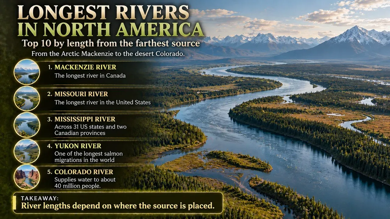
The longest rivers in North America are led by Canada's Mackenzie River. With its tributaries, the Mackenzie system runs 4,241 kilometres from the mountains of British Columbia to the Arctic Ocean.[1] The Missouri and the Mississippi come next, each about 3,766 kilometres long. When the Missouri is combined with the lower Mississippi, the two form the world's fourth-longest river system.[2][3] Between them, these great rivers drain forests, prairies, deserts and tundra across Canada, the United States and Mexico. They carried Indigenous peoples, fur traders, gold seekers and steamboats, and they still supply water, power and shipping routes to tens of millions of people.[2][9]
This Finepedia list, updated in October 2026, ranks the top 10 longest rivers in North America. It explains how each river is measured, where each one flows, and what makes it important.
How This List Is Ranked
A river's length depends on where its source is placed. Some rivers on this list are measured as a single named river. Others, such as the Mackenzie, the St. Lawrence, the Nelson and the Ohio, are measured as a chain of linked rivers and lakes from the farthest headwater to the mouth.[1][5][7][10] Where a figure covers a whole system, the length of the main named river is also given. The Missouri and Mississippi are ranked separately rather than as one combined system.
Key Facts
The table below sums up the ten rivers on this list in ranked order.
The 10 Rivers at a Glance
| Rank | River | Length | Countries | Mouth |
|---|---|---|---|---|
| 1 | Mackenzie (with Slave, Peace and Finlay) | 4,241 km | Canada | Beaufort Sea, Arctic Ocean |
| 2 | Missouri | 3,767 km | United States | Mississippi River |
| 3 | Mississippi | 3,766 km | United States | Gulf of Mexico |
| 4 | Yukon | 3,190 km | Canada, United States | Bering Sea |
| 5 | St. Lawrence (from farthest headwater) | 3,058 km | Canada, United States | Gulf of St. Lawrence |
| 6 | Rio Grande | 3,051 km | United States, Mexico | Gulf of Mexico |
| 7 | Nelson (with Saskatchewan and Bow) | 2,575 km | Canada | Hudson Bay |
| 8 | Arkansas | 2,364 km | United States | Mississippi River |
| 9 | Colorado | 2,330 km | United States, Mexico | Gulf of California |
| 10 | Ohio (with Allegheny) | 2,110 km | United States | Mississippi River |
Sources: lengths from references [1] to [10].
1. Mackenzie River, Canada (4,241 km)
The Mackenzie River flows through the boreal forest and tundra of northern Canada. Together with the Slave, Peace and Finlay rivers, it forms the longest river system in Canada.[1] Its main stem is 1,738 kilometres long and flows north-northwest from Great Slave Lake to the Arctic Ocean, where it forms a large delta. Including its tributaries, it is 4,241 kilometres long.[1] The main river lies entirely within the Northwest Territories, but its tributaries reach into five other Canadian provinces and territories. Its ultimate source is Thutade Lake in northern British Columbia.[1]
Why It Matters
The Mackenzie's watershed drains about 20 percent of Canada. It is the largest river flowing into the Arctic from North America and has the second-largest drainage basin of any North American river, after the Mississippi.[1] On a world scale, it is the 13th-longest river system and has the 12th-largest drainage basin on Earth.[1]
Interesting Facts
- Names: In Slavey it is called Deh-Cho, meaning "big river". In Inuvialuktun it is Kuukpak, meaning "great river". [1]
- Explorer: The Scottish explorer Alexander Mackenzie followed the river hoping it would lead to the Pacific Ocean. Instead he reached its mouth on the Arctic Ocean on 14 July 1789. [1]
- Ice road: The river usually freezes by late October or November. In winter, its frozen channel, especially in the delta, serves as an ice road strong enough to carry large trucks. [1]
- Oil: The discovery of oil at Norman Wells in the 1920s began a period of industrial development in the Mackenzie valley. [1]
2. Missouri River, United States (3,767 km)
The Missouri River is the longest river in the United States. It rises in the eastern Centennial Mountains of the Rocky Mountains in southwestern Montana and flows east and south for 3,767 kilometres. It joins the Mississippi River north of St. Louis, Missouri.[2] The river officially begins where the Jefferson and Madison rivers meet in Missouri Headwaters State Park, near Three Forks, Montana.[2] It drains a semi-arid watershed of more than 1,300,000 square kilometres, covering parts of ten US states and two Canadian provinces.[2]
Why It Matters
Although the Missouri is a tributary of the Mississippi, it is slightly longer and carries a similar volume of water. Combined with the lower Mississippi, it forms the world's fourth-longest river system.[2] For more than 12,000 years, people have relied on the Missouri and its tributaries for food and transport.[2] In the 19th century, it was one of the main routes for the westward expansion of the United States.[2]
Related: Top 10 Longest Rivers in the World
Interesting Facts
- Big Muddy: The river's nickname, the "Big Muddy", comes from its huge loads of sediment, among the largest of any North American river. [2]
- Dams: Fifteen dams hold back the main stem, and hundreds more stand on its tributaries. [2]
- Reservoirs: The Missouri's reservoirs include the largest, second-largest and fourth-largest artificial lakes in the United States. [2]
3. Mississippi River, United States (3,766 km)
The Mississippi River is the main river of the largest drainage basin in the United States and the country's second-longest river, after the Missouri.[3] From its traditional source at Lake Itasca in northern Minnesota, it flows generally south for 3,766 kilometres to the Mississippi River Delta on the Gulf of Mexico. That is the US Geological Survey's figure.[3] Lake Itasca lies 450 metres above sea level in Itasca State Park, Minnesota.[3]
Why It Matters
With its tributaries, the Mississippi drains all or part of 32 US states and two Canadian provinces between the Rocky and Appalachian mountains. Its total drainage basin covers 2,980,000 square kilometres.[3] It is the tenth-largest river in the world by discharge and the largest in North America.[3] In the 19th century, the Mississippi and its tributaries, especially the Ohio and the Missouri, became pathways for the westward expansion of the United States.[3]
Interesting Facts
- Name: The word Mississippi comes from Misi zipi, the French version of the Anishinaabe (Ojibwe) name Misi-ziibi, meaning "Great River". [3]
- Itasca: The name Itasca was made by joining the last four letters of the Latin word veritas (truth) with the first two letters of caput (head), marking the river's "true head". [3]
- Mark Twain: The river features in American literature, especially the work of Mark Twain. His book Life on the Mississippi describes the steamboat trade of 1830 to 1870. [3]
4. Yukon River, Canada and United States (3,190 km)
The Yukon River is a major river of northwestern North America. It rises in British Columbia and flows through Canada's Yukon territory, which is named after the river. The lower half continues west through Alaska.[4] It is 3,190 kilometres long and empties into the Bering Sea at the Yukon–Kuskokwim Delta.[4] Its drainage area totals 854,700 square kilometres, of which 323,800 square kilometres are in Canada.[4]
Why It Matters
The Yukon is the longest river in both Alaska and Yukon. It was one of the main transport routes during the Klondike Gold Rush of 1896–1903.[4] Paddle-wheel riverboats kept working on the river until the 1950s, when the Klondike Highway was finished.[4] The Yukon River Inter-Tribal Watershed Council, a partnership of 70 First Nations and tribes in Alaska and Canada, aims to make the river and its tributaries safe to drink from again.[4]
Interesting Facts
- Name: The name Yukon comes from a Gwich'in phrase meaning "white water river". It refers to the pale colour of glacial runoff in the river. [4]
- Salmon: Every year, Chinook, coho and chum salmon return up the river to spawn in Alaska, Yukon and British Columbia. [4] Salmon do not eat during this migration, so they need large reserves of fat and energy for a journey of thousands of miles. [4]
- Heritage: The Thirty Mile section, from Lake Laberge to the Teslin River, is a national heritage river and part of Klondike Gold Rush International Historical Park. [4]
5. St. Lawrence River, Canada and United States (3,058 km)
The St. Lawrence River links the Great Lakes with the North Atlantic Ocean. It flows northeast from Lake Ontario to the Gulf of St. Lawrence, passing through Ontario and Quebec in Canada and New York in the United States.[5] It runs 3,058 kilometres from its farthest headwater to its mouth, and 1,197 kilometres from where it leaves Lake Ontario. Both figures include the estuary. Without the estuary, the river is 500 kilometres long from Lake Ontario.[5]
Why It Matters
As the main outflow of the Great Lakes, the St. Lawrence has the second-highest discharge of any river in North America, after the Mississippi, and the 16th-highest in the world.[5] Its drainage area includes the Great Lakes, the world's largest system of freshwater lakes, and covers 1,344,200 square kilometres.[5] It is the backbone of the St. Lawrence Seaway, a system of locks and canals that lets ocean-going ships reach the inland ports of the Great Lakes. The Seaway was officially opened on 26 June 1959.[5]
Related: Top 10 Great Rivers of Europe's Capital Cities
Interesting Facts
- Estuary: Scientists often describe the St. Lawrence estuary as the largest in the world. [5]
- Thousand Islands: The river holds the 1,864 islands of the Thousand Islands. [5]
- Name: Jacques Cartier first gave the name Saint Lawrence to a bay he reached on 10 August 1535, the feast day of Saint Lawrence. [5] The river's present name has been used since 1604, when Samuel de Champlain recorded it on a map. [5]
6. Rio Grande, United States and Mexico (3,051 km)
The Rio Grande, known in Mexico as the Río Bravo del Norte, is one of the main rivers of the southwestern United States and northern Mexico, along with the Colorado.[6] It is 3,051 kilometres long, which makes it the fourth-longest river in the United States and in North America by main stem.[6] It rises in south-central Colorado and flows to the Gulf of Mexico.[6] Its drainage basin covers 472,000 square kilometres. Counting the closed basins next to and within it, the total area rises to 870,000 square kilometres.[6]
Why It Matters
After crossing New Mexico, the Rio Grande forms the border between the United States and Mexico, with Texas on one side and the Mexican states of Chihuahua, Coahuila, Nuevo León and Tamaulipas on the other.[6] With its tributaries and fertile valley, it is a vital water source for seven US and Mexican states, and it flows mostly through arid and semi-arid land.[6]
Interesting Facts
- Water use: Since the mid-20th century, only 20 percent of the Rio Grande's water has reached the Gulf of Mexico, because so much is used to irrigate farmland and supply cities such as Albuquerque. [6]
- Wild and Scenic: 418 kilometres of the river in New Mexico and Texas are protected as the Rio Grande Wild and Scenic River, including a stretch at Big Bend National Park. [6]
7. Nelson River, Canada (2,575 km)
The Nelson River is in the Canadian province of Manitoba. It drains Lake Winnipeg and runs 644 kilometres before it reaches Hudson Bay near Port Nelson.[7] Including the Saskatchewan and Bow rivers, its full length is 2,575 kilometres.[7] Its drainage basin covers 1,072,300 square kilometres, of which 180,000 square kilometres are in the United States, and its mean discharge is 2,370 cubic metres per second.[7]
Why It Matters
Because it drains Lake Winnipeg, the Nelson is the last part of the large Saskatchewan River system, and of the Red and Winnipeg rivers as well.[7] Its huge volume and long drop make it useful for generating hydroelectricity, and Manitoba Hydro runs stations such as the Jenpeg Generating Station and Dam on the river.[7]
Interesting Facts
- Name: The river was named by the Welsh explorer Sir Thomas Button, who spent the winter of 1612 at its mouth. He named it after Robert Nelson, a ship's master who died there. [7]
8. Arkansas River, United States (2,364 km)
The Arkansas River is a major tributary of the Mississippi. It flows generally east and southeast through Colorado, Kansas, Oklahoma and Arkansas.[8] At 2,364 kilometres long, it is the sixth-longest river in the United States, the second-longest tributary in the Mississippi–Missouri system and the 47th-longest river in the world.[8] It rises in the Rocky Mountains in Lake County, Colorado, near Leadville, and meets the Mississippi at Napoleon, Arkansas.[8] Its drainage basin covers nearly 440,000 square kilometres.[8]
Related: Top 10 Largest Countries in the World by Area
Why It Matters
Locks and dams make the Arkansas navigable by barges and large river craft below Muskogee, Oklahoma, as part of the McClellan–Kerr Arkansas River Navigation System.[8] From its headwaters to the 100th meridian west, it formed part of the border between the United States and Mexico from the Adams–Onís Treaty, in force from 1821, until the Texas Annexation or the Treaty of Guadalupe Hidalgo.[8]
Interesting Facts
- Pronunciation: The river is pronounced ar-KAN-zəs in Kansas and AR-kən-saw in the other three states it crosses. [8]
- Gold: In 1859, the discovery of placer gold near Leadville drew thousands of prospectors, but the easily reached gold soon ran out. [8]
- Rafting: The river supports a lot of whitewater rafting, including Brown's Canyon and the Royal Gorge. [8]
9. Colorado River, United States and Mexico (2,330 km)
The Colorado River is 2,330 kilometres long and the fifth-longest river in the United States. It drains a large, arid watershed covering parts of seven US states and two Mexican states.[9] It begins in the Rocky Mountains of Colorado and flows southwest across the Colorado Plateau and through the Grand Canyon to Lake Mead. There it turns south towards the border, and in Mexico it approaches the mostly dry Colorado River Delta at the top of the Gulf of California.[9]
Why It Matters
The Colorado and its tributaries are a vital water source for 40 million people. A large system of dams, reservoirs and aqueducts diverts almost all of its flow for farming and city water supplies.[9] The largest dam, Hoover Dam, was completed in 1935. It formed Lake Mead, the largest reservoir in the continental United States.[9] Intensive water use has dried up the lower 160 kilometres of the river, which has rarely reached the sea since the 1960s.[9]
Interesting Facts
- Name: Colorado comes from the Spanish for "coloured reddish", because of the river's heavy load of silt. [9]
- Grand Canyon: An expedition led by John Wesley Powell was the first to run the rapids of the Grand Canyon. [9]
- People: Native Americans have lived in the Colorado River basin for at least 8,000 years. [9]
10. Ohio River, United States (2,110 km with the Allegheny)
The Ohio River runs 1,579 kilometres from Pittsburgh, Pennsylvania, to its mouth on the Mississippi at Cairo, Illinois. It forms the boundary between the Midwestern and Southern United States.[10] Together with the Allegheny River, the combined Allegheny–Ohio is 2,110 kilometres long, and it carries more water than any other tributary of the Mississippi.[10]
Why It Matters
The Ohio is the third-largest river by discharge in the United States. It flows through or along six states, and its basin includes parts of 14.[10] It supplies drinking water to five million people.[10] During the westward expansion of the early United States, it was a main route for pioneers.[10] Since it was canalised in 1929, the Ohio has not flowed freely. It is now divided into 21 pools by 20 locks and dams.[10]
Related: Top 10 Smallest Countries in Europe
Interesting Facts
- Name: Ohio comes from the Seneca word Ohi:yo', meaning "good river". [10]
- Falls of the Ohio: Just below Louisville, rapids called the Falls of the Ohio drop 7.9 metres over 3.2 kilometres. In 1830, the Louisville and Portland Canal was built to bypass them. [10]
- Age: It is described as the sixth-oldest river on the North American continent. [10]
Key Figures
- 4,241 km: Length of the Mackenzie River system, North America's longest. [1]
- 20 percent: Share of Canada drained by the Mackenzie. [1]
- Fourth: The Missouri–Mississippi system's rank among the world's river systems. [2]
- 2,980,000 km²: Drainage basin of the Mississippi. [3]
- 32: US states drained by the Mississippi. [3]
- 1,864: Islands in the St. Lawrence's Thousand Islands. [5]
- 20 percent: Share of the Rio Grande's water that reaches the Gulf of Mexico. [6]
- 40 million: People who depend on the Colorado River for water. [9]
- 5 million: People who get drinking water from the Ohio. [10]
Frequently Asked Questions
What is the longest river in North America?
The Mackenzie River system in Canada is the longest at 4,241 kilometres, measured from its farthest headwaters.[1]
Is the Missouri longer than the Mississippi?
Yes, slightly. The Missouri is 3,767 kilometres long and the Mississippi is 3,766 kilometres, by the US Geological Survey's figure.[2][3]
What is the longest river in the United States?
The Missouri River is the longest river in the United States.[2]
Which river forms the US–Mexico border?
The Rio Grande forms the border between Texas and the Mexican states of Chihuahua, Coahuila, Nuevo León and Tamaulipas.[6]
Which of these rivers flows into the Arctic?
The Mackenzie is the largest river flowing into the Arctic from North America.[1]
See also
- Top 10 Longest Rail Tunnels in the World
- Top 10 Deepest Lakes in the World
- Top 10 Highest Mountains in the World
- ^ [1] "Mackenzie River". Wikipedia. Wikipedia
- ^ [2] "Missouri River". Wikipedia. Wikipedia
- ^ [3] "Mississippi River". Wikipedia. Wikipedia
- ^ [4] "Yukon River". Wikipedia. Wikipedia
- ^ [5] "Saint Lawrence River". Wikipedia. Wikipedia
- ^ [6] "Rio Grande". Wikipedia. Wikipedia
- ^ [7] "Nelson River". Wikipedia. Wikipedia
- ^ [8] "Arkansas River". Wikipedia. Wikipedia
- ^ [9] "Colorado River". Wikipedia. Wikipedia
- ^ [10] "Ohio River". Wikipedia. Wikipedia

















Discussion
Log in with