



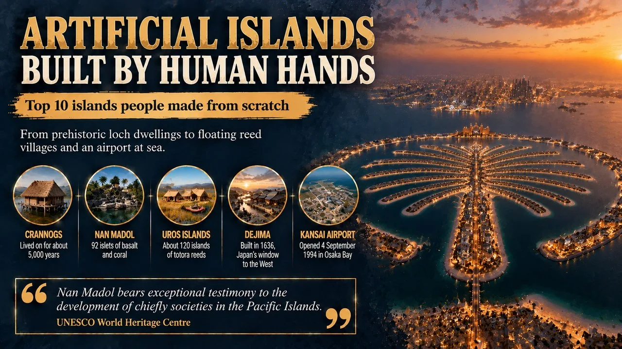
Islands built by human hands range from prehistoric Scottish loch dwellings to floating reed villages, a drained Dutch polder and an airport in Osaka Bay.
This Finepedia guide, written in October 2026, looks at 10 remarkable islands that people made rather than nature. The facts come from heritage bodies, airport and government sources, archaeological studies and encyclopaedias, and where a figure is uncertain we say so. These islands show how people have used wood, stone, reeds, sand and pumps to create new ground in water, for safety, trade, defence, farming or simply more space. If you enjoy unusual places, you may also like Finepedia's guides to phantom islands that fooled mapmakers and the best-preserved medieval towns in Europe.
How We Chose These
We picked ten islands that are wholly or mostly made by people, chosen to cover a wide spread of history, from prehistoric times to the 21st century, and every inhabited continent we could. Some are ancient ruins, some are busy cities and one is a tiny platform claimed as a country. The list runs roughly in date order, from the oldest to the newest. For each one you will find a short profile, four key facts and one more note on why it matters or a surprising detail.
The 10 Artificial Islands at a Glance
| No. | Island | Location | Built | Made from |
|---|---|---|---|---|
| 1 | Crannogs | Scotland and Ireland | from about 3600 BC | timber, stone and brush |
| 2 | Nan Madol | Pohnpei, Micronesia | about AD 1180 onward | basalt and coral |
| 3 | Uros floating islands | Lake Titicaca, Peru | centuries old, still rebuilt | totora reeds |
| 4 | Dejima | Nagasaki, Japan | 1636 | earth fill and stone walls |
| 5 | Fort Boyard | off western France | 1801 to 1857 | stone on a sandbank |
| 6 | Flevopolder | Netherlands | 1955 to 1968 | drained lake bed |
| 7 | Sealand (Roughs Tower) | North Sea, off England | 1943 | steel and concrete sea fort |
| 8 | Kansai Airport island | Osaka Bay, Japan | opened 1994 | rock and earth fill |
| 9 | Hulhumalé | Maldives | from 1997 | sand pumped from the seabed |
| 10 | Palm Jumeirah | Dubai, UAE | 2001 to 2006 | sand and rock |
1. Crannogs Were Home to People for 5,000 Years
A crannog is a small island built in a lake, loch, bog or estuary, found mainly in Scotland and Ireland. Builders piled up brush, stone and timber on the bottom, sometimes held in place with wooden posts, and then put houses on top. People lived on crannogs for about five millennia, from the Neolithic period until as late as the 17th or early 18th century.
Key Facts
- Found in: Scotland and Ireland
- Oldest known: Loch Bhorgastail and Eilean Dòmhnuill, from about 3600 BC
- Materials: timber, stone and brush
- Name: from the Irish word crann, meaning tree
Did You Know?
In the Outer Hebrides, where there were few trees, crannogs were built entirely of stone. A reconstructed crannog at the Scottish Crannog Centre on Loch Tay lets visitors see how these homes may have looked. It was badly damaged by fire in June 2021, and work to rebuild it followed.
2. Nan Madol Is a Ruined City of 92 Islets
Nan Madol lies just off the eastern shore of Pohnpei, a high volcanic island and one of the four states of the Federated States of Micronesia. It is made up of 92 small artificial islets of stone and coral fill, separated by tidal canals, within a core zone roughly 1.5 kilometres long and half a kilometre wide. From here the Saudeleur dynasty ruled Pohnpei until about 1628.
Key Facts
- Location: Pohnpei, Federated States of Micronesia
- Islets: 92
- Megalithic building: from about AD 1180
- Nicknames: Venice of the Pacific
Why It Matters
The walls are made of huge columns of basalt, laid like logs in a crisscross pattern, and no one knows exactly how they were moved. Local legend says two sorcerer brothers flew the stones into place with the help of a dragon. UNESCO counts more than 100 islets in the wider site, holding the remains of stone palaces, temples, burial places and homes. UNESCO listed Nan Madol as a World Heritage Site in 2016 and at the same time put it on its list of sites in danger, because of overgrown vegetation, storm surges and collapsing stonework.
3. The Uros Live on Floating Islands Made of Reeds
On Lake Titicaca, near the Peruvian city of Puno, the Uru people live on a group of about 120 floating islands that they build themselves. The islands are made from the totora reed that grows in the lake. A thick base of tangled reed roots, one to two metres deep, keeps each island afloat, and fresh layers of dried reeds are added on top.
Key Facts
- Location: Lake Titicaca, near Puno, Peru
- Number: about 120 islands
- Material: totora reeds and their roots
- Lifespan of an island: about 25 years
Did You Know?
The islands were first built for defence, because a whole island could be shifted away from danger, and many still have a lookout tower. The Uru also use totora to make boats and houses. The reeds rot from below, so new layers must be added regularly, and after about 25 years a family builds a fresh island and lets the old one sink. Tourism is now an important source of income, and visitors arrive by motorboat to see the islands and buy crafts.
4. Dejima Was Japan's Only Window to the West
Dejima was a small fan-shaped island built in 1636 in the harbour of Nagasaki, Japan. It was created to hold Portuguese traders apart from Japanese society, and after the Portuguese were thrown out in 1639, Dutch East India Company traders were moved there in 1641. For more than 200 years no other spot in Japan let Western merchants live and trade.
Key Facts
- Location: Nagasaki, Japan
- Built: 1636
- Dutch trading post: 1641 to 1858
- National historic site: since 1922
Why It Matters
Through Dejima, Japanese scholars learned about Western medicine, science and technology in a movement called rangaku, or Dutch learning. Land reclamation later swallowed the island into the city, but Nagasaki has been rebuilding its old houses, and there are long-term plans to surround it with water again.
5. Fort Boyard Rises Straight From the Sea
Fort Boyard is a stone fort built on a sandbank in the strait that separates two French islands, Aix and Oléron, off the west coast of France. A fort here was first suggested in the 17th century, but work only began under Napoleon in 1801 and was not finished until 1857. The oval fort is 68 metres long, 31 metres wide and has walls 20 metres high.
Key Facts
- Location: Pertuis d'Antioche, off western France
- Built: 1801 to 1857
- Size: 68 m by 31 m
- Garrison: room for about 250 men
Did You Know?
By the time the fort was ready, cannons could fire much farther, so it was hardly needed. For a short time after 1871 it held prisoners, and in 1913 it was abandoned and left to crumble. Since 1990 it has been the home of the famous TV game show named after it, watched in many countries. Its contestants race through the old rooms and casemates, solving puzzles and facing challenges, while viewers see the fort from every angle.
6. The Flevopolder Is Often Called the Largest Artificial Island
The Flevopolder is a huge area of farmland and towns in the Netherlands that was once the bottom of the Zuiderzee, an inlet of the North Sea. Dutch engineers built dikes around it and pumped the water out, draining the north-east half by 1957 and the south-west half by 1968. Unlike earlier polders, it was left surrounded by lakes and channels, so many experts rank it first among artificial islands by size.
Key Facts
- Location: Flevoland province, Netherlands
- Drained: 1955 to 1968
- Area: roughly 970 square km
- Largest city: Almere
Why It Matters
The Flevopolder was the last big piece of the Zuiderzee Works, one of the largest water-control projects ever carried out. Leaving it surrounded by water helped stop the nearby mainland from sinking. Lelystad is named after Cornelis Lely, the engineer who first planned the Zuiderzee Works. Today the polder is home to the cities of Almere and Lelystad, both founded on land that was under water within living memory.
7. Sealand Claims to Be a Country on a Sea Fort
The Principality of Sealand is a tiny micronation, recognised by no government, on HM Fort Roughs, a wartime sea fort in the North Sea about 11 kilometres off the coast of Suffolk, England. The fort was built in 1943 to protect shipping lanes, then towed out and sunk onto a sandbank. In 1967 Paddy Roy Bates took it over from pirate radio broadcasters and later declared it an independent state.
Key Facts
- Location: Rough Sands, North Sea
- Built: 1943, one of the Maunsell sea forts
- Claimed as a state: from 1967
- Population: one permanent resident as of 2024
Did You Know?
In 1975 Sealand created its own constitution, flag, anthem, currency and passports. In 1978 armed mercenaries seized the fort and held Michael Bates, the founder's son, hostage, but he soon won it back. No country recognises Sealand, and since 1987, when Britain pushed its territorial limit out to 12 nautical miles, the fort has sat inside British waters. Even so, the Bates family still promotes Sealand, and it has become one of the best-known micronations in the world.
8. Kansai Airport Was Built on an Island in Osaka Bay
Kansai International Airport opened on 4 September 1994 on an artificial island in Osaka Bay, Japan, built to ease crowding at Osaka's older airport. Three mountains were dug away to supply fill for the first island, which was built on deep soft clay. A second island was added later, and the two together cover about 1,055 hectares.
Key Facts
- Opened: 4 September 1994
- Location: Osaka Bay, about 38 km from central Osaka
- Area: about 1,055 hectares across two islands
- Terminal 1: about 1.7 km long, designed by Renzo Piano
Why It Matters
The soft seabed made the island sink faster than expected, and much of the extra cost came from dealing with it. Engineers fitted the terminal with adjustable columns so it could be kept level. In September 2018 Typhoon Jebi flooded parts of the airport and closed it for days, a reminder of the risks of building on the sea.
9. Hulhumalé Was Raised to Face Rising Seas
Hulhumalé is a new island city in the Maldives, raised by piping sand up from the seabed onto a shallow lagoon near the capital, Malé. Work began on 16 October 1997, and the first residents moved in in 2004. It now covers about 4 square kilometres, so only three islands in the Maldives are bigger.
Key Facts
- Location: North Malé Atoll, Maldives
- Reclamation began: 16 October 1997
- Officially opened: 12 May 2004
- Population: more than 50,000 by 2019
Why It Matters
The Maldives is one of the lowest-lying countries on Earth, so rising sea levels are a serious threat. The first phase alone cost tens of millions of US dollars and was carried out partly by Belgian dredging firms. Hulhumalé was built higher than most of the natural islands, giving the crowded capital region extra space and a safer place to live as the seas rise.
10. Palm Jumeirah Was Shaped Like a Palm Tree
Palm Jumeirah is a group of artificial islands off the coast of Dubai, made by piling sand and rock on the seabed of the Persian Gulf. Seen from above, it looks like a palm tree, with a trunk, a set of fronds and a curved outer crescent. Building started in June 2001, and the first homes were handed over in 2006. It became the first of a planned family of Palm Islands that, together with other projects, aim to add hundreds of kilometres of new shoreline to Dubai.
Key Facts
- Location: Jumeirah, Dubai
- Construction began: June 2001
- Built by: the Dutch dredging firm Van Oord
- Population: over 25,000 by 2022
Did You Know?
The trunk holds shops and flats, the fronds are lined with villas, and the outer crescent is reserved for luxury hotels. A monorail of about 5.4 km runs along the trunk. In 2009 reports suggested the island was sinking by about 5 mm a year, though the developer said there were no signs of structural problems.
Frequently Asked Questions
What is the largest artificial island in the world?
By many definitions it is the Flevopolder in the Netherlands, at about 970 square kilometres. It was made by draining part of a former sea inlet rather than by piling up material, so some lists prefer to name islands built from fill instead.
Do artificial islands sink?
Many do settle over time, especially when built on soft clay or sand. Kansai Airport is the best-known case, and engineers there must keep adjusting the buildings to keep them level. Island builders now often load the ground in advance, add drains and leave the fill to settle for years before anything heavy goes on top.
Conclusion
From prehistoric crannogs to a palm-shaped resort, people have been building islands for thousands of years, for safety, trade, defence and space to live. These ten show how much skill it takes to make new ground in water, and how hard it can be to keep it there. For more remarkable places, read Finepedia's guides to phantom islands that fooled mapmakers and the best-preserved medieval towns in Europe.
- UNESCO World Heritage Centre, Nan Madol: Ceremonial Centre of Eastern Micronesia, whc.unesco.org/en/list/1503.
- Kansai Airports, Kansai International Airport information.
- Housing Development Corporation of the Maldives, Hulhumalé information.
- Scottish Crannog Centre, Loch Tay, information on crannogs.
- Nagasaki City, Dejima restoration project.
- Wikipedia (accessed October 2026), articles on the crannog, Nan Madol, the Uru people, Dejima, Fort Boyard, Flevopolder, the Principality of Sealand, Kansai International Airport, Hulhumalé and Palm Jumeirah.
- 10 Most Today, 10 Most Awesome Artificial Islands, 10mosttoday.com (topic reference).












Log in with