



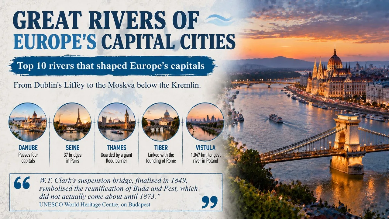
Great rivers of Europe's capital cities include the Danube, which links four national capitals, and the Seine, where Parisians can swim again in summer.
This Finepedia guide, written in October 2026, follows 10 rivers that shaped the capitals of Europe, from Dublin in the west to Moscow in the east. The facts come from encyclopaedias, city and national heritage bodies and news reports. River lengths vary between sources because rivers are measured in different ways, so we give the commonly quoted figure and note where estimates differ. If you enjoy geography, you may also like the Finepedia guides Longest Rivers in the World: Top 10 by Length and Best-Preserved Medieval Towns in Europe: Top 10.
How We Chose These
Almost every European capital grew up beside water, so we chose ten rivers that pass through a national capital and that each tell a different story about their city. We looked for a mix of large and small rivers, from famous waterways such as the Danube to shorter rivers such as Dublin's Liffey. The list runs roughly from west to east across the continent. Each entry has a short profile, four key facts and one more note on why the river matters or a surprising detail.
The 10 Rivers at a Glance
| No. | River | Capital | Length (approx.) | Standout fact |
|---|---|---|---|---|
| 1 | Liffey | Dublin | 132 km | splits the city into Northside and Southside |
| 2 | Thames | London | 346 km | guarded by a giant flood barrier |
| 3 | Seine | Paris | 777 km | banks listed by UNESCO |
| 4 | Spree | Berlin | about 400 km | home to Museum Island |
| 5 | Vltava | Prague | about 430 km | inspired Smetana's music |
| 6 | Tiber | Rome | 406 km | linked with the city's founding legend |
| 7 | Danube | Vienna, Bratislava, Budapest, Belgrade | 2,850 km | touches 10 countries |
| 8 | Vistula | Warsaw | 1,047 km | longest river in Poland |
| 9 | Dnieper | Kyiv | about 2,200 km | old trade route to Byzantium |
| 10 | Moskva | Moscow | about 500 km | gave the city its name |
1. The Liffey Divides Dublin in Two
The River Liffey rises in a bog in the Wicklow Mountains south of Dublin and winds through three counties before reaching the Irish Sea in Dublin Bay. In the city it is more than a river: it is the line between the Northside and the Southside, two halves of Dublin that locals often describe as having their own character.
Key Facts
- Length: about 132 km
- Source: Liffey Head Bog in the Wicklow Mountains
- Counties: Wicklow, Kildare and Dublin
- Famous crossing: the Ha'penny Bridge, a cast-iron footbridge
Did You Know?
The writer James Joyce turned the Liffey into a character in his novel Finnegans Wake, where it appears as Anna Livia Plurabelle. Many people believe the Guinness brewery takes its water from the Liffey, but it actually pipes water in from the Wicklow Mountains. Even so, around 60% of the river's flow is drawn off for drinking water and industry.
2. The Thames Is London's Tidal Highway
The Thames rises in the Cotswolds of Gloucestershire and runs east past Oxford and Windsor before passing through the heart of London and out to the North Sea. It is the longest river that lies wholly within England. In London it is tidal, rising and falling by about 7 m twice a day as far upstream as Teddington Lock.
Key Facts
- Length: about 346 km
- Source: Thames Head, Gloucestershire
- Rank: second-longest river in the UK, after the Severn
- Wildlife: up to about 700 grey and harbour seals live in the estuary
Why It Matters
In the hot summer of 1858, sewage in the Thames caused the Great Stink, a smell so bad that Parliament had trouble sitting. It led to London's huge new sewers. Today, the Thames Barrier, a row of steel gates 520 m across the river at Woolwich, shields central London from North Sea storm surges. It has been in use from 1982 and was formally opened by Queen Elizabeth II in 1984.
3. The Seine Has Banks Protected by UNESCO
The Seine flows north-west across northern France from a source near Dijon, through Paris to meet the sea in the English Channel near Le Havre. In Paris, the stone quays on both banks, lined with grand buildings and bookstalls, have been on the UNESCO World Heritage List since 1991.
Key Facts
- Length: about 777 km
- Bridges: 37 in Paris, including the Pont Neuf and Pont Alexandre III
- Source: a Paris city property since 1864
- Swimming: banned in 1923 because of pollution
Why It Matters
For a century, swimming in the Seine was forbidden because the water was too dirty. A big clean-up plan, worth about €1.4 billion, was launched in 2018 ahead of the 2024 Paris Olympics, when swimming races were held in the river despite some delays over water quality. In July 2025, Paris opened public swimming spots in the Seine for the first time in about 100 years.
4. The Spree Flows Past Berlin's Museum Island
The Spree begins in the hills of Lusatia in eastern Germany, close to the Czech border, and flows north through Brandenburg into Berlin. On its way it spreads out into the Spreewald, a maze of small channels and forests that forms an inland delta and a protected biosphere reserve. In Berlin it passes some of the city's best-known sights, including the Reichstag and Berlin Cathedral, before joining the Havel.
Key Facts
- Length: about 400 km
- Source: the Lusatian Highlands in Saxony
- Ends: in the Havel, at Spandau in west Berlin
- Berlin sights: the Reichstag, Berlin Cathedral and Museum Island
Did You Know?
In central Berlin, one island in the river holds five major museums, including the Pergamon Museum and the Altes Museum. Known as Museum Island, it was built between 1830 and 1930 and joined the UNESCO World Heritage List in 1999. Since 2004, Berliners have also been able to cool off in a swimming pool floating on the river.
5. The Vltava Is the Czech National River
No river in the Czech Republic is longer than the Vltava. It rises in the Bohemian Forest and flows past the historic towns of Český Krumlov and České Budějovice on its way to Prague, then joins the Elbe. Czechs often call it their national river, and its German name is the Moldau.
Key Facts
- Length: about 430 km
- Cities: Prague, plus Český Krumlov and České Budějovice upstream
- Joins: the Elbe at Mělník
- Name: possibly from old Germanic words for wild water
Why It Matters
The composer Bedřich Smetana wrote a piece of music called Vltava, also known as The Moldau, that follows the river from its springs to Prague. It forms part of his set of works called Má vlast (My Country) and is one of the best-loved pieces of Czech music. The river can be dangerous, too: in the 2002 floods, the Vltava badly weakened Prague's oldest bridge, the Charles Bridge.
6. The Tiber Is Linked With the Founding of Rome
Only two Italian rivers are longer than the Tiber. It rises in the Apennine Mountains and runs south through Tuscany, Umbria and Lazio to reach the Tyrrhenian Sea near Ostia. Rome grew up on its eastern bank, and legend says the twins Romulus and Remus were washed ashore here before founding the city in 753 BC.
Key Facts
- Length: about 406 km
- Source: Mount Fumaiolo in the Apennines
- Island: Tiber Island, where the river could be forded in ancient times
- Embankments: high stone walls built from 1876
Did You Know?
The Tiber once flooded Rome often, including a disaster in 1557 that killed more than 1,000 people. Today high walls hold it in, with tree-lined roads called lungoteveri running along the top. The river is so closely tied to Rome that "crossing the Tiber" has become a phrase for converting to the Roman Catholic faith.
7. The Danube Passes Through Four Capitals
Only the Volga is longer than the Danube among Europe's rivers. It begins in Germany's Black Forest and flows south-east to the Black Sea, crossing or forming the border of ten countries, a world record for a river. Four national capitals sit beside it, namely Vienna, Bratislava, Budapest and Belgrade.
Key Facts
- Length: about 2,850 km
- Capital cities: Belgrade, Budapest, Bratislava and Vienna
- Mouth: the Danube Delta, mostly in Romania
- History: formed part of the northern border of the Roman Empire
Why It Matters
Budapest itself was formed in 1873 when the towns of Buda and Óbuda on the west bank were joined with Pest on the east bank. At the river's end, the Danube Delta is one of Europe's best-preserved wetlands, on the UNESCO World Heritage List from 1991 and home to more than 300 types of bird. The river also inspired Johann Strauss's famous waltz The Blue Danube.
8. The Vistula Is Poland's Greatest River
Poland has no longer river than the Vistula, and no river emptying into the Baltic Sea is longer either. It rises in the Silesian Beskids on the mountain of Barania Góra and runs north through Kraków, Warsaw, Toruń and Gdańsk. Poles see it as a symbol of their country, and the phrase "the land on the Vistula" can simply mean Poland.
Key Facts
- Length: about 1,047 km
- Source: Barania Góra in southern Poland
- Mouth: the Gulf of Gdańsk on the Baltic Sea
- Cities: Kraków, Warsaw, Toruń and Gdańsk
Did You Know?
The Vistula has been written about for nearly 2,000 years. The Roman writer Pomponius Mela mentioned it around AD 40. Geologists also named the last ice age in northern Europe, the Weichselian glaciation, after its German name, Weichsel.
9. The Dnieper Carried Traders Past Kyiv
The Dnieper is one of Europe's great rivers. Its source lies in Russia's Valdai Hills, not far from Smolensk, and it then crosses Belarus and Ukraine before entering the Black Sea. It is the longest river in both Ukraine and Belarus, and Ukraine's capital, Kyiv, stands on its banks.
Key Facts
- Length: about 2,145 to 2,200 km, depending on the source
- Rank: fourth-longest river in Europe
- Countries: Russia, Belarus and Ukraine
- Ukrainian name: Dnipro
Why It Matters
More than 1,000 years ago, the Dnieper formed a key stretch of the so-called Varangians-to-Greeks trade road, which linked Scandinavia with the Byzantine Empire. Viking traders and others sailed down the river past Kyiv, which grew into the centre of the medieval state of Kievan Rus'. In the 20th century, engineers dammed the river in several places to generate hydroelectric power.
10. The Moskva Gave Moscow Its Name
The Moskva rises west of Moscow and flows east through the Russian capital, winding below the walls of the Kremlin. It then joins the Oka, which in turn feeds the Volga. The city is named after the river, and in Russian both are called Moskva.
Key Facts
- Length: about 473 to 503 km, depending on the source
- Width in Moscow: about 120 to 200 m, narrowest beside the Kremlin
- Joins: the Oka at Kolomna
- First stone bridge: built in 1692
Did You Know?
The Moskva used to become too shallow for boats in dry summers. The Moscow Canal, built between 1932 and 1937, brought in water from the Volga, making shipping reliable. Moscow also takes much of its drinking water from the river.
Frequently Asked Questions
Which river flows through the most European capitals?
The Danube, which passes four capitals, from Vienna and Bratislava to Budapest and Belgrade. It also touches ten countries on its way to the Black Sea.
Can you swim in the Seine in Paris?
Yes, at certain spots and times. After a ban lasting about a century, Paris opened public swimming areas in the Seine in July 2025, although water quality can still close them after heavy rain.
Conclusion
From the Liffey in Dublin to the Moskva in Moscow, these ten rivers show how water has shaped the capitals of Europe, carrying trade, inspiring music and dividing cities into distinct halves. Many are now cleaner and more loved than ever. For more on geography, read the Finepedia guides Longest Rivers in the World: Top 10 by Length and Best-Preserved Medieval Towns in Europe: Top 10.
- UNESCO World Heritage Centre, Paris, Banks of the Seine, whc.unesco.org.
- UNESCO World Heritage Centre, Museumsinsel (Museum Island), Berlin, whc.unesco.org.
- UNESCO World Heritage Centre, Danube Delta, whc.unesco.org.
- UK Environment Agency, The Thames Barrier, gov.uk.
- Wikipedia (accessed October 2026), articles on River Liffey, River Thames, Thames Barrier, Seine, Spree (river), Museum Island, Vltava, Tiber, Danube, Vistula, Dnieper and Moskva (river).
- 10 Most Today, 10 Rivers That Flow Through Europe's Capital Cities, 10mosttoday.com (topic reference).








Log in with