



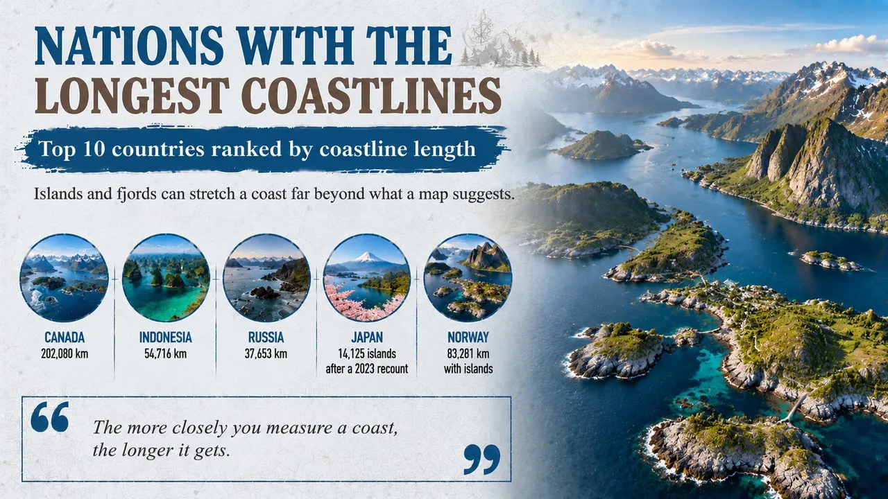
Nations with the longest coastlines are led by Canada, whose 202,080 km of shore would circle the equator about five times, with Indonesia next in line.
This Finepedia guide, written in October 2026, ranks the ten nations whose coasts measure longest, from vast Canada to island nations scattered across the Pacific. The figures come from the CIA World Factbook, which is the most widely quoted single source, checked against national mapping agencies and encyclopaedias. Coastline lengths depend heavily on how they are measured, so we explain the method and note where other sources give very different numbers. If you enjoy geography, you may also like the Finepedia guides Largest Countries in the World: Top 10 by Area and Top 10 Largest Islands in the World.
How We Chose These
We ranked independent countries by the coastline lengths given in the CIA World Factbook. We left out Greenland, which the Factbook credits with 44,087 km of coast, because it is a self-governing part of the Kingdom of Denmark rather than a separate country. The Factbook does not say what scale it used for each country, so its figures are best seen as a rough guide. Each entry has a short profile, four key facts and one more note on why it matters or a surprising detail.
The 10 Countries at a Glance
| No. | Country | Coastline (CIA World Factbook) | Main reason | Standout fact |
|---|---|---|---|---|
| 1 | Canada | 202,080 km | Arctic islands | coasts on three oceans |
| 2 | Indonesia | 54,716 km | about 17,500 islands | world's largest archipelago |
| 3 | Russia | 37,653 km | long Arctic shore | borders 13 or more seas |
| 4 | Philippines | 36,289 km | 7,641 islands | two big islands hold most of the land |
| 5 | Japan | 29,751 km | 14,125 islands | island count doubled in 2023 |
| 6 | Australia | 25,760 km | an island continent | no land borders at all |
| 7 | Norway | 25,148 km | deep fjords | 83,281 km with islands |
| 8 | United States | 19,924 km | Alaska and three oceans | 151,475 km by a detailed count |
| 9 | New Zealand | 15,134 km | about 600 islands | sea area 15 times its land |
| 10 | China | 14,500 km | long Pacific shore | about 5,000 islands |
1. Canada's Coast Beats Every Other Country's
Canada's coastline is longer than that of any other country by a wide margin, at 202,080 km in the CIA World Factbook. It touches three oceans: the Pacific in the west, the Atlantic in the east and the Arctic in the north. That is nearly four times the length of Indonesia's coast, the next on the list.
Key Facts
- Coastline: 202,080 km
- Oceans: Pacific, Atlantic and Arctic
- Arctic islands: 36,563, covering about 1.4 million square km
- Comparison: roughly five times the distance around the equator
Why It Matters
Most of Canada's coast lies around the Canadian Arctic Archipelago, a maze of 36,563 islands in the far north, mostly within Nunavut and the Northwest Territories. Every island adds its own shoreline, which is why Canada's total is so huge. Much of this coast is frozen for long parts of the year, and climate change is starting to open some Arctic waterways to ships.
2. Indonesia Is the World's Largest Archipelago
Indonesia straddles the equator, lying where the Indian Ocean meets the Pacific, made up of thousands of islands, including Sumatra, Java, Sulawesi and parts of Borneo and New Guinea. With 54,716 km of coastline, it ranks second in the world. It is also the largest archipelago, or chain of islands, on Earth.
Key Facts
- Coastline: 54,716 km
- Islands: about 17,500, depending on the survey
- Oceans: Indian and Pacific
- Rank: largest archipelago on Earth
Did You Know?
Nobody agrees exactly how many islands Indonesia has. A national survey carried out between 2007 and 2010 counted about 17,500, while an earlier survey in 2002 found 18,307. The figure in the CIA World Factbook is 17,508. The difference comes from how small rocks, sandbanks and islands that appear only at low tide are counted.
3. Russia Faces Three Oceans
Russia, the biggest country by area, has 37,653 km of coastline. Most of it runs along the frozen Arctic Ocean in the north, but Russia also has coasts on the Pacific in the east and on seas linked to the Atlantic, such as the Baltic and the Black Sea. Its long shore on the Caspian Sea does not count, because the Caspian is landlocked.
Key Facts
- Coastline: 37,653 km
- Oceans: Arctic, Pacific and Atlantic, through its seas
- Seas: links with more than 13 marginal seas
- Note: the Caspian Sea shore is not counted as coastline
Why It Matters
Russia, Canada and the United States are the only three countries with coasts on three oceans. Much of Russia's Arctic coast is icebound for much of the year, but the Northern Sea Route along it is becoming more important for shipping as summer sea ice shrinks.
4. The Philippines Is Made of 7,641 Islands
The Philippines lies in the western Pacific between Taiwan and Borneo, about 800 km from the Asian mainland. It is made up of 7,641 islands, which give it 36,289 km of coastline, more than many far larger countries. Its total land area is only about 300,000 square km.
Key Facts
- Coastline: 36,289 km
- Islands: 7,641
- Largest islands: Luzon and Mindanao
- Land: the 11 largest islands hold about 95% of the land
Did You Know?
Luzon, the largest island, covers about 105,000 square km and is home to the capital, Manila. Mindanao, the second largest, covers about 95,000 square km. Together the two account for around two thirds of the country's land, while thousands of tiny islands make up the rest.
5. Japan Found Twice as Many Islands in 2023
Japan is a long chain of volcanic islands running for over 3,000 km off the eastern edge of Asia. Its five main islands, Honshu, Hokkaido, Kyushu, Shikoku and Okinawa, are surrounded by thousands of smaller ones. Its coastline measures 29,751 km.
Key Facts
- Coastline: 29,751 km
- Islands: 14,125, after a 2023 recount
- Main islands: Honshu, Hokkaido, Kyushu, Shikoku and Okinawa
- Distance to the sea: no point is more than about 150 km away
Why It Matters
For decades Japan officially had 6,852 islands. In 2023, the government recounted them using digital maps and found 14,125, more than twice as many. The coastline itself did not change, but the new count shows how much better mapping can change what we know. It is a perfect example of the coastline paradox described in our FAQ.
6. Australia Is an Island Continent
Only five countries are bigger than Australia, and it is the only one that covers an entire continent. With 25,760 km of coastline, it ranks sixth on this list, and most of its people live close to the sea. Its shores range from tropical mangroves in the north to the Great Barrier Reef and the cold waters of Tasmania.
Key Facts
- Coastline: 25,760 km
- Size: about 7.7 million square km, sixth in the world
- Borders: no land borders with any other country
- Islands: thousands, including Tasmania
Did You Know?
Although Australia has no land borders, it shares sea boundaries with several neighbours, including Indonesia, Papua New Guinea, Timor-Leste, the Solomon Islands, New Zealand and France's territory of New Caledonia.
7. Norway's Fjords Make Its Coast Incredibly Long
Norway's coast is famous for its fjords, long and narrow sea inlets carved by glaciers during the ice ages. The CIA World Factbook gives a figure of 25,148 km for the mainland coast. But measurements that include its many islands give 83,281 km, which would place it second only to Canada.
Key Facts
- Coastline: 25,148 km on the mainland
- With islands: 83,281 km
- Islands and islets: about 320,000
- Longest fjord: the Sognefjord, about 205 km
Why It Matters
During the ice ages, glaciers gouged deep valleys that the sea later flooded. The Sognefjord, known as the King of the Fjords, runs 205 km inland and reaches a depth of 1,308 m. Kartverket, the Norwegian mapping authority, counts 239,057 islands plus another 81,192 islets off the coast.
8. The United States Has Shores on Three Oceans
The CIA World Factbook credits the United States with 19,924 km of coastline, along the Atlantic, the Pacific, the Gulf of Mexico and, in Alaska, the Arctic Ocean. It is one of just three countries with coasts on three oceans. Hawaii and the American territories add many more kilometres of island shores.
Key Facts
- Coastline: 19,924 km (Factbook)
- Detailed shoreline: 151,475 km, measured by NOAA
- Oceans: Atlantic, Pacific and Arctic
- Biggest share: Alaska
Did You Know?
The US National Oceanic and Atmospheric Administration has measured the shoreline of the 50 states in great detail, including bays, islands and rivers up to the point where the tide stops. Its total is about 151,475 km, more than seven times the Factbook figure. Both numbers are correct; they simply measure in different ways.
9. New Zealand Has a Huge Sea Area
New Zealand is made up of two main islands, the North Island and the South Island, plus around 600 smaller islands. Together they give it 15,134 km of coastline. Fiordland, in the South Island's far south-west corner, is a wild area of deep sounds carved by ice.
Key Facts
- Coastline: 15,134 km
- Islands: about 600
- Main islands: North Island and South Island
- Exclusive economic zone: about 4.08 million square km
Why It Matters
Because of its long coastline and remote islands, New Zealand controls one of the largest exclusive economic zones in the world, more than 15 times the size of its land area. This sea area gives it rights over fishing, minerals and energy far out into the Pacific.
10. China's Coast Faces Three Seas
China's coastline runs along three arms of the Pacific: the South China Sea, the Yellow Sea and the East China Sea. The CIA World Factbook gives it 14,500 km. Chinese sources often quote about 18,000 km for the mainland coast alone, showing again how different methods give different answers.
Key Facts
- Coastline: 14,500 km (Factbook)
- Other estimate: about 18,000 km for the mainland
- Seas: South China, East China and Yellow seas
- Islands: about 5,000
Did You Know?
More than half of China's coastline, mostly in the south, is rocky, while most of the rest is sandy. The coastal provinces, with busy ports such as Shanghai and Shenzhen, have become the centre of the country's export trade and its strongest economic region.
Frequently Asked Questions
Why do coastline lengths differ between sources?
Because of the coastline paradox: the more closely you measure a coast, following every bay and rock, the longer it gets. The scientist Lewis Fry Richardson first studied this, and the mathematician Benoit Mandelbrot explored it in a famous 1967 paper that asked how long Britain's coastline really is.
Which country has the second-longest coastline?
By CIA World Factbook figures, Indonesia is second with 54,716 km. However, if Norway's islands are counted, as some measurements do, Norway would be second with 83,281 km.
Conclusion
From Canada's Arctic islands to Norway's fjords and the island chains of Asia, these ten countries show how islands and inlets can stretch a coastline far beyond what a map first suggests. Their long shores shape their trade, wildlife and ways of life. For more on world geography, read the Finepedia guides Largest Countries in the World: Top 10 by Area and Top 10 Largest Islands in the World.
- Central Intelligence Agency, The World Factbook, Coastline field (2025 edition).
- Kartverket (Norwegian Mapping Authority), island and islet counts for Norway.
- Geospatial Information Authority of Japan, 2023 island recount.
- National Oceanic and Atmospheric Administration, Shoreline Mileage of the United States.
- Mandelbrot, B., paper on the length of Britain's coast and statistical self-similarity, Science, volume 156, 1967.
- Wikipedia (accessed October 2026), articles on List of countries by length of coastline, Coastline paradox, Canadian Arctic Archipelago, Sognefjord and the geography of Indonesia, the Philippines, Japan, Norway, Australia, New Zealand, Russia, China and the United States.
- 10 Most Today, 10 Countries With the Longest Coastline, 10mosttoday.com (topic reference).












Log in with